Intern Projects
Extreme Precipitation Climatology
Ryan Haas– University of Albany, Applied Atmospheric Science
Observer Guide – Charlie Peachey
My research last summer examined the climatology of extreme precipitation days on Mount Washington from 1935 through 2024. In this study, extreme precipitation days are defined as the top 1% of wet days (days that featured 0.01” or more of liquid equivalent precipitation). The top 5% of precipitation days were also analyzed to build a more robust climatology, given the much larger sample size. The project unveiled that top 1% extreme precipitation days occur most frequently in the autumn months and peak during October. In addition, there is a secondary peak in top 1% precipitation days during the month of February. The Spring and early summer months featured fewer top 1 % days, with the fewest being recorded in April. The top 5% precipitation day climatology featured a slightly different pattern, with a lull in winter and early spring and a broad peak from July through December. This project also examined storm types, storm tracks, and the prevailing wind direction associated with the top 1% and top 5% extreme precipitation days. Most storms that produced extreme precipitation on Mount Washington were extratropical cyclones that tracked to the west of the summit. In addition, the majority of the top 1% days featured a prevailing wind direction from the southeast. The majority of the top 5% days featured southeasterly winds in winter and spring, and westerly winds in summer and autumn.
Example figure:
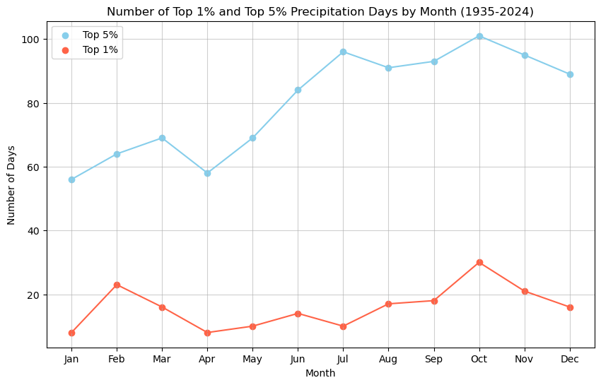
The number of top 1% and top 5% precipitation days recorded each month on the summit of Mount Washington from 1935-2024. Top 1% days include days that recorded at least 2.69” of precipitation, while top 5% days saw at least 1.46”.
Presentation: MWOBS Extreme Precipitation Climatology Research Project
Anthocyanins and the PhenoCam Network
Alyssa Bélanger– Colorado State University, Natural Sciences
Observer Guide – Karl Philippoff
This fall, my research focused on analyzing data from the PhenoCam Network after I got motivation from anthocyanins, one of the red pigments in leaves. They may have photoprotective properties for the leaves, allowing more nutrients to be saved in the branches before the leaves fall off.
I analyzed green chromatic coordinate (GCC) and red chromatic coordinate data (RCC) from the PhenoCam Network. They measure these values based on the images their phenocams take at different sites across the globe. GCC and RCC are a measure of how green or how red an image is, giving an indicator for when peak fall coloration occurs. By using different thresholds for GCC and RCC, I obtained when peak would be defined based on each method. For example, I used a 90% threshold for RCC. By this definition, peak would occur when RCC values reach 90% of their range for the year. The 20% threshold for GCC means that “peak” would be defined when GCC drops to 20% of its yearly range. Visual assessment was done on the images from PhenoCam, determining subjective peak dates to which dates from GCC and RCC were compared. Below is a plot showing how far off GCC and RCC dates differ from the visual dates, represented by the y=0 line. GCC had a standard deviation of 7.59 while RCC was 2.63. RCC turned out to be more accurate indicator for when peak color occurs. I hope for the future that by analyzing RCC data more, we can create more accurate fall foliage forecasts.
Example figure:
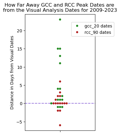
Spread of how far off peak foliage dates determined using GCC (green dots) and RCC (red dots) were from the dates obtained from visual analysis.
Investigating North Atlantic Oscillation Impact on Extreme Snowfall Events
Amber Stokes– University of Delaware, Meteorology
Observer Guide – Charlie Peachey
The North Atlantic Oscillation (NAO) is an interannual, global teleconnection split into two phases: positive and negative. The positive phase correlates with stronger high and low pressure centers in the Atlantic; the negative phase correlates with weaker centers. This global teleconnection has more prominent impacts on the Northeastern United States during the winter months, and is responsible for the changing intensity of mean sea level pressure centers over the Northern Atlantic Ocean.
This research investigates if there is a statistically significant difference in average snowfall between the most positive and most negative NAO days and analyzes whether the NAO influences the distribution of extreme snowfall on Mount Washington. Statistical methods such as a non-parametric Monte Carlo analysis and a parametric generalized extreme value (GEV) distribution are used to help identify these relationships. The results of my study found that while average snowfall between NAO phases does not differ significantly, extreme snowfall behavior changes meaningfully. The distribution of extreme snow events, such as intensity, variability, and likelihood, shifts with the NAO. In the future, the relationship between the NAO and other global teleconnections on extreme snowfall should be studied to uncover all the impacts on changing extreme snowfall events.
Example figure:
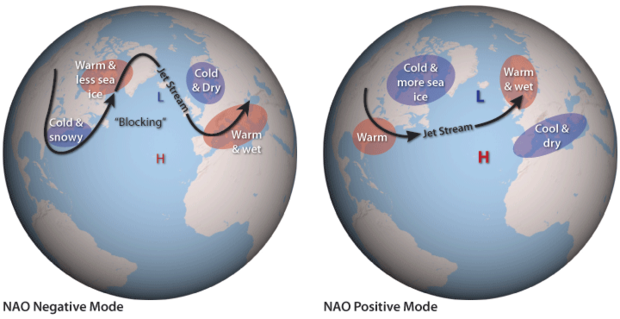
The different phases of the NAO (diagram provided by NOAA’s climate.gov NAO website).
Meteorological Factors in Autumn Phenology
Madelynn Smith– University of North Carolina, Meteorology and Earth Sciences
Observer Guide – Karl Philippoff
My research this summer investigated fall foliage and how different meteorological factors such as temperature and drought impacted the timing and intensity of autumn senescence. This project was developed to establish a base for not only operational forecasting purposes here at the Observatory, but also to lay the groundwork for future phenology research. While meteorological factors play a secondary role in the process of deciduous leaves changing color in fall, with the primary role being shortening daylight hours heading into the season, they have impact on how vibrant the colors are in a given year, as well as the onset and duration of the fall foliage season.
Seasonally average summer temperatures with ample moisture, in combination with a drier autumn with sunny days and cooler nights bring out the vibrant red colors in the maple trees. Summer and autumn temperatures, as well as soil moisture, can factor into how early or late the leaves begin to turn, and how long the color is maintained on the leaves before they fall. Understanding how meteorology affects fall foliage is important since ‘leaf-peeping’ tourism is such a strong part of New England’s economy.
Example figure:
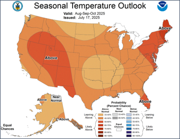
Seasonal Temperature Outlook issued July 17, 2025.
Convective Patterns and Favorability in New England
Max Sasser– University of Oklahoma, Meteorology
Observer Guide – Karl Philippoff
This project focuses on the environmental variables that may be influencing the increase of convective activity in the White Mountains as the region experiences an increase in thunderstorm activity.
As the global climate shifts, so do local weather patterns; I hope my research can support discussions on convective phenomena in the White Mountains, with future work aimed at investigating the relationship between environmental parameters and convective phenomena type and the relationship between increase in CAPE (convective available potential energy) and severity of thunderstorms.
Example figure:
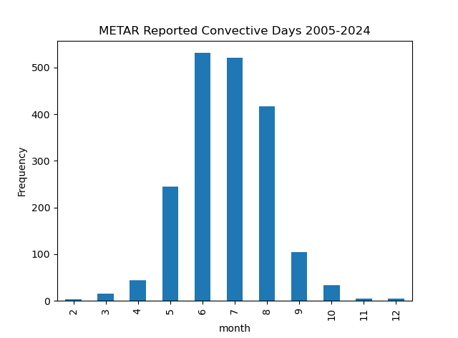
METAR Reported Convective Days, 2005-2024
Climatology of Upslope Snow on Mount Washington
Peter Edwards– University of Massachusetts, Atmospheric Science
Observer Guide – Karl Philippoff
Orographic snowfall driven by low-level flow, commonly referred to as upslope snowfall, is a frequent occurrence on the windward slopes of mountainous terrain, in northern New England. Mount Washington, the highest peak in the northeastern U.S. at 6,288 feet (1,917 meters) situated on the Presidential Mountain range in NH oriented SW to NE making it uniquely exposed to westerly and northwesterly flow regimes , enhancing orographic lift and promote localized snow production.
This study presents a 20-year short-term climatology of upslope snowfall events on Mount Washington, New Hampshire, from 2005 to 2025. 254 upslope snow events were identified consisting of 206 single day events at 48 multi-day events. Temporal trends in both the frequency and intensity of upslope events were assessed and compared against overall seasonal snowfall trends on Mount Washington. This work helps to refine the understanding of localized snowfall processes in complex terrain and the evolving climatology of high-elevation winter weather in the northeastern United States.
Example figure:
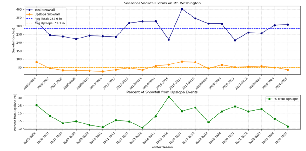
Seasonal snowfall totals on Mount Washington separated into total snowfall (blue) and snowfall from upslope events (orange) for each winter season. Dashed lines indicate the long-term seasonal average for each. The bottom panel shows the percentage of each season’s total snowfall that was attributable to upslope events, highlighting their variable but often substantial contribution to annual snowpack.
20 Year Climatology of Upslope Snow on Mount Washington (2005-2025) Presentation
Model Output Statistics (MOS) Verification on Mount Washington
Joshua Elms– Indiana University, Data Science
Jacob Garside- Plymouth State University, Meteorology
Observer Guide – Karl Philippoff
Model Output Statistics (MOS), a statistical post-processing layer on top of dynamical weather models, is integral to mountain weather forecasting. The goal of this study is to analyze the forecast skill of three MOS products (GFS MOS, NAM MOS, and NBM) in regard to five numerical variables (temperature, dewpoint, dewpoint depression, wind speed, and wind direction) at the summit of Mount Washington (station identifier: KMWN). By comparing archived MOS forecasts released at 00Z and 12Z out to 72 hours with official observations collected at the Mount Washington Observatory (MWO) between 11/01/2020 and 05/16/2024, we validate the implicit knowledge of their veteran forecasters at MWO: the GFS MOS, NAM MOS, and NBM are similarly skillful in forecasting temperature, dewpoint, and dewpoint depression, while the NBM lags significantly behind the other two models in forecasting both wind speed and direction. Analysis of the individual and aggregated cases where MOS forecasts had the highest error yields the conclusion that multiple distinct synoptic situations around KMWN are prevalent during the most errant forecasts. These results are intended to serve as guidelines for MWO’s new forecasters, replacing some of the years of experience otherwise required to understand when and how to use each MOS variant.
Example figures:

MOS verifications for temperature starting at 6 hours after the model initialization time and proceeding out to forecast hour 72 (72 hours into the future). The different colors denote the three MOS variants used in this study including the GFS (pink squares), NAM (yellow upside-down triangles), and NBM (blue circles). The top plot shows how the MAE (the mean average absolute error between the forecasted temperature and the measured temperature valid at the same time) grows into the future from about 2°F at 6 hours out to 3°F at 72 hours out. The bottom plot shows the bias between the forecasted and observed temperatures. A positive bias (above zero on this plot) would indicate that the model consistently forecasts higher temperatures than verify while a negative bias would indicate that the model consistently forecasts lower temperatures. The NBM consistently has a slight positive, while the NAM and GFS tend to be more negatively biased, though the GFS tends towards less bias a longer lead times.

Figure depicting a time during which the GFS and NAM dramatically underforecasted wind speeds on Mount Washington on Dec. 23rd, 2022. Filled contours denote wind speed, with the wind scale shown in the color bar below the figure. The yellow star shows the location of Mount Washington with a strong south to southeasterly low-level jet over the summit. Observed winds at the summit were sustained at 94kts (108mph) at this time. This map was derived from ERA5 reanalysis data.
A Study of Significant Late Season Snow and Precipitation Events in the White Mountains
George Mousmoules– Plymouth State University, Meteorology
Observer Guide– Charlie Peachey
There have been multiple studies conducted based on both observational data and climate modeling that indicated significant snow events will likely continue at a steady or increasing rate in the Northeastern U.S. This was despite a shortening winter season in the region due to climate change. This study investigated how significant late-season snow and precipitation events have been changing in frequency, intensity, and duration in the White Mountain region. This investigation analyzed data from 1995 to 2024, focusing on the period of March 1st to June 30th for each year. Data originated from the B16 daily archives kept at the Mount Washington Observatory and observations collected at the Pinkham Notch Visitor Center. This included daily snowfall, precipitation, and snow depth recorded for each day during the period of study. 90th percentiles were calculated for daily data and separately calculated for three and five-day running averages to capture multi-day events. Code was generated using Python to run calculations and generate visualizations. Multi-day events were verified manually using upper-level and surface charts along with radar data from the National Center for Environmental Information. Significant snow and precipitation events stayed consistent at MWO while snowfall events slowly increased and precipitation events remained the same at the Notch. Event intensity was similar between MWO and the Notch with MWO observing more outlying events. Significant events typically lasted two to three days and no longer than five days. Understanding these trends can increase forecast knowledge and accuracy and better inform the public about these impactful events.
Example figures:

Amount of significant snowfall events since 1995 for Pinkham Notch.

Amount of significant snowfall events since 1995 for the summit.
Late Season Snow and Precipitation Events in the White Mountains Research Paper
Significant Late Season Snow Events in the White Mountains Presentation
Summit Wind Trends and Recorded Instrumentation Values
Maya Hartley– University of Hawai’i, Atmospheric Sciences
Observer Guide– Charlie Peachey
The research done for this project is a continuation of an analysis of wind trends atop the summit of Mount Washington first investigated by the Appalachian Mountain Club. This aforementioned study concluded that there were no notable wind trends atop the Mount Washington summit, however, this project aims to investigate summit winds more meticulously with a primary focus on the frequency of summit Big Wind events, which are events in which sustained winds exceeded 100 mph.. Wind direction and velocity data was analyzed from 1941-1980, and then separately analyzed from 1981-2023, after the anemometer used to record summit winds was moved 1/10th of a mile across the summit, and 25’ higher from the previous location. Results from this research showed that summit infrastructure has a singinfict impact on the recorded wind velocities and direction. Records show that the average annual frequency of 100+ mph wind events at the new location of the anemometer is 2.4 times greater than that of the previous location. There were also significant differences in recorded wind direction between the two locations, with the new location receiving ~22% more NW winds than the previous location. Despite these discrepancies, analysis of winds from 1981-2023 does show a significant decline in the frequency of annual 100+ mph events, which could have a major impact on alpine biology. Revealing this downward trend can also help further our understanding of global atmospheric dynamics.
Example figures:

Average # of annual big wind events: 6.8684

Average # of annual big wind events: 16.5813
Summit Wind Trends and Recorded Instrumentation Values Research Paper
Summit Wind Trends and Recorded Instrumentation Values Presentation
Case Study: Rain-on-Snow (ROS) Research on Mount Washington
Laura Wilson– Dartmouth College, Earth Sciences
Observer Guide – Charlie Peachey
Following December 2023’s rain-on-snow flooding event, a case study was developed by Laura Wilson to more closely examine the coastal low that moved north along the eastern seaboard, dropping 4.1 inches of rain on the summit of Mount Washington. While this rain event resulted in catastrophic flooding across New England, it is particularly notable in the Mount Washington region for its excessive runoff production and provides a fantastic example of the potential size and impacts of both present and future ROS events.
The synoptic evolution of this event was analyzed using historic surface analysis charts, created from local sounding and observational data, from the National Weather Service. Localized development of this event was analyzed primarily using Mount Washington Observatory archival data. Hourly present weather codes were obtained from the MWOBS’s B-16 archives. Snowfall amounts, snow depth, and liquid precipitation totals, collected every six hours by summit observers, were obtained from MWOBS’s archive of synoptic weather reports. Mount Washington summit data was supplemented with weather data from the North Conway NCON3 weather station, and observations from the Hermit Lake snow plot, located at the base of Tuckerman Ravine on Mount Washington. MWOBS summit data was used as a primary data source, with NCON3 and Hermit Lake data used to inform event development at elevations below the summit.
The potential impacts of an increasing frequency of ROS events, as shown by the larger ROS study, of which this case study is only a section, is given greater context through this analysis of the December 2023 ROS event. Given the below average snowpack and less than extreme rainfall which led to this event, as the frequency of ROS events increases in the region, it is possible that ROS floods of this magnitude will begin to become more common. This is especially relevant given projected intensity increases in the global water cycle and extremely wet weather resulting from anthropogenic climate change.
December 2023 Mount Washington ROS Case Study
December 2023 Mount Washington ROS Case Study Presentation

For more information on ROS research, visit our Current Research Projects page.
2025 Solid-to-Liquid Ratio (SLR) Research Findings on Mount Washington
Marin MacDonald– Colorado State University, Watershed Science
Mees Franssen– McGill University, Atmospheric and Oceanic Sciences
Observer Guide – Charlie Peachey
Building on initial solid-to-liquid ratios (SLR) research on Mount Washington, interns Marin MacDonald and Mees Franssen analyzed SLR data spanning from 1980 to 2024, creating a comprehensive climatology of SLR values for winter to better understand what atmospheric variables impact SLR values, such as temperature and wind.
Their findings, illustrated below, see a significant increasing trendline over time of both temperature and SLR, with SLR on the summit of Mount Washington dependent on temperature on an annual basis. Suggestions for future research include analysis differentiating solid and mixed precipitation for snow events and case study analyses of particular synoptic setups and their influence on SLR.
Download the 2025 Solid-to-Liquid Ratio Research Presentation here.
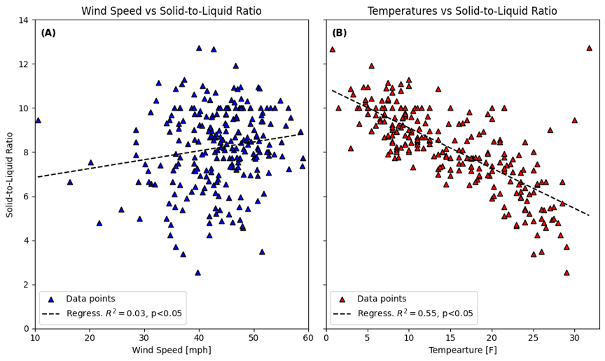
Assessing the correlation between Solid-to-Liquid Ratio and variables wind and temperature. It was found that SLR does not correlate significantly with wind and that SLR does correlate significantly with temperature.
For more information on SLR research, visit our Current Research Projects page.
Solid-to-Liquid Ratio (SLR) Research on Mount Washington
Tricia Hutton– SUNY Brockport, Meteorology & Earth Science
Observer Guide – Karl Philippoff
Intern Tricia Hutton analyzed solid-to-liquid ratios on Mount Washington for 2023. A solid-to-liquid ratio (SLR) is calculated by dividing the depth of solid accumulation by the depth of water measured after melting the solid precipitation (e.g. If you measured 1’’ of solid accumulation, and when melted, you measured 0.10’’ of liquid, the SLR would be 1’’/0.10’’ or 10:1). SLR varies by location and even over the course of a snowstorm at a single location according to different atmospheric parameters. Accurately estimating SLR is important for forecasting total snowfall accumulations, societal impacts, and avalanche conditions. Higher ratios are found in dry, ‘fluffy’ snow, which is liable to be blown around, while lower ratios produce wet, heavy snow and less blowing snow. The SLR of summit snowfall was compared with variations in temperatures, wind speed, and wind direction for this project.
A daily average was calculated each time solid precipitation was measured, and a 7-day running average was overlayed in red in Figure 1 below. For 2023, it was determined that the average value over this daily data is 10:1, slightly lower than the climatological average for the contiguous United States of 13:1.. Another quick look into my analysis includes the temperature relationship with SLR (see Figure 2). For 2023, the trend (red line) shows that as temperature increases SLR decreases, and is similar to the relationship seen at other stations. In the future, this research could refined and to incorporate data collected on Mount Washington since the 1930s.

Daily SLR versus Time for 2023. Each blue dot corresponds to a single day on which measurable solid and liquid precipitation were measured in 2023. The red line displayed is a 7-day running average of the daily data.

SLR vs. Temperature for each 6-hourly precipitation collection in which there was measurable solid and liquid precipitation compared with the average temperature of the same 6-hour period. Notice the lower SLRs measured as temperatures near the freezing mark, and the large variation, though higher mean value at lower temperatures.
For more information on SLR research, visit our Current Research Projects page.
How are Mid-Winter Thaws Changing at the Summit
Ethan Rogers – Penn State University, Meteorology
Observer Guide –Adam Gill
Mentor – Jay Claussen – Cold RegionsResearch and Engineering Laboratory, Hanover, NH
Skier and winter recreationalists dread those episodes of warm, rainy conditionsin the middle of winter. Furthermore, mountain ecosystems rely upon relatively consistent cold winters with a thick insulating snowpack.Recentresearch has examined how winter temperature and precipitation has changed in the Northeastwith a focus on the lower elevations. But weather and climate can vary substantially between the low elevations and the higher elevations of the Northeast. This research examines how “melt events” are changing at Mount Washington.
Intern Ethan Rogers studied how these melt events have evolved from 1935-2019. He examined four key metrics: 1) number of hours above 32F, 2) number of melt-degree-hours(the cumulative number of degrees above 32F each hour), and 3) the number each winter and 4) duration of melt events. He focused on melt events during the months that are climatologically below freezing: December-February.
Results revealed that although there is no significant change in the number of melt events each winter, they are becoming warmer and longer, especially in the last 40 years. The average number of melt-degree-hours per winter has nearly quadrupled from about 100 to nearly 400 over the 85-year period. The average number of hours above 32F has doubled from ~50 hours to just over 100 hours. Futureresearch will examine these same metrics using dewpoint temperature – which is a stronger indicator of melt.

The number of hours each winter (DJF) that were above freezing at the summit of Mount Washington from 1936-2019. The red line is a 10-year running average.
Does Mount Washington Weather Vary Consistently with the Dominant Large-Scale Atmospheric Pattern in the Region?
Emma Penafiel – John Hopkins University in Baltimore, Earth and Planetary Sciences
Observer Guide – Ryan Knapp
Mentors – Al Wheeler (retired National Weather Service), Mary Stampone (NH State Climatologist, UNH)
Mount Washington weather does not vary consistently with the El Nino-Southern Oscillation, which originates in the tropical Pacific Ocean. So does Mount Washington weather respond more consistently to other dominant large-scale patterns, such as the North Atlantic Oscillation (NAO)? The NAO describes the variability of the strength of the dominant pressure centers in the North Atlantic Ocean: the Icelandic Low and Azores High. For many low elevation sites in the Northeast US, a negative phase of the NAO often means colder and/or more snow because the jet stream dives south into the Mid-Atlantic region. A positive NAO often means warmer and/or rainy conditions as the jet stream retracts to the north. The NAO is a strong pattern during the cold season (November-March). In the warm season (April-October), the NAO becomes weak as the jet stream retracts toward the Arctic.
This research project correlated NAO phase with Mount Washington temperature and precipitation for the cold and warm seasons. Overall, there were not strong correlations for temperature or snowfall with the NAO when using the raw NAO index values; only up to ~6% of their variability was shared. However, these correlations became significant and strong (>65% of their variability was shared for the cold season) when the seasonal NAO index values were binned into 0.5-unit bins. The strongest correlation was for cold season temperature (76% variability shared) such that negative NAO values correspond with colder temperatures for the cold season. Improvements in seasonal forecasting of large scale patterns like the NAO will help improve local forecasts on Mount Washington and other locations. In addition, climate model projections of the NAO during the next 80 years will help inform decision-makers and planners when making business decisions and decisions about infrastructure and land-use.

A diagram showing the jet stream pattern and weather conditions associated with the negative (left) and positive (right) phases of the North Atlantic Oscillation pattern. The Icelandic Low (L) and Azores High (H) are weaker during the negative phase and stronger during the positive phase. Source: NOAA: https://www.climate.gov/sites/default/files/NAO_Schematic_0.png
Does it Matter Where on the Summit we Measure Temperature and Humidity?
Benjamin Charles –SUNY Oswego, Meteorology
Austin Patrick – Ohio University, Meteorology
Observer Guide – Ian Bailey
Mentor – Cathy Geiger(University of Delaware)
Observers have measured temperature and humidity every day since 1932 using a sling psychrometer. The exact location these measurements are taken have changed over the years whenever the Observatory location changed. But does it matter for the fidelity of ourclimate record?
Interns Ben Charles and Austin Patrick took the first step toward answering this question. They sought to determine whether or not the variability of and average temperature and humidity during a 5-minute period at multiple locations were different between sites. To do so, they first needed to see if the mobile instrument they were using (a handheld Kestrel 4000) is accurate enough to use for this study. They compared measurements from the Kestrel 4000 to the calibrated instruments at the summitby placing the instruments side-by-side for 5-minutes at a time during different times of day and under variable weather conditions. They also comparedtemperature, humidity and wind speedmeasurements from two Kestrel 4000 instruments to determine whether the Kestrel 4000 is accurate and precise enough to use for this research project.
Ben and Patrick analyzed data collected over three weeks and concluded that the two Kestrel 4000 instruments and the methods of taking the observations resulted invalues withlarge average and variability differences that make it an inappropriate mobile instrument for this particular study.Some changes in the methods for taking the measurements may account for some of the differences and will be explored in future research.

Interns Ben Charles (left) and Austin Patrick (right) sling Kestrel 4000 instruments alongside Observer Ian Bailey (center) making an official hourly temperature and humidity observation with a sling psychrometer.

