
Rime Ice Formation
2007-10-25 16:05:11.000 – Brian Clark, Observer

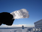
Chunk of ice
The picture you see attached to this comment was not taken today….unfortunately. It was taken on the Saturday of my last shift, October 13th. The summit had received a good coating of ice the night before, and then we cleared out of the fog just in time for a spectacular sunrise.
So why would I be showing you a picture of a piece of ice, taken nearly two weeks ago? Because you are looking at science in action my friends, that’s why.
The piece of ice you see me holding in my hand was attached to one of the flag poles in front of the Sherman Adams Building. Notice in the picture how the portion of the ice closest to my hand on the left side, is considerably more clear than the ice on the right. The left side of the piece of ice happened to be the side that was attached the flag pole and therefore formed first, with the whiter, more opaque ice forming later. Interestingly enough, I can actually use this to determine what the conditions were like and how they changed through the course of the ice formation.
This chunk of ice is defined more specifically as rime ice. Rime ice is simply frozen fog. When the air temperature drops below freezing, the tiny water droplets contained in the fog freeze onto any exposed objects, especially on objects facing into the wind. The clearer ice on the left is a particular type of rime ice called glaze ice, basically the same thing that forms when freezing rain falls. Glaze ice forms here on the summit when temperatures are close to the freezing mark. The ice is clear because the water droplets in the fog freeze rather slowly. On the other hand, regular rime ice, which is the whiter ice on the right, forms at lower temperatures. Unlike glaze ice, the water droplets that freeze to form rime ice freeze very quickly. This allows air to be trapped in the ice, giving it its white color.
Knowing this and looking at the pictured piece of ice, it is pretty clear that when ice first began to form, the temperature was near the freezing mark allowing the clear glaze ice layer to form. Later on, the temperature must have dropped several more degrees into the low to mid 20’s, allowing the rime ice to form on top of the glaze ice.
It’s pretty amazing what a simple chunk of ice on a flagpole can tell you when you look at it the right way.
Brian Clark, Observer

Seek the Peak 2026: New Adventures, Rooted in Tradition
Seek the Peak 2026: New Adventures, Rooted in Tradition By MWOBS Staff Seek the Peak is Mount Washington Observatory's largest annual fundraiser, and for 26 years it's brought together hikers, adventurers, and people who

What “Prepared” Really Means in the White Mountains
What “Prepared” Really Means in the White Mountains Early Spring in the Whites: The Most Honest Season By Andrew Harris, Burgeon Outdoor If you’ve spent any time in New Hampshire’s White Mountains in March,

March on Mount Washington
March on Mount Washington By Ryan Knapp Looking towards Mt. Madison at sunset on March 21, 2026. The calendar has spoken: Friday, 20 March 2026, marked the first day of astronomical spring.
