
Stability, Waves, and Wind
2007-01-30 09:33:33.000 – Neil Lareau, Observer

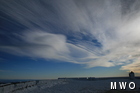
Wave Clouds
Winds this morning are higher than were expected; we’ve had a gust to 95 mph. This is significant in that it is about 20 below zero, and the wind does its best to instantly equalize the body’s heat with the surrounding atmosphere. Essentially this is what wind-chill values represent, the speed with which an exothermic body will lose heat. In trying to understand why our winds are so high we look to the temperature soundings for this morning (attained from balloon launches). It so happens that the vertical temperature profile of the atmosphere is actually very stable with an inversion layer from just below the summit to well above our elevation, the result of which is the impressive acceleration of otherwise moderate winds over the mountain (essentially the air is forced into an narrow accelerate slip just over the summit do to the unwillingness of the air above it to be displaced.) This scenario also allows for the vertical propagation of standing waves off of the entire range. At heights up to 22,000ft cirrocumulus and altocumulus lenticulars illustrate the oscillation of these waves. At lower elevations thin cap clouds mark the laminar flow of stable air over the summits and spindrift is visible in the turbulent eddies just down wind of some terrain features such as the rouche moutonneé of Mount Monroe.
Neil Lareau, Observer

Team Flags Return for Seek the Peak’s 25th Anniversary
Team Flags Return for Seek the Peak's 25th Anniversary By MWOBS Staff Mount Washington Observatory is looking forward to continuing a much-loved tradition for Seek the Peak’s 25th Anniversary: Team flags. In inviting teams
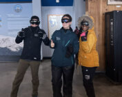
Meet Summer Interns Zakiya, Max and Maddie
Meet Summer Interns Zakiya, Max and Maddie By MWOBS Staff We are excited to welcome six teammates to the summit of Mount Washington this summer! During their internship, these students and graduates will play

Saying Goodbye to the Summit
Saying Goodbye to the Summit By Alexis George After an extraordinary last three years working as a Weather Observer and Meteorologist, I am excited to pursue a different career. As sad I as am
