
Talking about Turbulence
2016-09-17 17:02:22.000 – Tom Padham, Weather Observer/Meteorologist
While talking with intern Taylor a bit about the weather today, she brought up a simple, yet very complex question: why do we see wind gusts? The short answer is turbulence, but what makes the air and our wind turbulent gets more complicated.
We live beneath an ocean of air that makes up our atmosphere, with all of this air constantly flowing over the terrain features that make up the surface. Mountains, lakes, forests, fields, etc. are all constantly altering the air immediately above by often slowing it down due to the greater friction at the surface. This leads to a general increase in wind speed with height.
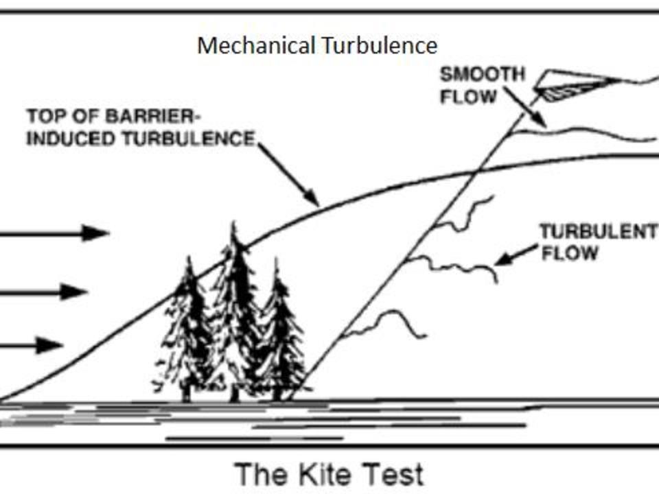 “The Kite Test” shows how turbulence from obstructions on the surface makes a kite fly erratically until a point where a more smooth flow takes over above the barrier. A good average height for this level is three times the height of the obstruction.
Turbulent, or chaotic motions of the air, are constantly occurring due to the air rising and sinking with the terrain (mechanical turbulence), and due to the ground being heated from the sun (convective turbulence). Since the atmosphere is almost transparent to incoming solar radiation, we heat pretty much from the ground up, but not equally! Different types of terrain and elevation differences lead to some areas like an open field or parking lot heating up more rapidly from the sun than say a lake or ice cap. This leads to thermals, or updrafts of relatively warmer air rising from the surface to higher elevations. What goes up must come down, and circulations of rising and sinking air (to varying degrees) form.
Bringing it all together, these rising and sinking air currents take what would otherwise be a steady flow of wind and mix everything up. Rising motions tend to lead to lulls in the wind speed at ground level, while sinking motions pull down the generally stronger winds seen aloft. When we see conditions that lead to very unstable air masses (during severe thunderstorms for example), very strong winds from several thousand feet up may be able to transfer momentum all the way to the surface resulting in very strong wind gusts. All of this chaotic mixing of the air makes meteorology a complex science; and forecasting the weather, especially on Mount Washington, no easy task!
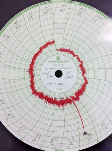
Hays Wind Chart June 9th, 2004 showing a 122 mph gust during a downburst event from a severe thunderstorm. That’s a lot of turbulence!
Tom Padham, Weather Observer/Meteorologist

Bringing Polar Byrd I to Mount Washington
Bringing Polar Byrd I to Mount Washington By Jackie Broccolo In 1968, my grandfather joined the Polar Byrd I “Dustin Transpolar Flight”, which was the first commercial flight to carry civilians across both poles

Seek the Peak 2026: New Adventures, Rooted in Tradition
Seek the Peak 2026: New Adventures, Rooted in Tradition By MWOBS Staff Seek the Peak is Mount Washington Observatory's largest annual fundraiser, and for 26 years it's brought together hikers, adventurers, and people who

What “Prepared” Really Means in the White Mountains
What “Prepared” Really Means in the White Mountains Early Spring in the Whites: The Most Honest Season By Andrew Harris, Burgeon Outdoor If you’ve spent any time in New Hampshire’s White Mountains in March,
