The Blizzard of 2015
2015-01-26 19:05:29.000 – Tom Padham, Weather Observer/Meteorologist
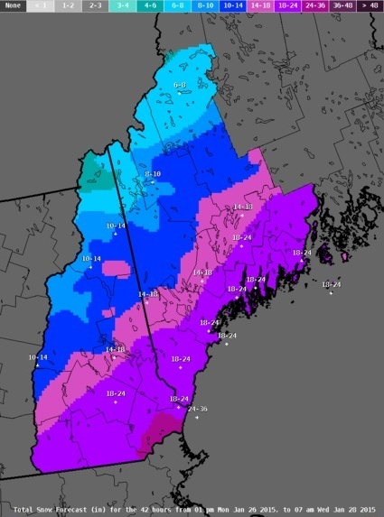
What a difference a week makes! It seems that after relatively little in the way of help from Mother Nature with snowfall so far this winter, things have turned around very quickly. After one major snowstorm dumped 6-12 inches of snow across southern parts of the state Saturday, a potentially historic Nor’easter is poised to drop anywhere from 1-3 feet of snow over nearly the entire state.
Snow will begin during the evening hours today across southern areas, with snow then spreading north towards the Canadian border after midnight. Snow will fall heavily at times through the day Tuesday, with the bulk of the heavy snow falling between Tuesday morning into Tuesday afternoon. White out conditions will be likely on the summit as winds jump up to sustained speeds of hurricane force with gusts possibly approaching 100mph Tuesday morning through the afternoon. The storm will be slowly weakening as it exits to the northeast, allowing for several more inches of snow to accumulate over the mountains overnight and into early Wednesday morning.
The summit will likely see 1-2 feet of snowfall, with very little of it remaining on the summit due to the high winds but sheltered areas will see some very impressive drifts, possibly exceeding 10 feet in places. The heaviest snowfall totals with this impressive blizzard will be over far southern New Hampshire and Massachusetts, where localized areas may see around 3 feet! Keep an eye on our current summit conditions page tomorrow to see how the storm unfolds!
 NWS Projected Snowfall Totals through 7AM Wednesday
Tom Padham, Weather Observer/Meteorologist
Team Flags Return for Seek the Peak’s 25th Anniversary
Team Flags Return for Seek the Peak's 25th Anniversary By MWOBS Staff Mount Washington Observatory is looking forward to continuing a much-loved tradition for Seek the Peak’s 25th Anniversary: Team flags. In inviting teams
Meet Summer Interns Zakiya, Max and Maddie
Meet Summer Interns Zakiya, Max and Maddie By MWOBS Staff We are excited to welcome six teammates to the summit of Mount Washington this summer! During their internship, these students and graduates will play
Saying Goodbye to the Summit
Saying Goodbye to the Summit By Alexis George After an extraordinary last three years working as a Weather Observer and Meteorologist, I am excited to pursue a different career. As sad I as am


