
The Challenge of Winter Storm QPF
2012-02-25 00:28:48.000 – Rick Giard, Weather Observer / Education Specialist
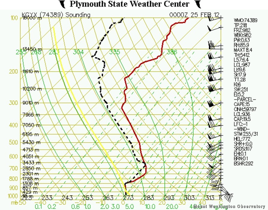
Sounding Via PSU Vortex
Anyone who spends much time outdoors in winter playing or working can tell you that snow, and frozen precipitation in general, comes in virtually infinite varieties. Each snow event occurs under slightly different conditions of temperature, humidity, winds, etc. Each frozen particle that forms takes on specific sizes, shapes and moisture content. Moreover, once that delicate snow crystal lands on a surface it immediately begins to change. Thus, one of the most challenging aspects of wintertime meteorology is QPF – the Quantitative Precipitation Forecast.
The exact amount of atmospheric water available is the first determining factor for QPF. One common measure (estimate) of this is Precipitable Water (PW), commonly obtained from radiosonde (weather balloon) data and recently through the Global Positioning System (GPS). Regardless of precipitation type a certain portion of the PW is theoretically available, although the exact amount that becomes precipitation depends on many other factors. During warm rainfall events it is generally not a concern whether the actual rain amount is 1.00 or 1.25 inches. However, snow (or any other type of frozen precipitation particle) varies greatly in actual water content. The ratio of snow accumulation to actual water content ranges from roughly 6 to as much as 30 inches per inch of Liquid Equivalent (LE), i.e. melted snow. If some sort of mixing occurs during the storm – changing to sleet or freezing rain, for example – accumulations are subsequently reduced even though the actual LE amount remained the same.
One important tool for determining whether changeover might occur is the sounding (shown). The atmospheric sounding is usually done by launching a balloon with instrumentation attached. This is done twice daily at National Weather Service (NWS) locations across the country. The most important data contained in the sounding include temperature, dew point, wind direction and speed. The temperature profile is critical for determining the possible precipitation type(s) that could occur. For example, if the temperature is cold throughout the atmosphere an all-snow event would be likely. Conversely, if warmer layers are present the potential for mixing or changeover exists. Hypothetically, if a deep warm layer is observed aloft while a shallow cold layer is seen at the surface, this would be a classic freezing-rain profile. It should also be noted that the sounding is a snap-shot in time over one place, and frequently changes as the storm travels across the region. For guidance in predicting how this will change, one must look to computer model generated soundings for your specific location, which are helpful but not completely reliable – especially in the complex White Mountain region!
So, when you see an outlook issued for “six to eight” inches of snow, please understand that this is an estimate based upon available information and subject to change and interpretation. Even the skilled and experienced forecaster occasionally will have a “busted” winter QPF prognostication. Through verification and post-analysis of forecasts, we learn more with each event.
Rick Giard, Weather Observer / Education Specialist

Seek the Peak Spotlight: The Cloud Chasers
Seek the Peak Spotlight: The Cloud Chasers By MWOBS Staff Mike Bergeron and Desiree Bolton have been participating and volunteering for Seek the Peak for three years now. Together, they comprise Team Cloud Chasers

Celebrating 250 Years: The Declaration’s Legacy in the White Mountains
Celebrating 250 Years: The Declaration's Legacy in the White Mountains By Peter Crane We are now approaching July Fourth, Independence Day, the day when we celebrate the adoption of the Declaration of Independence in

Seek the Peak Spotlight: Ryan Shepard
Seek the Peak Spotlight: Ryan Shepard By MWOBS Staff Before Ryan Shepard moved to Conway, he was in Western New York celebrating his 40th birthday party. “I wanted to go big,” he said. “Big”
