
The Deep Freeze is Here!
2019-01-10 10:45:46.000 – Tom Padham, Weather Observer/Education Specialist
We’ve had plenty of extremes so far this winter season on the summit of Mount Washington, from high winds to whiteout conditions and heavy snow, but one thing seems to be missing: extreme cold! Overall temperatures have been fairly mild (by our standards) since December, with our coldest temperatures actually occurring before the winter officially started in November at -26°F on the 22nd. December saw an average temperature of 11°F, slightly above average, and only saw -12°F as our coldest temperature to start the real winter season, pretty benign!
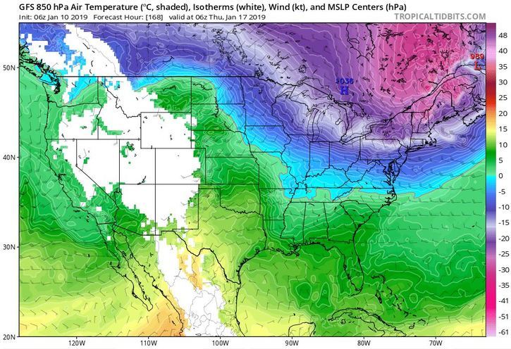
There looks to be some big changes on the horizon, however. After seeing a pretty big storm system the past several days carve out a new upper level trough it seems the pattern of having mild air across the East is coming to an end for now. Temperatures climbed to near freezing just ahead of the storm on the 8th and 9th, but now we’re approaching 0°F (with 13” of new snow and counting!). Much colder air will continue to pour into New England tonight and through the weekend, with temperatures likely bottoming out around -15°F sometime Saturday night. Winds will also be impressive during this time frame, potentially exceeding 120 mph, with wind chill values approaching -65°F.
This weekend may just be the “appetizer” for an even more impressive cold snap during the middle to late part of next week. An arctic cold front looks set to cross New England sometime Tuesday night through Thursday morning, with potentially the coldest air of this winter so far. Very cold air looks to be locked in place over Northeast Canada, and depending on the strength of the clipper/arctic front some of this frigid air may spill into northern New England by Thursday. This morning’s GFS model so far is the coldest, and would bring readings of near -30°F to the summit if it verifies. While I’m not always a huge fan of bitter cold, this would be another thing to check off the list so far this winter, and we always enjoy our extremes up here!
Tom Padham, Weather Observer/Education Specialist

Seek the Peak Spotlight: The Cloud Chasers
Seek the Peak Spotlight: The Cloud Chasers By MWOBS Staff Mike Bergeron and Desiree Bolton have been participating and volunteering for Seek the Peak for three years now. Together, they comprise Team Cloud Chasers

Celebrating 250 Years: The Declaration’s Legacy in the White Mountains
Celebrating 250 Years: The Declaration's Legacy in the White Mountains By Peter Crane We are now approaching July Fourth, Independence Day, the day when we celebrate the adoption of the Declaration of Independence in

Seek the Peak Spotlight: Ryan Shepard
Seek the Peak Spotlight: Ryan Shepard By MWOBS Staff Before Ryan Shepard moved to Conway, he was in Western New York celebrating his 40th birthday party. “I wanted to go big,” he said. “Big”
