The never-ending Cloud
2018-08-01 16:16:43.000 – Simon Wachholz, Summit Intern
The last observer comment discussed why Mount Washington has such strong winds. This post, on the other hand, will discuss why we’re so often in the clouds. I’m sure many of you who have visited the summit in the past have had similar experiences: you’re at the base of the mountain and it’s a beautiful, sunny day, but then you get up to the summit and suddenly its cloudy with a visibility of 50 feet. Oftentimes it seems like the summits are the only cloud in the Northeast, so what’s going on?
Clouds generally form through one of three different processes: radiative cooling, mixing, or uplift. All three processes are relatively common, and in all of them water vapor in the air condenses to form cloud droplets.
A prime example of clouds forming through radiative cooling is morning fog. When the air cools overnight, the temperature decreases, but the amount of water vapor in the air remains constant. As the temperature falls, it becomes easier for the water vapor to condense into a cloud. That’s why in the valleys fog is common in the early morning and then dissipates once the sun heats the surface up again.
The second process occurs when two different air masses mix with each other to create a cloud. One air mass has to be warm and moist while another has to be cool and dry. An example of this cloud is when you exhale on a cold day and you can see your breath – the warm air in your lungs mixes with the cold air outside to create a cloud. Another manmade mixing cloud occurs when you’re boiling water in a pot. This cloud is often mistaken as steam, but steam is actually invisible so what you see are just liquid cloud droplets.
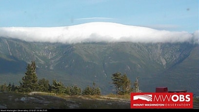
Getting back to why Mount Washington is so cloudy, the third type of cloud formation is from uplift, or rising air. When air rises, it cools the air to the point where the amount of water vapor in the air exceeds the saturation vapor pressure necessary for a cloud to form. Uplift occurs under several conditions. Perhaps one of the obvious ways to get rising air is when air flows up a mountain slope. Surprise, that’s what causes a lot of clouds to form around Mount Washington. This is the main reason why it can seem like a beautiful, sunny day in the valleys while the higher summits are immersed in clouds. A good example of this was on Monday morning when it was a sunny day in the valleys but Mount Washington was encased in a cap cloud with a thin lenticular cloud overhead.
 Webcam image from Wildcat looking towards Mount Washington Monday morning
Another type of uplift that isn’t topographically dependent occurs with thunderstorm formation. During the day, the sun heats the surface and the air near the surface. Since warm air is less dense than cool air, the air near the surface will become unstable and have a tendency to rise above the cooler air. If there’s enough vertical motion this can trigger clouds and eventually thunderstorm formation. Usually the summits are in the clouds when this happens so getting a decent view of cumulonimbus clouds isn’t possible. However, on Saturday conditions at the summit cleared while a thunderstorm passed to the Northwest.
So, if you visit the summit on a clear day consider yourself lucky enough to experience the incredible views of the White Mountains. Chances are though, you’ll visit on a cloudy day, but hopefully now you can appreciate being inside the cloud and why it never seems to dissipate.
Simon Wachholz, Summit Intern
Supporter Spotlight: Righteous Vices Coffee Roasters
Supporter Spotlight: Righteous Vices Coffee Roasters By MWOBS Staff Righteous Vices Coffee Roasters, a local coffee roaster and shop located in Center Conway, New Hampshire, has been a partner of the Observatory since 2024.
Winter Storm Tracks Across New Hampshire
Winter Storm Tracks Across New Hampshire By Alex Branton As winter comes to a close, most of us are ready for the warmer temperatures and sunshine that come with Spring and Summer. Although we
Bringing Polar Byrd I to Mount Washington
Bringing Polar Byrd I to Mount Washington By Jackie Broccolo In 1968, my grandfather joined the Polar Byrd I “Dustin Transpolar Flight”, which was the first commercial flight to carry civilians across both poles


