
The Pins Keep Falling…Throwing Strikes in Cyclone Alley
2015-02-12 22:10:43.000 – Nate Iannuccillo, Summit Intern
If you were to think of the northeastern US as a bowling alley and mid-latitude cyclones as the bowling balls, then we’re seeing one heck of a game this winter, because the storms keep hitting their mark. Today’s snow showers mark the latest mid-latitude cyclone to barrel through New England, and this trend shows no sign of letting up over the course of this next week.
Looking ahead, we are going to continue to see more snowfall contribute to this year’s record setting winter. Looking at the GFS (Global Forecast System) model runs for the upcoming week, we can see the potential for two storms on the horizon. One storm looks highly probable for Saturday night, and another potential nor’easter type storm for the following Wednesday.
Let’s take a look at the model outputs. Here is the outlook for 1AM in the morning on Sunday:
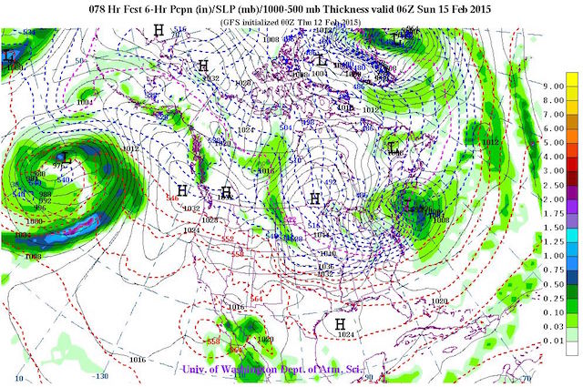 Image courtesy of the University of Washington Department of Atmospheric Sciences
And looking farther out, here is 7AM Wednesday morning:
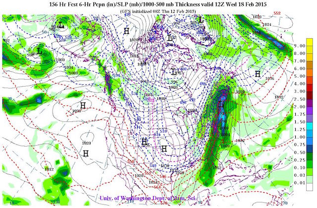 Image courtesy of the University of Washington Department of Atmospheric Sciences
Here, we see some potential for some serious snow depending on the track of this storm. Keep in mind that at this point, the uncertainty and error in the model run is quite a bit higher looking so far in the future. So the jury is still out on the exact track of this system, but I personally expect to see some snow coming from this.
I’ll end with some comments on the form of mid-latitude cyclones. To those unfamiliar with these types of systems, we are referring to centers of low pressure in the mid-latitudes (think continental US) that exhibit converging cyclonic rotation (counter-clockwise). They all have a similar structure, and the Norwegian Cyclone Model is a good visual to grasp the general structure of developing cyclones, and the shape of their associated warm and cold fronts moving across the North American continent.
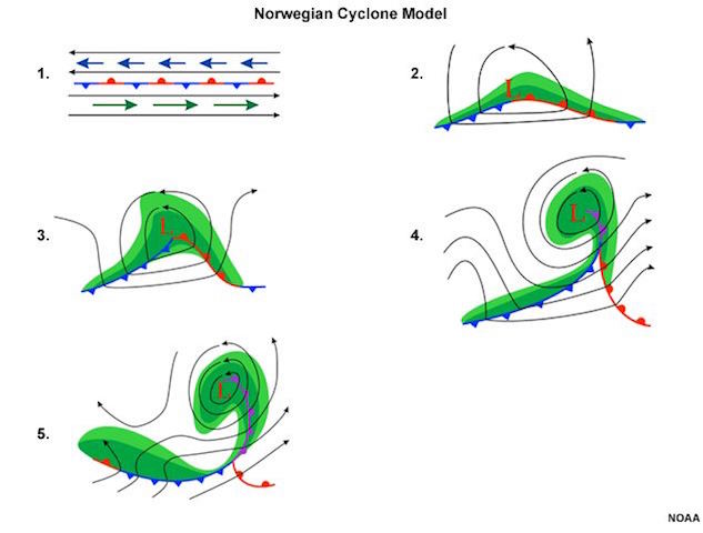 Image courtesy of the National Oceanic and Atmospheric Administration
The majority of our daily weather in New England is produced from systems similar to the image below. This visual below gives us a good idea of what type of weather we can expect in each area of the cyclone. Keep in mind that in the winter many of the “rain” sectors on the image bring snow instead.
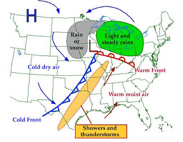 Image courtesy of the University of Illinois at Urbana Champaign Department of Atmospheric Sciences
More snow is in our future, so keep your snow shovels close and your skis closer!
Nate Iannuccillo, Summit Intern

Seek the Peak Spotlight: The Cloud Chasers
Seek the Peak Spotlight: The Cloud Chasers By MWOBS Staff Mike Bergeron and Desiree Bolton have been participating and volunteering for Seek the Peak for three years now. Together, they comprise Team Cloud Chasers

Celebrating 250 Years: The Declaration’s Legacy in the White Mountains
Celebrating 250 Years: The Declaration's Legacy in the White Mountains By Peter Crane We are now approaching July Fourth, Independence Day, the day when we celebrate the adoption of the Declaration of Independence in

Seek the Peak Spotlight: Ryan Shepard
Seek the Peak Spotlight: Ryan Shepard By MWOBS Staff Before Ryan Shepard moved to Conway, he was in Western New York celebrating his 40th birthday party. “I wanted to go big,” he said. “Big”
