The Polar Vortex, El Nino, and This Winter’s Outlook
2019-12-07 14:31:28.000 – Ian Bailey, Weather Observer/Education Specialist
Recently I did an interview with New Hampshire’s WNTK News-Talk radio that was a lot of fun! I spoke with Jason the interviewer at length about several “buzz word” terms you might hear quite often during the winter season, as well as what it is like living and working here on the summit during the winter time. If you have a second, you should give it a listen! >https://www.podbean.com/eu/pb-ixu5u-c91023 (You might have to download an app to listen as it is a podcast).
With the intent of the interview being to clear the air regarding the Polar Vortex, El Nino, etc. I felt as if a blog post addressing the same topic could be quite useful! So with the Northeast diving head-first into the Winter season, let’s take a second to discuss what exactly these terms are, how they relate, and what this year’s season could look like (as of current, at least).
A “Polar Vortex” really is just a large region of low pressure that swirls over the poles. Under normal atmospheric conditions, the rotation of this large low pressure region creates a Jet Stream, a high-velocity river of air high up in the atmosphere, that flows in a circular path completely around the planet. A Jet Stream then acts like a boundary between air masses; everything North of a jet stream is generally colder, and everything South of a Jet Stream is generally warmer, with “warmer” and “colder” being terms relative to where you are on the planet. As such, the air mass that is trapped over the North Pole by the polar Jet Stream has some very, very cold air associated with it. And when that really cold air wanders too far South, that’s when we get that buzzword “Polar Vortex Event”.
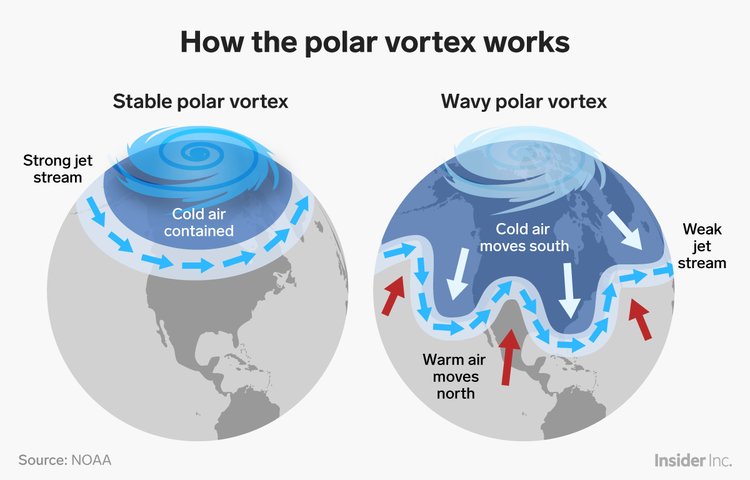
So what causes the weakening of the Vortex? Quite a number of things really, and probably a decent number of things we can’t even measure or account for yet. However, there are a few things we can account for. There have been recent studies published in the Bulletin of the American Meteorological Society and Nature that have found that melting sea ice in the Artic may play a big role (https://www.nature.com/articles/ncomms5646). Normally that sea ice can trap heat energy and stop it from being released back into the air, allowing for a greater contrast in temperatures between air masses, and allowing for strong winds. Less sea ice means more heat energy escaping into the atmosphere, less of a contrast in air mass temperatures and weaker polar jet stream winds, allowing cold air to dip further and further South. So that certainly can be one piece of the puzzle. And it can certainly be difficult to predict more than 10 days out, making forecasting for PVEs quite difficult.
What about El Nino? And is it related to PVEs in any way? Well, it’s definitely another piece of the puzzle. El Nino is a fluctuation of warm sea surface temperatures back and forth across the Pacific Ocean. When warmer water lies from the central Pacific to the Americas, that dictates what we call an El Nino weather pattern. And when the warmer water lies further West, near Asia and Australia, that dictates a La Nina weather pattern. 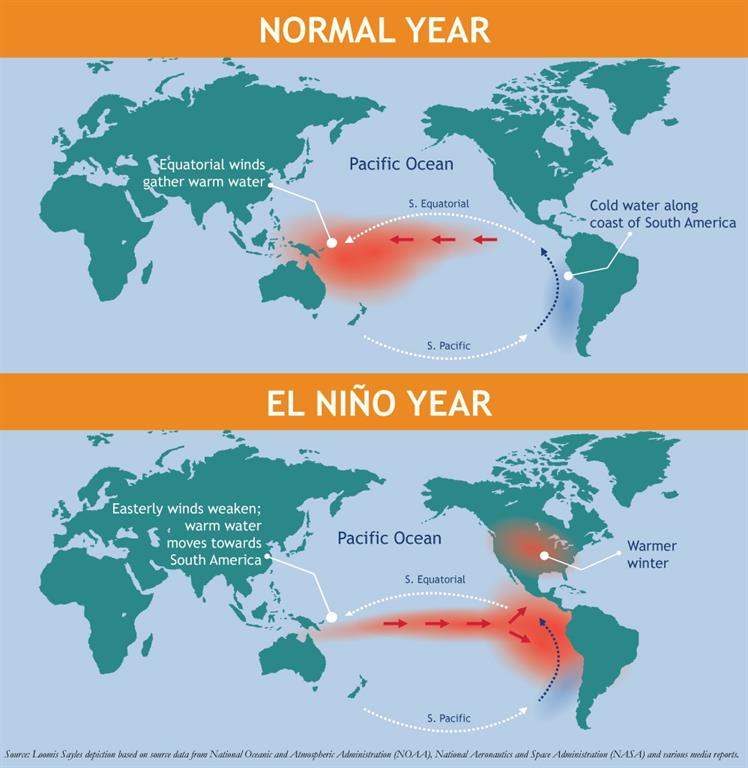
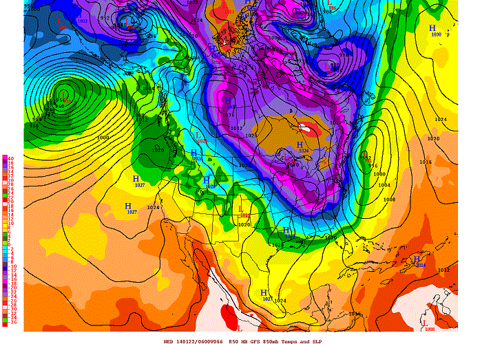
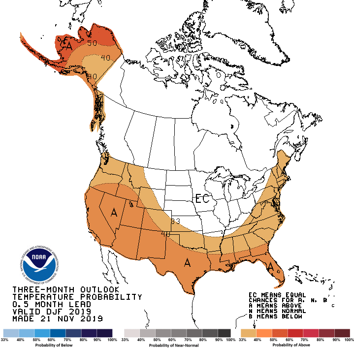
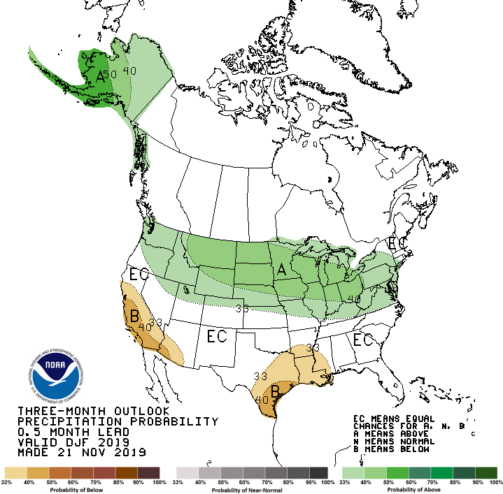
It has been difficult to predict things climatologically over the last few months, as climate models really haven’t had much agreement up until recently. As it stands currently, there has been a small dose of sudden stratospheric warming (SSW) over the past couple of weeks. And in turn, the PV has weakened a bit and will allow for some frigid temperatures to march South into the North/Central Plains and other parts of the Midwest for a couple of days next week. But models also agree that currently, the SSW doesn’t appear to be very strong or will be likely to grow any stronger, and will only provide the previously mentioned conditions intermittently for at most another week or so. After that, conditions will become similar to how they were last year. Ridging across the U.S. will actually allow for a fairly mild Winter across most of the country. The current 3-month outlook has most of the country experiencing slightly warmer than average temperatures, similar to last year. And with a neutral/weak El Nino climate outlook for the next 3 months, it’s unlikely that you’ll have the influence from that which would have weakened the polar vortex with any relative frequency. You can check out the Climate Prediction Center’s 3 month outlook below!
Phew! This has been a long post (and to be fair, I haven’t posted in a while), but I do love talking about this and helping educate people about the weather and other climatalogical forcings! If you ever have any questions, you can always reach out to us through email, social media, etc and we’re happy to chat! But hopefully you enjoyed this explanation, and I thank you for taking the time to read through! Until my next post, thank you all!
Ian Bailey, Weather Observer/Education Specialist
Winter Storm Tracks Across New Hampshire
Winter Storm Tracks Across New Hampshire By Alex Branton As winter comes to a close, most of us are ready for the warmer temperatures and sunshine that come with Spring and Summer. Although we
Bringing Polar Byrd I to Mount Washington
Bringing Polar Byrd I to Mount Washington By Jackie Broccolo In 1968, my grandfather joined the Polar Byrd I “Dustin Transpolar Flight”, which was the first commercial flight to carry civilians across both poles
Seek the Peak 2026: New Adventures, Rooted in Tradition
Seek the Peak 2026: New Adventures, Rooted in Tradition By MWOBS Staff Seek the Peak is Mount Washington Observatory's largest annual fundraiser, and for 26 years it's brought together hikers, adventurers, and people who

