
Two Feet of Powder
2013-02-10 18:32:25.000 – Mike Carmon, Weather Observer/Meteorologist

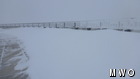
Deck Drifting
This weekend’s Nor’easter certainly did not disappoint.
While the massive snowstorm left behind some astronomically high snow totals (upwards of 40 inches) along coastal New England, originally, we were not expecting much on the summit.
Computer models had a hard time agreeing, as they usually do, on the exact path of this storm. Originally, it appeared as if we wouldn’t see too much of the white stuff up here on the summit–maybe a foot or so (still a decent mark, but nothing we’re not accustomed to). However, as the forecast morphed on Thursday, the day prior to the big event, it was looking more and more like we could end up seeing quite a bit more.
And that we did! Snow began on the summit at 8:40 PM EST on Thursday evening as the first of a duo of low pressure systems approached New England. The snow continued all night and through the entire day on Friday, dumping an average of three-quarters of an inch per hour, from 7AM Friday through 1AM Saturday.
At that point, though, the snow machine really kicked in, dumping approx. 6 inches or so in the six-hour period from 1AM through 7AM Saturday as heavy snow bands moved inland from the coastal storm. The effects of the mountain terrain definitely helped our cause as well, as snow continued on well into Saturday night, even though snowfall had concluded in valley locations around us. The last flakes wrapped up just after midnight on Sunday, making for a more-than-48-hour snowfall event.
All in all, we received a total of 24.5 inches of snow on the summit, which was in fact partially estimated, as winds howled in excess of hurricane force through the height of the storm, rendering our precipitation can virtually ineffective. However, having experienced the tremendous drifting during the night first hand, I have no doubt that our estimations are not an exaggeration at all.
Trudging through drifts up to my waist in an effort to collect the precipitation can twice during the night, with snow being whipped up into a blizzard that reduced visibility to about 10 feet or so at the Nor’easter’s apex, I had no doubt that Mt. Washington was in the midst of a significant snowfall event!
This was not an unprecedented event for us by any means, but it was still one to remember, particularly considering the bust-of-a-winter we experienced last year.
Mike Carmon, Weather Observer/Meteorologist
Three and a Half Months of Snow, Ice and Rime
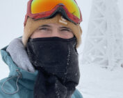
Three and a Half Months of Snow, Ice and Rime, with Deeper Drifts. By Ryan Steinke Me outside on the summit near the Yankee Building. My internship with the Mount Washington Observatory

Supporter Spotlight: Righteous Vices Coffee Roasters
Supporter Spotlight: Righteous Vices Coffee Roasters By MWOBS Staff Righteous Vices Coffee Roasters, a local coffee roaster and shop located in Center Conway, New Hampshire, has been a partner of the Observatory since 2024.
Winter Storm Tracks Across New Hampshire
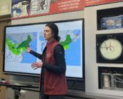
Winter Storm Tracks Across New Hampshire By Alex Branton As winter comes to a close, most of us are ready for the warmer temperatures and sunshine that come with Spring and Summer. Although we
