
Understanding Dew Point
2017-10-25 16:34:32.000 – Taylor Regan, Weather Observer
Every hour, on the hour, a weather observer atop the summit of Mount Washington steps outside and begins a weather observation. Sky cover, wind speed, visibility, temperature, dew point, all this information is gathered together and stored both in our records as well as sent off to the National Weather Service to be incorporated into weather models. While most of these variables are fairly self-explanatory, one of them requires a little further investigation. Can you guess which one I’m talking about? As a hint, it is largely responsible for the little droplets of water that cover the grass some mornings. That’s right! I’m talking about dew point!
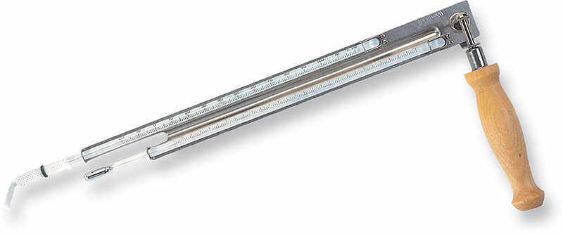
Figure 1. A sling psychrometer (above) measures wet and dry bulb temperatures to find the dew point of an air mass. (Image from forestry-suppliers.com)
So what is it exactly? Dew point is the temperature at which the air is saturated by water vapor. Essentially, it is the temperature at which the air cannot hold any additional water vapor, and a measure of the amount of moisture in the atmosphere. The National Weather Service defines dew point as “the temperature to which air must be cooled in order to reach saturation, assuming air pressure and moisture content are constant.”
Imagine, if you will, a box of air, of some constant dimension. Inside this box are many different things, oxygen, carbon dioxide, nitrogen, etc. There is also water vapor. Now, if the temperature of the box of air is increased, the air expands, and the box grows. At this point, you can fit more water vapor in the box. However, when the box cools, the air inside contracts, and the box shrinks; as a result, you are able to fit less water inside. So, how does this relate to dew point? The dew point is the temperature at which based on the amount of water vapor in the box, the box simply cannot hold any more water vapor. The air mass in the box is considered saturated, and at this point, fog forms.

Figure 2. Patriots playing football in heavy fog. (Image from espn.com)
An interesting real-world example of radiation fog (for that forms when the temperature drops to the dew point of the air mass) was at the most recent Patriots game. Still winds and a strong temperature inversion led to the perfect setup for a thick bank of fog to shroud the stadium. During the game, temperature at the surface was 59 degrees, but just 1200 feet into the atmosphere, it rose to 67 degrees. This inversion had a capping effect, meaning that the fog once it formed was not able to lift away. The fog itself occurred because of the rapid cooling on the surface. The air temperature at the stadium quickly cooled to the dew point for the given amount of moisture in the air, and as a result, the stadium was blanketed in thick fog. Pretty cool!
Taylor Regan, Weather Observer

Seek the Peak Spotlight: The Cloud Chasers
Seek the Peak Spotlight: The Cloud Chasers By MWOBS Staff Mike Bergeron and Desiree Bolton have been participating and volunteering for Seek the Peak for three years now. Together, they comprise Team Cloud Chasers

Celebrating 250 Years: The Declaration’s Legacy in the White Mountains
Celebrating 250 Years: The Declaration's Legacy in the White Mountains By Peter Crane We are now approaching July Fourth, Independence Day, the day when we celebrate the adoption of the Declaration of Independence in

Seek the Peak Spotlight: Ryan Shepard
Seek the Peak Spotlight: Ryan Shepard By MWOBS Staff Before Ryan Shepard moved to Conway, he was in Western New York celebrating his 40th birthday party. “I wanted to go big,” he said. “Big”
