Upslope Snow “Orographic Lifting”
2016-10-28 19:02:00.000 – Taylor Regan, Summit Intern
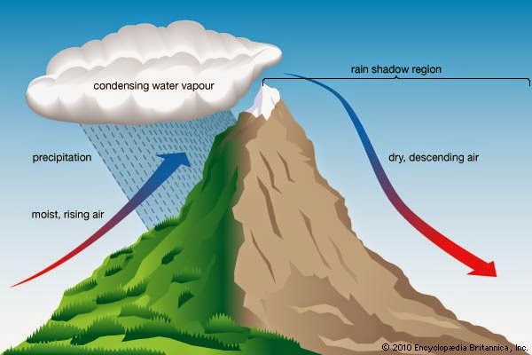
Imagine that you are hiking over the top of a mountain with a drinking cup that can change size. At the base of the mountain, the cup is maybe half full (or half empty, your call). As you climb the mountain, the cup shrinks, until the water completely fills the cup, but you still have further to go! Eventually, the cup has shrunk so much that some water spills out of the cup. If the cup were a parcel of air, this spillover would be upslope precipitation. As you descend the other side of the mountain, the cup gradually returns to its original size, but, because you lost some water on the way up, you are left with much less in the cup.
The White Mountains are uniquely situated perpendicular to the regional prevailing westerly winds, and with little in the way to break up the moving air mass, there are lots of opportunities to see upslope precipitation on the western slopes. However, upslope patterns (specifically upslope snow) are driven by three ingredients: moisture, low-level (surface) winds, and below freezing temps (for snow), and therefore, upslope patterns can develop on other faces of the mountains as well, as long as the “recipe” is met.
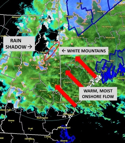
To the northwest of the Whites, as depicted in the above graphic, the precipitation is much lighter. The once moisture-rich air, having cooled and moved over the mountains, descends in a much drier state, as evidenced by the lack of precipitation being picked up on the radar. This “rain shadow” is a direct result of the forced upslope precipitation on the eastern edge of the Whites.
Taylor Regan, Summit Intern
Going with the Flow: Why New England Didn’t Experience Any Classic Nor’easters This Winter
Going with the Flow: Why New England Didn’t Experience Any Classic Nor’easters This Winter By Peter Edwards Why didn’t the Northeast experience any major snowstorms this year? If I had to guess, it’s the
A Look at The Big Wind and Measuring Extreme Winds At Mount Washington
A Look at The Big Wind and Measuring Extreme Winds at Mount Washington By Alexis George Ninety-one years ago on April 12th, Mount Washington Observatory recorded a world-record wind speed of 231 mph. While
MWOBS Weather Forecasts Expand Beyond the Higher Summits
MWOBS Weather Forecasts Expand Beyond the Higher Summits By Alex Branton One of the most utilized products provided by Mount Washington Observatory is the Higher Summits Forecast. This 48-hour forecast is written by MWOBS

