
Weekly Weather Summary January 22-28
2012-01-29 21:56:50.000 – Rick Giard, Weather Observer / Education Specialist
Weather 1/22-1/28
WEEKLY WEATHER SUMMARY
January 22-28
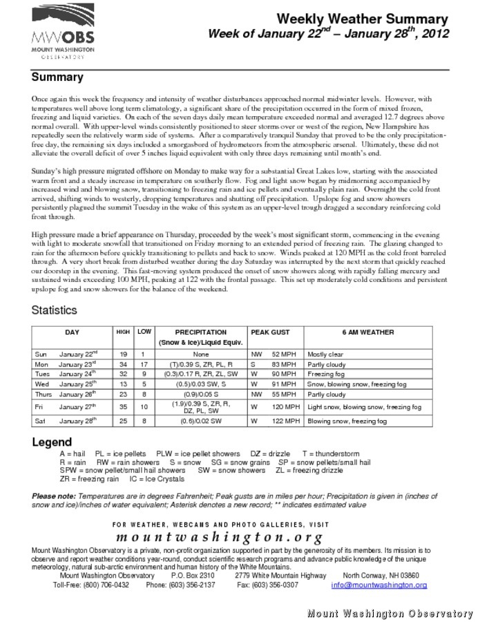
Once again this week the frequency and intensity of weather disturbances approached normal midwinter levels. However, with temperatures well above long term climatology, a significant share of the precipitation occurred in the form of mixed frozen, freezing and liquid varieties. On each of the seven days daily mean temperature exceeded normal and averaged 12.7 degrees above normal overall. With upper-level winds consistently positioned to steer storms over or west of the region, New Hampshire has repeatedly seen the relatively warm side of systems. After a comparatively tranquil Sunday that proved to be the only precipitation-free day, the remaining six days included a smorgasbord of hydrometeors from the atmospheric arsenal. Ultimately, these did not alleviate the overall deficit of over 5 inches liquid equivalent with only three days remaining until month’s end.
Sunday’s high pressure migrated offshore on Monday to make way for a substantial Great Lakes low, starting with the associated warm front and a steady increase in temperature on southerly flow. Fog and light snow began by midmorning accompanied by increased wind and blowing snow, transitioning to freezing rain and ice pellets and eventually plain rain. Overnight the cold front arrived, shifting winds to westerly, dropping temperatures and shutting off precipitation. Upslope fog and snow showers persistently plagued the summit Tuesday in the wake of this system as an upper-level trough dragged a secondary reinforcing cold front through.
High pressure made a brief appearance on Thursday, proceeded by the week’s most significant storm, commencing in the evening with light to moderate snowfall that transitioned on Friday morning to an extended period of freezing rain. The glazing changed to rain for the afternoon before quickly transitioning to pellets and back to snow. Winds peaked at 120 MPH as the cold front barreled through. A very short break from disturbed weather during the day Saturday was interrupted by the next storm that quickly reached our doorstep in the evening. This fast-moving system produced the onset of snow showers along with rapidly falling mercury and sustained winds exceeding 100 MPH, peaking at 122 with the frontal passage. This set up moderately cold conditions and persistent upslope fog and snow showers for the balance of the weekend.
For the complete Weekly Summary along with daily statistics, please click on the link above.
Rick Giard, Weather Observer / Education Specialist

Bringing Polar Byrd I to Mount Washington
Bringing Polar Byrd I to Mount Washington By Jackie Broccolo In 1968, my grandfather joined the Polar Byrd I “Dustin Transpolar Flight”, which was the first commercial flight to carry civilians across both poles

Seek the Peak 2026: New Adventures, Rooted in Tradition
Seek the Peak 2026: New Adventures, Rooted in Tradition By MWOBS Staff Seek the Peak is Mount Washington Observatory's largest annual fundraiser, and for 26 years it's brought together hikers, adventurers, and people who

What “Prepared” Really Means in the White Mountains
What “Prepared” Really Means in the White Mountains Early Spring in the Whites: The Most Honest Season By Andrew Harris, Burgeon Outdoor If you’ve spent any time in New Hampshire’s White Mountains in March,
