
Weekly Weather Summary Oct. 30 – Nov. 5
2011-11-06 20:20:42.000 – Rick Giard, Weather Observer / Education Specialist
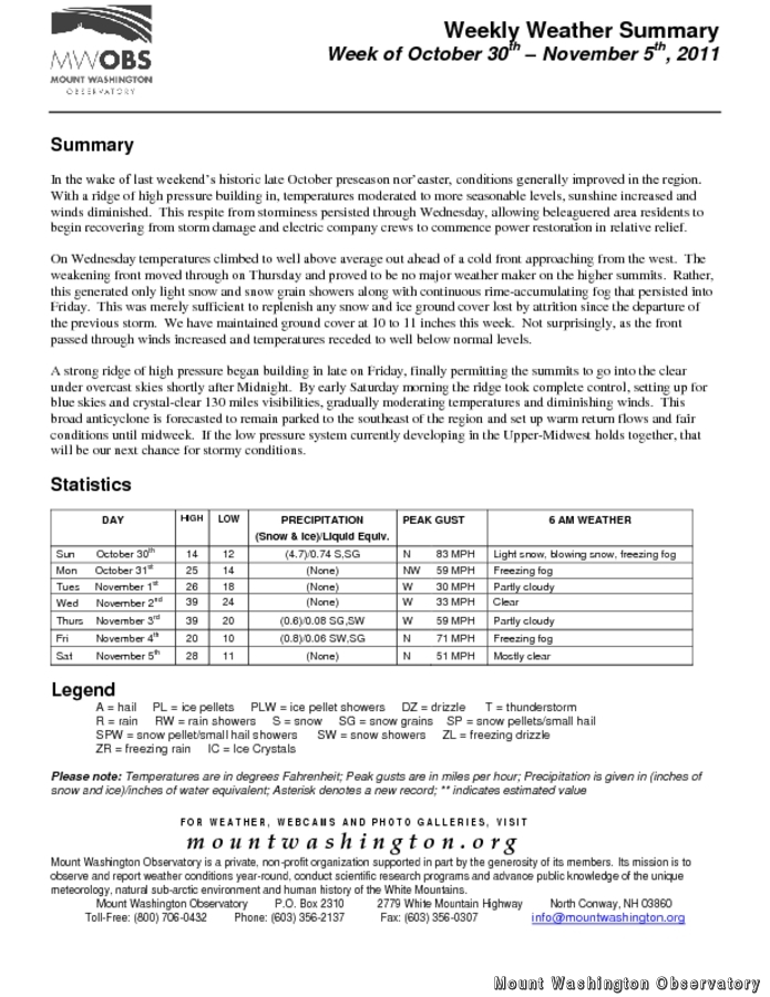
In the wake of last weekend’s historic October pre-season nor’easter, conditions generally improved in the region. With a ridge of high pressure building in, temperatures moderated to more seasonable levels, sunshine increased and winds diminished. This respite from storminess persisted through Wednesday, allowing beleaguered area residents to begin recovering from storm damage and electric company crews to commence power restoration in relative relief.
On Wednesday temperatures climbed to well above average out ahead of a cold front approaching from the west. The weakening front moved through on Thursday, but proved to be no major weather maker on the higher summits. Rather, this generated only light snow and snow grain showers along with continuous rime-accumulating fog that persisted into Friday. This was just sufficient to replenish any snow and ice ground cover lost by attrition since the departure of the previous storm. We have maintained ground cover at 10 to 11 inches this week. Not surprisingly, as the front passed through winds increased and temperatures receded to well below normal levels.
A strong ridge of high pressure began building in late on Friday, finally permitting the summits to go into the clear under overcast skies shortly after Midnight. By early Saturday morning the ridge took complete control, setting up for blue skies and crystal-clear 130 miles visibilities, gradually moderating temperatures and diminishing winds. This broad anticyclone is forecasted to remain parked to the southeast of the region and set up warm return flows and fair conditions until midweek. If the low pressure system currently developing in the Upper-Midwest holds together, that will be our next chance for stormy conditions.
To access the complete weekly weather summary, including daily statistics, please click on the link above.
Rick Giard, Weather Observer / Education Specialist

Three and a Half Months of Snow, Ice and Rime
Three and a Half Months of Snow, Ice and Rime, with Deeper Drifts. By Ryan Steinke Me outside on the summit near the Yankee Building. My internship with the Mount Washington Observatory

Supporter Spotlight: Righteous Vices Coffee Roasters
Supporter Spotlight: Righteous Vices Coffee Roasters By MWOBS Staff Righteous Vices Coffee Roasters, a local coffee roaster and shop located in Center Conway, New Hampshire, has been a partner of the Observatory since 2024.
Winter Storm Tracks Across New Hampshire
Winter Storm Tracks Across New Hampshire By Alex Branton As winter comes to a close, most of us are ready for the warmer temperatures and sunshine that come with Spring and Summer. Although we
