Weekly Weather Summary October 16-22
2011-10-23 17:40:07.000 – Rick Giard, Weather Observer / Education Specialist
Weather Summary Oct. 16-22
WEEKLY WEATHER SUMMARY
Week of October 16th – October 22nd, 2011
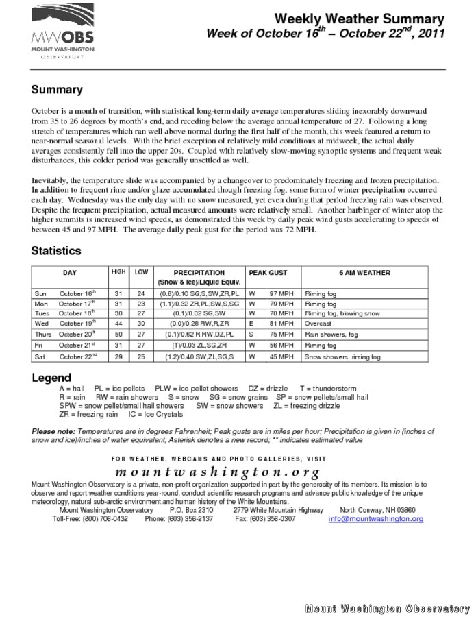
October is a month of transition, with statistical long-term daily average temperatures sliding inexorably downward from 35 to 26 degrees by month’s end, and receding below the average annual temperature of 27. Following a long stretch of temperatures which ran well above normal during the first half of the month, this week featured a return to near-normal seasonal levels. With the brief exception of relatively mild conditions at midweek, the actual daily averages consistently fell into the upper 20s. Coupled with relatively slow-moving synoptic systems and frequent weak disturbances, this colder period was generally unsettled as well.
Inevitably, the temperature slide was accompanied by a changeover to predominately freezing and frozen precipitation. In addition to frequent rime and/or glaze accumulated though freezing fog, some form of winter precipitation occurred each day. Wednesday was the only day with no snow measured, yet even during that period freezing rain was observed. Despite the frequent precipitation events, actual measured amounts were relatively small. Another harbinger of winter atop the higher summits is increased wind speeds, as demonstrated this week by daily peak wind gusts accelerating to speeds of between 45 and 97 MPH. The average daily peak gust for the period was 72 MPH.
To access the complete weekly weather summary, including daily statistics, please click on the link above.
Rick Giard, Weather Observer / Education Specialist
Supporter Spotlight: Righteous Vices Coffee Roasters
Supporter Spotlight: Righteous Vices Coffee Roasters By MWOBS Staff Righteous Vices Coffee Roasters, a local coffee roaster and shop located in Center Conway, New Hampshire, has been a partner of the Observatory since 2024.
Winter Storm Tracks Across New Hampshire
Winter Storm Tracks Across New Hampshire By Alex Branton As winter comes to a close, most of us are ready for the warmer temperatures and sunshine that come with Spring and Summer. Although we
Bringing Polar Byrd I to Mount Washington
Bringing Polar Byrd I to Mount Washington By Jackie Broccolo In 1968, my grandfather joined the Polar Byrd I “Dustin Transpolar Flight”, which was the first commercial flight to carry civilians across both poles


