
Weekly Weather Summary October 2nd – 8th, 2011
2011-10-10 15:08:01.000 – Rick Giard, Weather Observer / Education Specialist
Weather Summary Oct. 2-8
WEEKLY WEATHER SUMMARYOctober 2nd – 8th, 2011
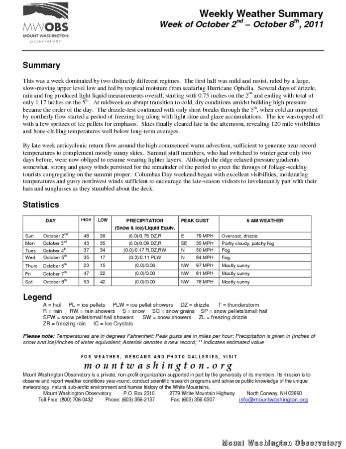
This was a week dominated by two distinctly different regimes. The first half was mild and moist, ruled by a large, slow-moving upper level low and fed by tropical moisture from seafaring Hurricane Ophelia. Several days of drizzle, rain and fog produced light liquid measurements overall, starting with 0.75 inches on the 2nd and ending with total of only 1.17 inches on the 5th.
At midweek an abrupt transition to cold, dry conditions amidst building high pressure became the order of the day. The drizzle-fest continued with only short breaks through the 5th, when cold air imported by northerly flow started a period of freezing fog along with light rime and glaze accumulations. The ice was topped off with a few spritzes of ice pellets for emphasis. Skies finally cleared late in the afternoon, revealing 120 mile visibilities and bone-chilling temperatures well below long-term averages.
By late week anti-cyclonic return flow around the high commenced warm advection, sufficient to generate near-record temperatures to complement mostly sunny skies. Summit staff members, who had switched to winter gear only two days before, were now obliged to resume wearing lighter layers. Although the ridge relaxed pressure gradients somewhat, strong and gusty winds persisted for the remainder of the period to greet the throngs of foliage-seeking tourists congregating on the summit proper.
Columbus Day weekend began with excellent visibilities, moderating temperatures and gusty northwest winds sufficient to encourage the late-season visitors to involuntarily part with their hats and sunglasses as they stumbled about the deck.
To access the complete weekly weather summary, including daily statistics, please click on the link above.
Rick Giard, Weather Observer / Education Specialist
Three and a Half Months of Snow, Ice and Rime
Three and a Half Months of Snow, Ice and Rime, with Deeper Drifts. By Ryan Steinke Me outside on the summit near the Yankee Building. My internship with the Mount Washington Observatory

Supporter Spotlight: Righteous Vices Coffee Roasters
Supporter Spotlight: Righteous Vices Coffee Roasters By MWOBS Staff Righteous Vices Coffee Roasters, a local coffee roaster and shop located in Center Conway, New Hampshire, has been a partner of the Observatory since 2024.
Winter Storm Tracks Across New Hampshire
Winter Storm Tracks Across New Hampshire By Alex Branton As winter comes to a close, most of us are ready for the warmer temperatures and sunshine that come with Spring and Summer. Although we
