Western Snow and a Look Ahead
2019-09-27 19:16:02.000 – Adam Gill, Weather Observer/IT Specialist
Watching the weather over the past few days and watching a snow storm of epic proportions forming in the front range of Montana. A large low pressure system will be forming in the lee of the Rocky Mountains will create several days of easterly flow in Montana, leading to heavy upslope snow in the Glacier National Park area. Below is an image from the National Weather Service in Great Falls MT, in regards to what they think the expected snowfall is. As a person who loves snow, I am very jealous of them. I cannot wait for the first snowflakes to start flying here.

This is an incredibly impressive early season storm for the Front Range though given the set up and the cold air in place I am not surprised. There is a strong easterly wind with deep moisture, so once that impacts the mountain range, the mountains will ring out the moisture as snow. If you are on the downward side of the mountain range, the warming and drying of the air as it goes down the mountain will lead to very little snow fall. Many valleys in Idaho and western Montana are expected to see very little snow out of this event due to down sloping. This is a cool set up since we experience upslope snow all the time in winter and can end up being a significant part of our annual snowfall.
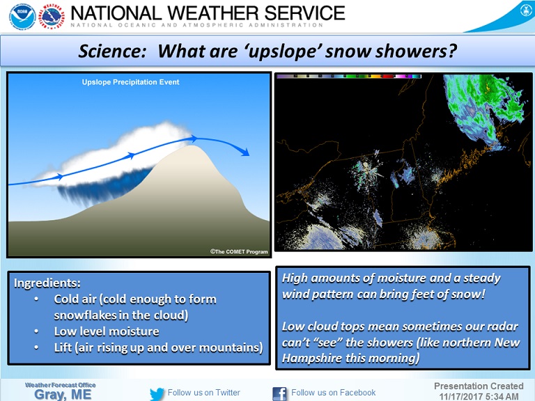
This also brings up an interesting misconception about measuring and predicting snowfall. Seeing 30-50 inches of snow in the forecast, many people imagine that at the end of the snow storm, there would be 30-50 inches of snow on the ground. This is very tough to attain, especially these high amounts early in the season. Snow is measured on a snow board every 6 hours in many locations so if you are getting 1 inch of snow per hour, you should receive about 6 inches on your snow board. That is cleared then put back on top of the snow for the next 6 hour period. In this period, the snow is still falling at 1 inch an hour so you measure another 6 inches of snow. The storm total is now up to 12 inches but when the total snow depth on the ground is measured, you have 9 inches. The reason for this would be compression of the snow. The weight of the new snow will be compressing the snow underneath it and result in a lower total snow depth.
For these early season snow, you have a warm ground as well as very wet heavy snow that will lead to both melting and quite a bit of compression so total snow depth after the snow storm is over will likely be less then what is forecasted. This happens a lot here on the east coast with Nor’Easters. Ahead of the Nor’Easter, we may receive cold, fluffy snow and as the low moves up the east coast, warmer more humid air will change the snow to a wetter, heavier type. This then compresses all the fluffy snow that initially fell resulting in less snow on the ground. Though snow storm totals from the snow board measurements every 6 hours may be quite close to what was forecasted.
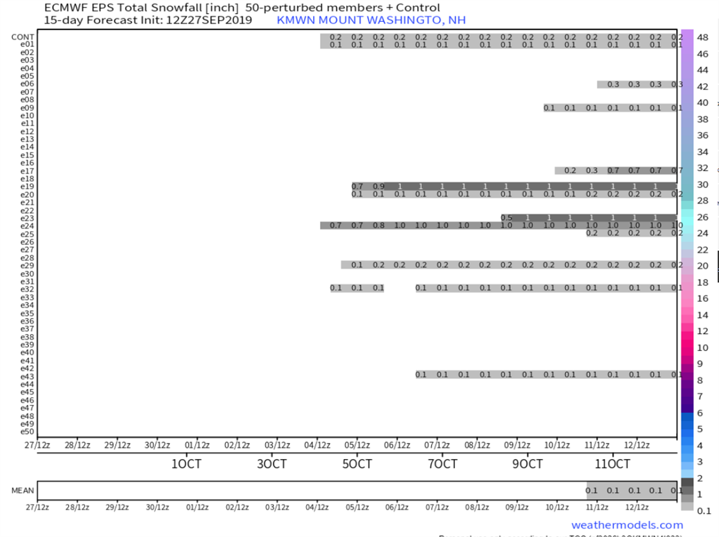
With snow falling in Montana, the question becomes when is it going to snow here? I wish I had better news for all you snow lovers out there because it does not look to occur any time in the next week or so. The storm system in Montana will bring more warm air into the eastern US while the storm itself heads up into the Hudson Bay area. We do have a few cold snaps with temperatures getting below freezing but the atmosphere is very dry so the odds of getting snow is pretty low. If we do end up getting any snow squeezed out of the systems, it will probably just be some flurries at most and not lead to any accumulation. Below is a plot of all the different European models and not too many have any accumulating snow which is never a great sign. Especially going out 15 days.
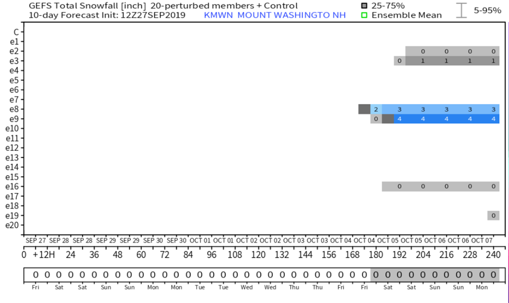
This is the GEFS which is an ensemble of the American models going out 10 days and a few have a couple of inches. The mean at the bottom still rounds to zero so confidence is very low.
Now of course at this time of year, especially with tropical systems in the Atlantic, we could see a sudden change in the forecast and result in a better chance of snow in the coming weeks and that is what I am hoping for. Right now all the models are in good agreement of cold, moisture starved air masses moving through but hopefully there will be a change in the weather pattern for the second half of October. That is too far out currently to have any idea of what is going to happen.
Adam Gill, Weather Observer/IT Specialist
Supporter Spotlight: Righteous Vices Coffee Roasters
Supporter Spotlight: Righteous Vices Coffee Roasters By MWOBS Staff Righteous Vices Coffee Roasters, a local coffee roaster and shop located in Center Conway, New Hampshire, has been a partner of the Observatory since 2024.
Winter Storm Tracks Across New Hampshire
Winter Storm Tracks Across New Hampshire By Alex Branton As winter comes to a close, most of us are ready for the warmer temperatures and sunshine that come with Spring and Summer. Although we
Bringing Polar Byrd I to Mount Washington
Bringing Polar Byrd I to Mount Washington By Jackie Broccolo In 1968, my grandfather joined the Polar Byrd I “Dustin Transpolar Flight”, which was the first commercial flight to carry civilians across both poles


