
What is a Cutoff Low?
2017-05-11 14:32:00.000 – Nathan Flinchbaugh, Summit Intern
It certainly has been a rather damp, dreary and cool start to the month of May over nearly the entire Northeast this year. The abundant rainfall has played a major role in helping the flowers bloom and the trees green up, and more than likely has resulted in the first grass cutting(s) of the warm season. But most people are growing tired of what seems to be an almost endless pattern of gray skies and cool temperatures. What’s been causing this long stretch of limited sunshine and unsettled weather?
The answer is a cutoff low. These unique systems have been plaguing forecasters forever, dubbing the phrase “cutoff low, weatherman’s woe.” Unfortunately, these are pretty common during springtime in New England, so you’ve probably at one point or another heard this term dropped. It more than likely also coincides with a time you were extremely annoyed with the weather.
Here in the westerlies, air that does not get interrupted by the friction from the land flows in a current from west to east. Inevitably, wrinkles in this west to east current develop, resulting in sharp troughs within the flow. Embedded in these troughs are areas of low pressure, responsible for foul weather. Occasionally, if a trough deepens enough, it will separate completely from the jet stream, forming a closed or cutoff low. This area of closed circulation becomes stationary and lonesome for potentially days on end, before eventually getting picked up by the jet stream again, and kicked out of its stationary position. Those unlucky enough to be under the influence of the cutoff low will experience cloudy, cool and damp weather for several days, until it gets returned back to the main flow. Those in New England were the unlucky ones this past week.
In order to pick these features out, meteorologists typically use “500 millibar charts.” This is an analysis of weather at approximately 18,000 feet in altitude, high enough in the atmosphere that the flow pattern is not affected by friction from the Earth’s surface.
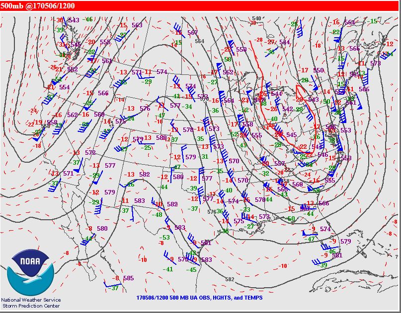
It all started with a deep trough over the Eastern Ohio Valley and a fast southerly flow in the upper levels above New England on Saturday morning (May 6).
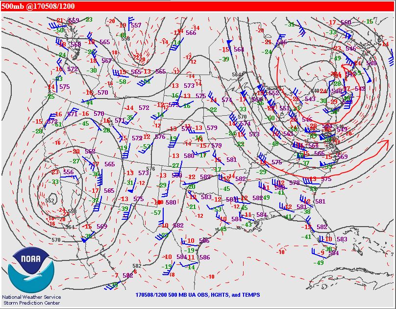
By Monday morning (May 8), the trough had been pushed east and the low had cut off from the main flow and was centered over the Northeast.
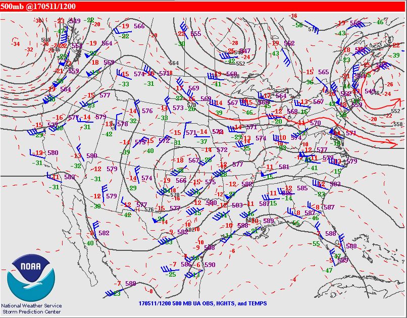
As of Wednesday morning (May 10), the cutoff low is still visible over much of New England.

Finally, as of Thursday morning (May 11), the cutoff low is still present, and had shifted east ever so slightly. This has resulted in some clearing across parts of Vermont, but thick cloud cover and a few showers remain over much of Maine.
Nathan Flinchbaugh, Summit Intern

Seek the Peak Spotlight: The Cloud Chasers
Seek the Peak Spotlight: The Cloud Chasers By MWOBS Staff Mike Bergeron and Desiree Bolton have been participating and volunteering for Seek the Peak for three years now. Together, they comprise Team Cloud Chasers

Celebrating 250 Years: The Declaration’s Legacy in the White Mountains
Celebrating 250 Years: The Declaration's Legacy in the White Mountains By Peter Crane We are now approaching July Fourth, Independence Day, the day when we celebrate the adoption of the Declaration of Independence in

Seek the Peak Spotlight: Ryan Shepard
Seek the Peak Spotlight: Ryan Shepard By MWOBS Staff Before Ryan Shepard moved to Conway, he was in Western New York celebrating his 40th birthday party. “I wanted to go big,” he said. “Big”
