
What is a Front?
2017-04-04 15:34:32.000 – Taylor Regan, Weather Observer
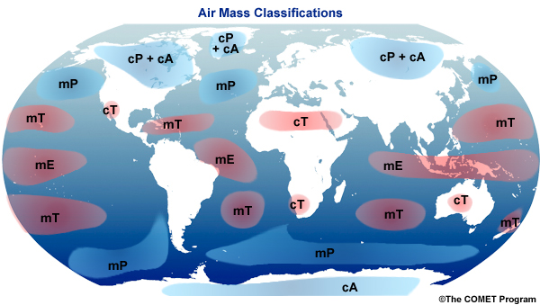
Large masses of air are continuously moving about on the surface of the Earth, driven largely by winds aloft, a horizontal pressure gradient, and the Coriolis Effect. The figure below depicts the various major air masses around the globe. The naming convention is as follows. The first letter (m or c) describes the moisture properties of the air mass, and indicates whether the air mass originated over water (maritime and moist) or land (continental and dry). The second letter indicates the thermal characteristics of where the air mass originated from. T = tropical, P = polar, A = arctic or Antarctic, and E = equatorial.
Fluids with different properties (such as density or temperature) do not like to mix. Oil and vinegar in a salad dressing highlight this point. Recall how the two fluids separate, and the oil floats atop the vinegar. Vigorous shaking reunites the two fluids, resulting in a relatively homogeneous dressing, but only for a short while. Air behaves in a similar manner. As a fluid, even a small difference in density is enough for the air masses to resist mixing.
Because the air masses dislike mixing, when they are forced to interact (for example, when one air mass “runs into” another) and have significantly different properties, the result is often some type of significant weather. A front, in terms of weather phenomena, is the boundary that separates two different air masses at the Earth’s surface, and is the cause for most of the weather seen outside of the tropics. These air masses typically have different densities, temperatures, and humidity.
There are four main types of fronts, which are named according to the temperature of the advancing air in relation to the temperature of the air it is replacing: warm, cold, stationary, and occluded. In the Northern Hemisphere, cold fronts and occluded fronts typically travel from the northwest to the southeast, while warm fronts typically move towards the poles (in the northern hemisphere, that means from the southwest to the northeast). On a surface weather map, fronts are depicted using colored triangles and half-circles, depending on the type of front. The figure below displays the colored notation for distinguishing between each type of front, with the line drawn on the map to indicate where the front is at the Earth’s surface.
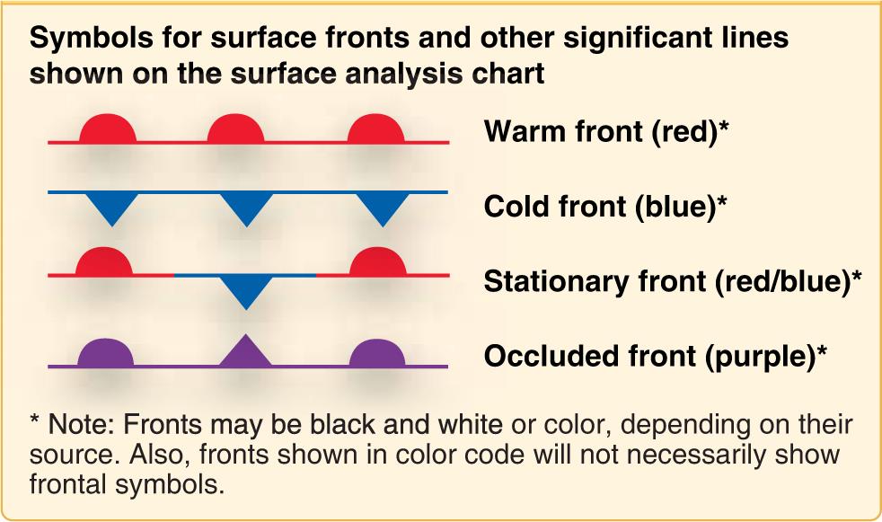
Figure 2. Symbolic representation of fronts.
Where two air masses collide, there is often turbulence, which is the typical cause of clouds and foul weather such as rain showers, or even more severe weather such as a tornado outbreak. The direction a front moves is typically guided by winds at higher elevations, such as jet streams. Interestingly however, large geographic features, like mountains and large bodies of water can also alter or slow the path of a front. An approaching front of any type always means changes to the weather are soon to be felt.
As I mentioned earlier, a front is named by the temperature air mass which is dominant, relative to the air mass it is replacing. In the case of a warm front, the warm air mass is moving into an area where cold air is in place, and is working to replace that cold air. This warm air slides over the top of the cooler air and gradually overtakes the region. Warm fronts are at the leading edge of a large mass of warm and often humid air. Typically, because the warm air slides over the top of the cold air in place, the passage of a warm front is preceded by fog and/or stratiform precipitation. In general, warm fronts are not as powerful as cold fronts, and typically move slower as well, this stems from the fact that cold air is denser and therefore more difficult to move. Warm fronts are known to bring longer lasting weather patterns than cold fronts, and are often associated with high-pressure systems.
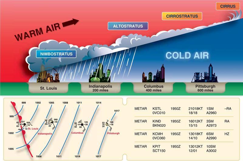
The figure below depicts the progress of a warm front across a region. Ahead of the warm front, high clouds will typically move in first, and they will generally be stratiform in nature, with rainfall increasing as the front moves in. This happens because as the warm, moist air is lifted, which causes the temperature to drop and condensation to occur. After the front has passed, the skies generally clear and the air warms relatively quickly. It should be noted however, that, if the warm air mass is particularly unstable, thunderstorms can be embedded in the incoming clouds, and persist even after the front has moved through.
Alternately, a cold front occurs when cold air squeezes through warmer, less-dense air, and lifts it. Due to the fact that air is being lifted, instead of pressed down, the process of a cold front moving through a warm front is typically called a low-pressure system. Because the air is ascending so rapidly, it forces the air temperature to decrease much more quickly, forcing the quick creation of clouds. Cold fronts often bring heavy thunderstorms, rain and hail, which can often be severe, and are located at the leading edge of a temperature drop-off. Because the cold air is “wedging” underneath the warm air at the surf ace, the strongest winds are typically just above the ground surface, with the cold air acting somewhat like a snowplow. Additionally, due to the speed with which a cold front is capable of moving through a warm air mass (up to twice as fast as a warm front), it typically produces narrower bands of thunderstorms that can be more intense than those of a warm front. The types of clouds that form at the frontal boundary depend on the stability of the warm air mass.
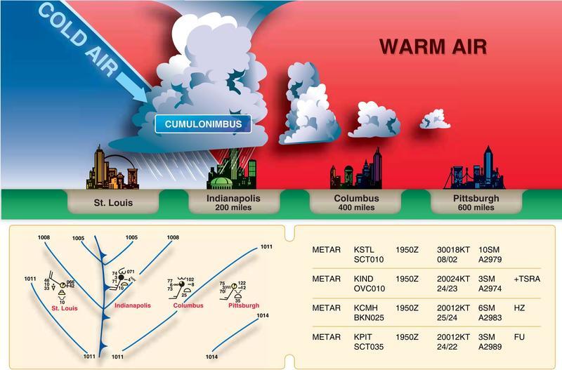
The figure below depicts the progress of a cold front across a region. Ahead of the cold front, relatively low clouds and haze will typically move in first. Because of the speed at which the warm air is lifted upward by the incoming cold air mass, clouds quickly develop, and can rapidly produce strong thunderstorms and heavy precipitation. After the front has passed, the skies generally clear and the air cools relatively quickly.
Taylor Regan, Weather Observer

Celebrating 250 Years: The Declaration’s Legacy in the White Mountains
Celebrating 250 Years: The Declaration's Legacy in the White Mountains By Peter Crane We are now approaching July Fourth, Independence Day, the day when we celebrate the adoption of the Declaration of Independence in

Seek the Peak Spotlight: Ryan Shepard
Seek the Peak Spotlight: Ryan Shepard By MWOBS Staff Before Ryan Shepard moved to Conway, he was in Western New York celebrating his 40th birthday party. “I wanted to go big,” he said. “Big”

From Florida Heat to the Rockpile
From Florida Heat to the Rockpile By Alek Libby Hi everyone! My name is Alek Libby, and I am one of the summit interns here at Mount Washington Observatory this summer! I recently graduated
