What’s up with this Heat?
2016-11-20 12:36:52.000 – Adam Gill, Weather Observer/IT Specialist
Both Friday and Saturday we set new record highs of 48 on Friday and then 49 on Saturday. The previous records for these dates were 46 on Friday (Set in 1958 and tied in 1994) and 45 on Saturday (Set in 1957 and tied in 1985). Both of these events we broke the previous records by multiple degrees which is an impressive margin, in fact Saturday broke the record by 4 degrees! Another interesting tidbit was that it was 48 degrees at midnight on Friday so we were already 3 degrees above the record high as soon as Saturday began!
What causes these temperatures to be so anomalously high? Well it was a combination of events that lead to the extreme warmth. One of the more interesting aspects of this warm event was the fact that we had north winds for almost the whole event with the winds shifting to the south on Saturday. When the winds did shift to the south, they were very light and with plenty of sun and temperatures already in the upper 40s, the temperature was able to nudge a few degrees warmer before temperatures finally started to fall.
It is quite uncommon to have warm air advection from the north like this in November. This is more common during the summer months when there is little snow cover to the north of us. This year, there has not been much snow that has fallen in Canada with most of the snow pack near and north of the Hudson Bay. The picture depicted below was the snow and ice cover on November 16th. The blue path is roughly the path the very warm air took to get to us. In the area within the black outline, there is almost no snow pack what so ever where normally there would be a decent amount of that area covered by snow. The soil in the upper Midwest into Canada is very dark and will absorb most of the incoming solar energy allowing the air to stay very warm even though it was advected well to the north. If there was snow cover, it would have reflected much of the incoming solar radiation back out into space and cooled the air above the snow.

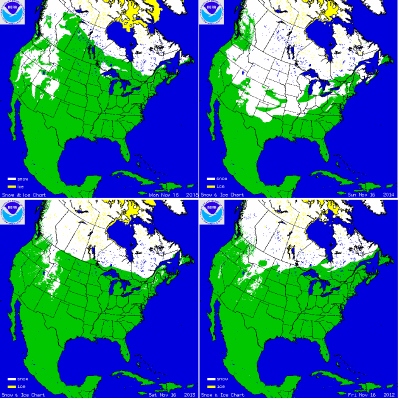
In the image below there is the snow cover for November 16th in 2015, 2014, 2013, and 2012. In each of these years there is at least a little bit of snow in the area north of the Great Lakes and south of Hudson Bay that helped cool the warm air was advected into the region. Last year there was not much snow at all as well and November 2015 was one of our warmest. This year is on its way to be one of the warmest Novembers as well but there looks to be a pattern shift that will keep things much cooler in the short term. In 2014, the US had a very extensive snow cover and that November 2014 ended up being well below average.


Looking into the next week, the colder weather pattern is looking to take a stronger hold. There could be a few small clipper systems that could drop a few inches of snow each over the next week here in the White Mountains. Temperatures over the higher summits will likely stay below freezing so there won’t be too much snow melt. In the image below, this is the expected snowfall over the next 180 hours from 7 am this morning to 7 am on November 28th. There is going to be quite a bit of new snow Canada and will hopefully become part of the permanent snow pack! Hopefully we have finally gone more into a long term winter pattern here in the North East to keep the snow coming!

Image is from Pivitol Weather
Adam Gill, Weather Observer/IT Specialist
Three and a Half Months of Snow, Ice and Rime
Three and a Half Months of Snow, Ice and Rime, with Deeper Drifts. By Ryan Steinke Me outside on the summit near the Yankee Building. My internship with the Mount Washington Observatory
Supporter Spotlight: Righteous Vices Coffee Roasters
Supporter Spotlight: Righteous Vices Coffee Roasters By MWOBS Staff Righteous Vices Coffee Roasters, a local coffee roaster and shop located in Center Conway, New Hampshire, has been a partner of the Observatory since 2024.
Winter Storm Tracks Across New Hampshire
Winter Storm Tracks Across New Hampshire By Alex Branton As winter comes to a close, most of us are ready for the warmer temperatures and sunshine that come with Spring and Summer. Although we


