
Wind Chill Advisory VS Warning
2018-02-15 10:36:20.000 – Jillian Reynolds, Summit Intern
You may have heard or seen in our forecasts that a “Wind Chill Advisory/Warning is in effect until…” After hearing or seeing those alerts, you may think “what exactly does that mean?” I will explain the differences in criteria between both. But first, what is ‘wind chill’?
The National Weather Service (NWS) defines wind chill as “the rate of heat loss from the human body”. The combination of cool temperatures and wind creates wind chill. As the winds increase, heat is driven away from the body at a faster rate, as both the skin temperature and eventually the internal body temperature decrease.
When calculating wind chill up here on the mountain, we like to use the NWS’ wind chill chart (shown below). This chart helps us visualize what the potential range of wind chill would be, as well as the amount of time it would take for someone to receive frostbite.
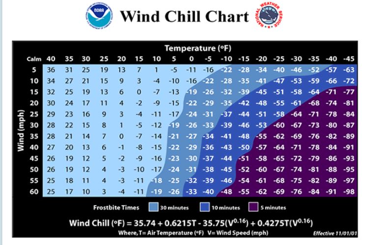
For the summit of Mount Washington, if the wind chill is between 35 and 50 degrees Fahrenheit below zero, a wind chill advisory will be issued. According to the chart above, one could expect to get frostbite within 10 minutes if there is any exposed skin.
If the wind chill is any less than 50 degrees Fahrenheit below zero on the summit, then a wind chill warning will be issued. The NWS Wind Chill Chart shows that you could get frostbite within 5 minutes if there is any visible skin.
The colder the wind chill is, the greater your risk of obtaining hypothermia is. If you or your clothes are wet, hypothermia will become even more likely.
For both alerts, it is important that you stay dry, stay covered, dress in layers, and stay informed. If you plan on hiking up to the summit, always check out our forecasts first on our website (https://www.mountwashington.org/experience-the-weather/higher-summit-forecast.aspx). That way, you will know how to prepare for your ascent!
Jillian Reynolds, Summit Intern

Seek the Peak 2026: New Adventures, Rooted in Tradition
Seek the Peak 2026: New Adventures, Rooted in Tradition By MWOBS Staff Seek the Peak is Mount Washington Observatory's largest annual fundraiser, and for 26 years it's brought together hikers, adventurers, and people who

What “Prepared” Really Means in the White Mountains
What “Prepared” Really Means in the White Mountains Early Spring in the Whites: The Most Honest Season By Andrew Harris, Burgeon Outdoor If you’ve spent any time in New Hampshire’s White Mountains in March,

March on Mount Washington
March on Mount Washington By Ryan Knapp Looking towards Mt. Madison at sunset on March 21, 2026. The calendar has spoken: Friday, 20 March 2026, marked the first day of astronomical spring.
