
Wind, Lightning, And A Rainbow
2013-06-23 22:05:08.000 – Ryan Knapp, Weather Observer/Meteorologist

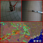
Microburst from this afternoon’s thunderstorm.
It was an active afternoon of weather to say the least. A cold front sweeping through brought a line of thunderstorms to the state providing heavy rain, large hail, high winds, and continuous lightning. As far as the summit is concerned, we received three out of the four elements as the line swept through. First came the rain. It started slow then picked up in intensity until it started falling heavily. As rain ramped up, the lightning came next. Again, it started slowly; a flash here, a rumble there with several minutes passing after each element. But then the spacing of flashes and rumbles narrowed down to just seconds between each flash/bang. Then as the core of the storm passed, a downdraft in the form of a microburst swept across the peaks. Winds were already averaging 30-40 mph but as the microburst hit us, winds gusted up to 76 mph, lasting only a matter of minutes before backing to 30-40 mph after the line passed. This can be seen in the thumbnail image to this comment – the top left is the wind chart and the top right is our pressure chart with the thunderstorm line in the bottom half.
As the storm started to wind down, we started to clear from the fog a bit. So I decided to set up my dSLR in the weather room in hopes of photographing a strike of lightning. I lowered the aperture to f22, lowered the ISO to 100, and did consecutive 1 second exposure’s by use of an intervalometer. While a shorter exposure is more ideal, the variability of light with the passing clouds, made it difficult to get things just right. So, one second was the best middle ground length. After waiting a few minutes, we saw the flash and heard the thunder at the same time and new that something on the summit had received a direct hit. When things finally died down, I took the card out and after sorting through 243 images, I found the ‘money shot’ with a direct hit to the antenna positioned just to the west of our weather room window. While the image wasn’t 100% crisp due to rain running down the window and the exposure length washing things out a bit, it still ended up being an awesome capture; and one that I have been wanting to photograph for several years now.
But the day wasn’t through yet. As the line of thunderstorms moved out, we briefly cleared on and above the summits allowing for the sun to shine from the west towards the east. Anyone with knowledge about optics knows that sunlight to your back and rain falling to your front makes for a rainbow. So, after grabbing the trusty camera one more time, I ran out to find a double rainbow stretching across the summit. It only lasted a matter of minutes before the clouds rolled back in. But in that brief moment, it provided a colorful scene and terrific end to a dynamic afternoon.
Ryan Knapp, Weather Observer/Meteorologist

Seek the Peak Spotlight: The Cloud Chasers
Seek the Peak Spotlight: The Cloud Chasers By MWOBS Staff Mike Bergeron and Desiree Bolton have been participating and volunteering for Seek the Peak for three years now. Together, they comprise Team Cloud Chasers

Celebrating 250 Years: The Declaration’s Legacy in the White Mountains
Celebrating 250 Years: The Declaration's Legacy in the White Mountains By Peter Crane We are now approaching July Fourth, Independence Day, the day when we celebrate the adoption of the Declaration of Independence in

Seek the Peak Spotlight: Ryan Shepard
Seek the Peak Spotlight: Ryan Shepard By MWOBS Staff Before Ryan Shepard moved to Conway, he was in Western New York celebrating his 40th birthday party. “I wanted to go big,” he said. “Big”
