Winter on the Way!
2012-12-15 17:44:55.000 – Brian Fitzgerald, Weather Observer/Education Specialist
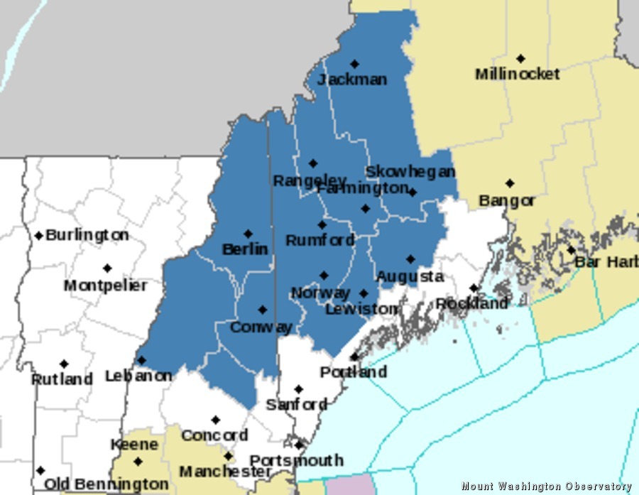
Winter Storm Watch ares in blue. Courtesy NWS.
Winter doesn’t officially begin in the Northern Hemisphere until Friday the 21st– though here on the Rockpile we’ve been seeing a taste since October. Lucky for us, and now lucky for the valley, we’ll be seeing our first significant winter storm enter the region late in the afternoon on Sunday with the bulk of the precipitation falling as snow for interior and Northern New Hampshire, Vermont and Maine starting Sunday night and early Monday morning, with lighter accumulations occurring straight through to Tuesday morning. Snow will likely linger on the higher summits beyond Tuesday morning, and perhaps in the valleys too (though perhaps changing to rain, sleet or freezing rain), as we closely watch a parade of systems starting to appear in our models.
On this morning’s radio shows I was more than happy to state: the National Weather Service (click for detailed information from our regional NWS office) has issued a Winter Storm Watch this morning taking effect Sunday afternoon lasting through Tuesday morning. My excitement is due in part to the fact that right now as we speak, the summit of Mount Washington has only about 1 inch of snow, rime and ice on the ground with areas of deeper drifts. After November’s major dry spell, December has been well onto its way of being a big repeat. The monthly average for December calls for 8.84 inches of liquid (be that from snow, rain, sleet, etc), and 50 inches of snow. As of the half-way point of the month we have received 2.21 inches of liquid and an even more measly 5.9 inches of snow. So you could say we have some catching up to do– and hopefully with by the end of next week we’ll be in more typical December standings. So for now, enjoy the snow and be safe out there!
Brian Fitzgerald, Weather Observer/Education Specialist
Three and a Half Months of Snow, Ice and Rime
Three and a Half Months of Snow, Ice and Rime, with Deeper Drifts. By Ryan Steinke Me outside on the summit near the Yankee Building. My internship with the Mount Washington Observatory
Supporter Spotlight: Righteous Vices Coffee Roasters
Supporter Spotlight: Righteous Vices Coffee Roasters By MWOBS Staff Righteous Vices Coffee Roasters, a local coffee roaster and shop located in Center Conway, New Hampshire, has been a partner of the Observatory since 2024.
Winter Storm Tracks Across New Hampshire
Winter Storm Tracks Across New Hampshire By Alex Branton As winter comes to a close, most of us are ready for the warmer temperatures and sunshine that come with Spring and Summer. Although we


