Winter Precipitation
2018-01-02 15:55:01.000 – Taylor Regan, Weather Observer
With the recent Christmas storm fresh on many minds, and with more winter weather on the way, I wanted to take a look at some of the differences in precipitation type that can occur when the mercury drops to or even below freezing. The differences between rain and snow are fairly well known, but what about sleet or freezing rain? Knowing which type of precipitation is falling can clue you in on the overall state of the atmosphere around you, which is pretty neat!
In this blog post, I’ll cover four types of precipitation common in winter-season storms, especially in New England: rain, freezing rain, sleet, and snow. If you’re wondering, yes, there is a reason I listed them in that order, and it has to do with the quantity of freezing air in place overhead.
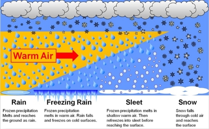
 Figure 1. Diagram depicting precipitation type in varying air temperatures. (Image from www.weather.gov/rnk/measure_icing)Caption text
Rain occurs when there is a large volume of above-freezing air overhead (the air is warmer than 32 degrees). Precipitation may start off as snow, but it melts as it falls through a warm layer, which extends all the way to the ground.
Freezing rain occurs when precipitation, which may start as snow, passes through a warm (above freezing) layer, and melts, turning to rain. At the surface, however, is a shallow pool of below-freezing air that, while not enough to cause the raindrops to refreeze prior to reaching the ground, means that they freeze instantly upon contact with anything that is at or colder than 32 degrees. This can cause significant ice accumulations on everything from power lines to trees to vehicles.
Sleet occurs when precipitation, falling as snow, passes through a shallow warm (above 32 degrees) layer, causing the snowflakes to partially melt. The partially melted snowflakes then pass through a deep cold layer, causing them to refreeze, but lacking their initial definition and form as snowflakes.
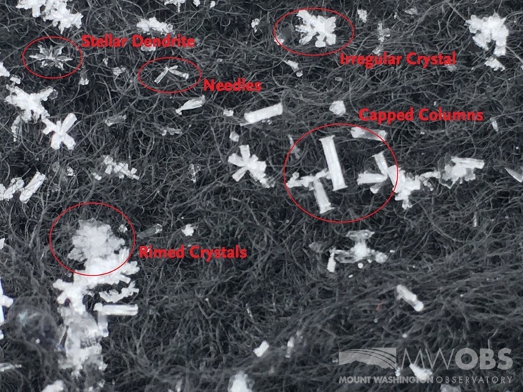
When the temperature is below freezing all the way from the cloud to the ground, it snows! Snowflakes can come in a variety of shapes and sizes, and no two are the same! Stellar Dendrites are the most recognizable snow crystals, but you can see in the image below some of the other types of snowflakes that can occur.
 Figure 2. Various types of snowflakes seen on the summit.
Taylor Regan, Weather Observer
Seek the Peak Spotlight: Sandy and Joan Kurtz
Seek the Peak Spotlight: Sandy and Joan Kurtz By MWOBS Staff Sandy and Joan Kurtz have been active supporters of Mount Washington Observatory for almost five decades. After visiting North Conway in 1980, they
Living the Night Life
Living the Night Life By Madelynn Smith My alarm goes off in the bunkroom, with blackout curtains obscuring the sun’s rays as it begins to lower in the sky. My day starts in the
Three and a Half Months of Snow, Ice and Rime
Three and a Half Months of Snow, Ice and Rime, with Deeper Drifts. By Ryan Steinke Me outside on the summit near the Yankee Building. My internship with the Mount Washington Observatory


