
Recent Ice Storm
2019-10-29 19:51:32.000 – Adam Gill, Weather Observer/IT Specialist
This past weekend we ended up getting a pretty good ice storm up here on the summit. We were originally expecting to get some snow or sleet initially before transitioning to rain in the afternoon. I was on morning observations during the beginning of the storm and was outside when the precipitation first began. The air temperature was 23 degrees so with the line of precipitation moving in, I was waiting for the first snowflakes to start coming down. Instead, I was hit by several drops of rain. I waited to see if it would transition to sleet as the rain got heavier but alas, it stayed all liquid.
The inversion ended up being just above summit level for the entire day with temperatures only getting up to near 28 during the bulk of the precipitation. We did not get above freezing until after sunset and it was a sharp increase in temperature, jumping almost 6 degrees in one hour. Here is the temperature profile from the Gray Maine weather balloon launch Sunday. There is a distinctive warm later aloft, right at about 7000 feet. It also explains why we had such a sharp increase in temperature once the inversion mixed down to summit level.

It was an impressive amount of glaze ice that developed from the freezing rain. I have seen a few larger events than this one. If the winds were stronger with this event, ice accumulations would have been higher.
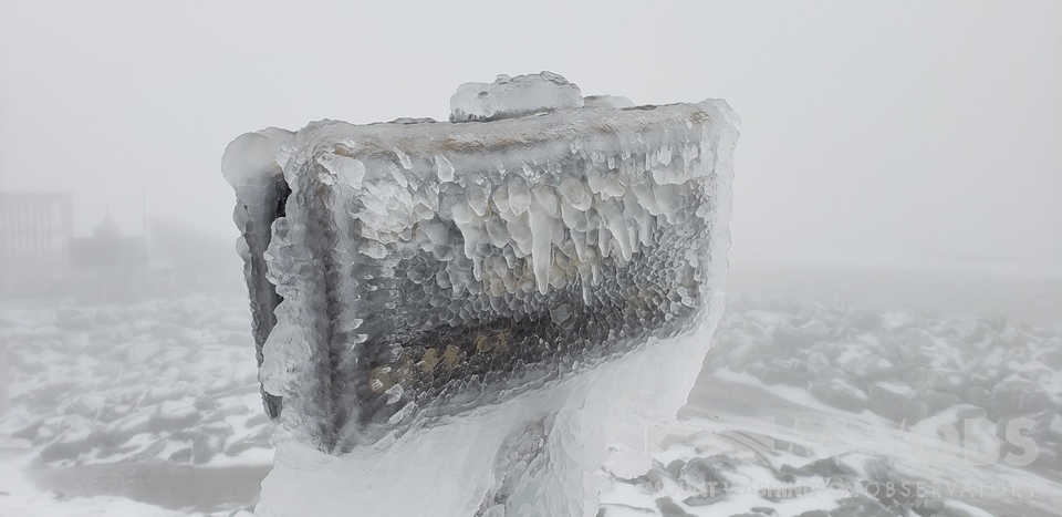
It is always really cool to see the summit coated in glaze ice. I am used to rime ice which is opaque and makes for a very wintery look. Everything coated in glaze ice is shiny and kind of looks like a glazed donut outside. Which luckily our volunteers have made plenty of treats because it made me hungry for donuts every time I went out for the observation, especially when we had peaks of sun that made the ice glisten.
The next unusual thing that happened this weekend was after we cleared from the clouds on Monday. The air above the cloud deck was very warm so after clearing from the clouds and a complete undercast formed, the temperatures shot up, well above what was forecasted. The daytime highs were expected to be in the upper 30’s being at the top of the cloud layer but the high was a little stronger than forecasted. The sinking air associated with the high pressure pushed the top of the clouds below summit level. Here is the sounding from Monday afternoon, also from Gray Maine, showing that distinct warm layer starting at about 5000 feet. This means that we were having the nice weather and the valleys were seeing clouds and drizzle.

Adam Gill, Weather Observer/IT Specialist
What the Rockpile Taught Me (Besides How to Dress for the Arctic)
What the Rockpile Taught Me (Besides How to Dress for the Arctic) By Kathryn Hawkes It turns out that living on the top of a mountain will teach you A LOT of things. How
Hiker Safety
Hiker Safety By Fawn Langerman, Dave Fatula and Julie Saccardo USFS Trailhead Steward volunteering season has begun, and hiker safety is on my mind. Truthfully, hiker safety is always on my mind, but more

Watch Our 2026 Annual Meeting and Read About the Highlights
Watch Our 2026 Annual Meeting and Read About the Highlights By Drew Bush United States Representative Maggie Goodlander headlined Mount Washington Observatory’s 2026 Annual Meeting, and she set the tone right from the start.
