
Winter is Back!
2014-05-05 18:35:26.000 – Samuel Hewitt, Summit Intern

NULL
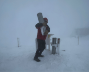
Even though the calendar reads May, it has felt more like February on the summit over the last 3 days. A slow moving upper-level disturbance has resulted in wave after wave of precipitation across New England. On the summit, afternoon high temperatures around 30 degrees Fahrenheit have allowed the precipitation to fall as a mix of snow, snow pellets and ice pellets. Yesterday, we recorded 8.1″ of new snow, the most snow the summit has seen in a single day since March 20th. Although it is only May 5th, the summit has seen 12.6″ of snow so far this month (as of 1:30 EDT today), which is 0.4″ above normal. This is the most snow recorded during the month of May since 2006.
Looking ahead to the next few days, high pressure will begin to build tomorrow, likely clearing the summits of fog during the overnight hours and keeping mostly clear conditions in the forecast through at least Thursday. The next chance for significant precipitation appears to be sometime early this weekend and temperatures at this time look to be above freezing, which would allow for plain rain to fall.
Samuel Hewitt, Summit Intern

From the Sunshine State to the Home of the World’s Weather
From the Sunshine State to the Home of the World's Weather By Kristen Mihalcik Hello Everyone! My name is Kristen Mihalcik, and I’m one of the Summer interns here at Mount Washington. Enjoying
The Precip Can: Measuring Rain, Snow, and Everything Else on Mount Washington
The Precip Can: Measuring Rain, Snow, and Everything Else on Mount Washington By MWOBS Staff Averaging 281 inches of snow per year, the Observatory is no stranger to measuring precipitation. While it might be
Meet MWOBS’ 2026 Seek the Peak Teams
Meet MWOBS’ 2026 Seek the Peak Teams By MWOBS Staff Another year, another epic Seek the Peak! As of June 2026, there are 430 hikers signed up for Mount Washington Observatory's annual summer fundraiser and
