
Snowy end to 2013
2013-12-28 18:25:38.000 – Tom Padham, Weather Observer/Meteorologist
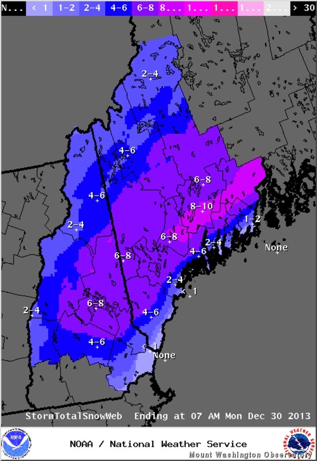
Projected storm snowfall totals from NWS
A snowy December is now just about in the books, with one last hurrah as a quick moving coastal storm moves through Sunday night. As of Saturday afternoon, the summit has picked up 52.1 in of snowfall, which is about 6 in over our monthly average of 45.5 in. With current projected snowfall totals from the next storm looking to be roughly 6 inches, we could end up being over a foot above average for December snowfall!
As far as the storm goes for the surrounding valleys, snow will begin from this system by the late afternoon, and possibly mix with or even change to rain briefly as temperatures start off slightly above freezing. Any mixing will change over to all snow in the evening as colder air works into the area. Snow will fall heavily at times overnight, but due to the very quick movement of the storm most of the snow will be over by the pre-dawn hours Monday. 6-10 inches of snow will be possible by tomorrow morning, with the highest amounts of snow from the storm over parts of central and eastern Maine just inland from the coast, where over a foot of snow cold fall.
Tom Padham, Weather Observer/Meteorologist

Mountains and Meteorology: What More Could a Girl Need?
Mountains and Meteorology: What More Could a Girl Need? By Emily Grainger Hi everyone! My name is Emily Grainger, and I am one of this fall’s Summit Interns atop Mount Washington! I’m from Orlando,

My Fear of Weather Became a Love of Meteorology
My Fear of Weather Became a Love of Meteorology By Kaitlin Farrell Hello! My name is Kaitlin Farrell. I am one of the fall summit interns here at Mount Washington Observatory. I recently graduated

Ascending with High Winds
Ascending with High Winds By Alonso Lopez Hi! I am Alonso Lopez, one of four interns at Mount Washington Observatory from August to December, 2026. I was born and raised in the Dallas-Fort Worth