
NULL
2011-01-16 22:23:27.000 – Mike Carmon, Staff Meteorologist
The next contestant
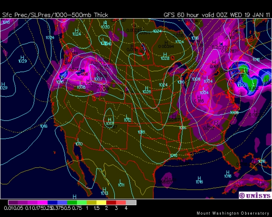
Nor’easter number three is coming!
I can’t guarantee this of course (allow me to use the often circuitous reasoning of a meteorologist for a few moments when I say computer models are by no means perfect, and we can’t put any warranty on forecasts longer than 2-3 days, etc., etc., etc.). However, the scenario has been shaping up nicely for the past couple of days, and it’s looking more and more like a significant event.
The catch is the odd approach this system will take in making its presence known across New England. What looks to be a strong southerly flow will usher in some unusually warm air near the surface, which will give the valleys below a mess of wintry precipitation in the form of snow, sleet, and freezing rain on Tuesday night and Wednesday as temperatures creep into the mid 30s.
Up here on the good ol’ rockpile, our temperatures on Tuesday and Wednesday look to make it up into the sweltering (by January standards) mid 20s, which means our requisite snow could very well become a wintry mix at times as well. The unfortunate part about this storm is the timing–Wednesday, Wednesday, Wednesday. It forever seems that wintertime storms tend to gravitate towards shift change days like moths to flame. I cite last Wednesday’s Nor’easter as the latest example in a long line of storms that serve as sufficient evidence of this theory. Not only does this present an obstacle for getting up and down the Auto Road, but three out of four of us that will be heading down on Wednesday have a 3-ish hour drive home. As one can imagine, these wintry commuting days can get old in a hurry.
As always, the caveat lies in the uncertainty and extreme sensitivity of the precipitation amount/type(s) to the exact tracks of these coastal lows. With a tiny wobble either way, a wholly different sequence of events could unfold. So as tomorrow progresses and the models become increasingly (un)confident in their predictions and consistent with each other, I hope to nail down what will most likely prove to be quite a tricky forecast!
Mike Carmon, Staff Meteorologist
Home on the Range
Home on the Range By Athena Hendrick Nice to meet you! My name is Athena, and I’ve just begun my climate science communication internship with the Mount Washington Observatory, Appalachian Mountain Club, and Hubbard
Seek the Peak Spotlight: Sandy and Joan Kurtz
Seek the Peak Spotlight: Sandy and Joan Kurtz By MWOBS Staff Sandy and Joan Kurtz have been active supporters of Mount Washington Observatory for almost five decades. After visiting North Conway in 1980, they
Living the Night Life
Living the Night Life By Madelynn Smith My alarm goes off in the bunkroom, with blackout curtains obscuring the sun’s rays as it begins to lower in the sky. My day starts in the
