
My Auto Road Hike
2008-03-18 18:09:14.000 – Matthew Morin, Space Grant Intern

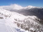
The Auto Road at 4300 feet
A lot of people envision the concept of research as sitting in front of a computer for hours feverishly analyzing huge amounts of data. This is a pretty accurate summation of my research project* for the most part. However, there are a few occasions where my research takes on a whole new direction.
I was given the task of cataloging the microclimatology of the seven Auto Road Vertical Temperature Profile (ARVTP) sites. Having detailed site descriptions will give researchers a better understanding of the factors that affect the temperatures that are automatically and remotely recorded every minute at each location of the ARVTP. To accomplish this task, I decided that I needed to hike to each site and document its temperature-affecting factors such as amount of solar exposure, snow pack issues, and nearby vegetation.
After discussing the logistics of such an operation with a few seasoned hikers, I gathered all required materials and set out for the Auto Road. After a four hour drive from Central Massachusetts, I arrived at the base of the Auto Road (elevation 1600’) at 6:00 am. The winds at the base were calm and the temperature was around 16°F. The forecast for the summit looked just about perfect for a winter hike. My only concern was the wind chill advisory in effect for that day. It was expected that wind chills would be 25-35 below in the morning and then rise to 20-30 below that evening. According to the NOAA’s National Weather Service Windchill Chart, today’s wind chills have the ability to cause frostbite to exposed skin in about ten minutes. Knowing this, I packed extra warm clothing and wore more layers than I usually do on a winter hike.
So, with the first hint of daylight I began my hike up the Auto Road. By 5:45 am I reached my first target, the 2300’ site. I was amazed by what I saw. The temperature and humidity sensors, normally at a standard height of two meters above the surface, were just about buried by this winter’s abundant snowfall. This would be considered a “snow pack issue”. By decreasing the normal distance between the surface and the sensors, proper temperature and humidity measurement could be impaired due to a larger influence from the snow pack rather than the ambient air. Future considerations will go into the idea of digging out these sites when the nearby snow pack becomes too high.
In addition to my site descriptions, I also wanted to verify the temperature and humidity values being recorded at each location. To do this, I brought along a calibrated sling psychrometer that I used to measure the dry and wet bulb temperatures. From these values I will be able to get the air temperature and, with lots of calculations, the relative humidity. Back at my computer, I would then compare my observed temperature and relative humidity numbers with what was recorded in the ARVTP database.
I repeated the site description and verification procedures for the rest of the ARVTP locations. It was a great hike even though winds steadily increased with height and blowing snow made snow drifts that were a bit difficult to walk through. All in all, it was definitely worth my efforts because I captured many photos of amazing vistas and I completed an essential part of my research on the Auto Road vertical temperature profile.
*For a brief background on the Mount Washington Auto Road Vertical Temperature Profile (ARVTP), visit http://www.mountwashington.org/weather/arvtp/.
Matthew Morin, Space Grant Intern
Hiker Safety
Hiker Safety By Fawn Langerman, Dave Fatula and Julie Saccardo USFS Trailhead Steward volunteering season has begun, and hiker safety is on my mind. Truthfully, hiker safety is always on my mind, but more
Watch Our 2026 Annual Meeting and Read About the Highlights
Watch Our 2026 Annual Meeting and Read About the Highlights By Drew Bush United States Representative Maggie Goodlander headlined Mount Washington Observatory’s 2026 Annual Meeting, and she set the tone right from the start.
Seek the Peak Spotlight: The Middleton Family
Seek the Peak Spotlight: The Middleton Family By MWOBS Staff Every summer, the White Mountains offer no shortage of reasons to get outside. Trails stretch in every direction—endless miles of terrain, summits that each
