
A Closer Look at New Hampshire’s First Ground-Based Scanning Technology
By Ellen Estabrook
On a brisk but sunny morning in early January 2026, a large black box sat in an undisclosed area of Bretton Woods as team members from Mount Washington Observatory, Omni Mount Washington Resort, and Vaisala—a global leader in environmental measurement technology—gathered with anticipation to install a cutting edge, ground-based light detection and ranging unit (LiDAR).
A forklift and a few hours later, the Vaisala WindCube 200S was on and in the beginning stages of programming, marking an exciting era of high-resolution wind and boundary layer analysis across complex terrain— specifically, Mount Washington and its nearby higher summits of New Hampshire’s White Mountains.
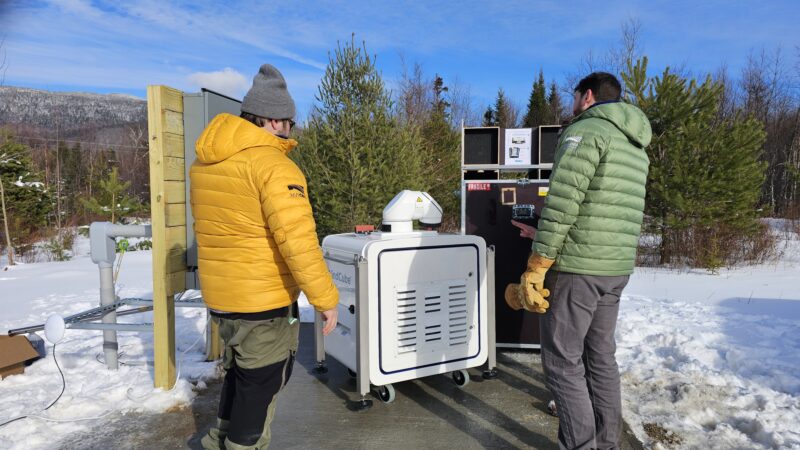
Director of Technology Keith Garrett (left) and Director of Weather Operations Jay Broccolo during the WindCube installation at Bretton Woods.
Mount Washington Observatory’s first foray with this technology began some twenty years ago with two collaborative projects. The Mount Washington Icing Sensor Project (MWISP) and GroundWinds partnerships evaluated remote sensing technologies, temporarily ground-truthing for satellite data. Looking back on these projects today offers a full circle moment for MWOBS Director of Weather Operations Jay Broccolo and the Observatory’s research and technology teams, who now have a long-term lens into atmospheric data.
“The scanner will allow us to essentially send a laser beam upward through the lower atmosphere, often several kilometers up in favorable conditions, so that we can build a three-dimensional picture of how winds move through and over the mountains, something we have not previously been able to capture with continuous, high-resolution observations,” Broccolo explained.
“This has been a long time dream in the making,” Broccolo shared. “It’s exciting to have made it to this point.”
Adding to the comprehensive data collected by the Observatory’s summit station and Mountain Washington Regional Mesonet (a network of automated stations continuously collecting weather data) the scanning Doppler LiDAR will enable reliable monitoring of atmospheric parameters such as wind, turbulence, clouds, and aerosols from a unit situated at ~1,600 feet in elevation, offering a “full wind picture” with comprehensive wind maps and data.
The Science Behind the Scanning Technology
The Windcube’s doppler imaging plays a critical role across industries including wind power, aviation, and air quality and risk, among others. For weather and climate monitoring, it not only unlocks continuous wind data, but also hyperlocal atmospheric insights and climate modeling with long- range, 360-degree, 3-dimensional awareness.
“This doppler scanner is monumental for our wind, cloud, and general lower-atmosphere studies, especially regarding the boundary layer, which heavily influences Mount Washington’s uniquely extreme weather,” shared Broccolo.
The boundary layer (PBL, Planetary Boundary Layer), also referred to as the Atmospheric Boundary Layer (ABL), is the lowest part of the atmosphere, directly influenced by the Earth’s surface, where winds, temperature, and turbulence respond to surface heating, cooling, friction, and terrain on timescales of minutes to hours.
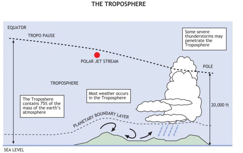
Graphic: https://skybrary.aero/articles/planetary-boundary-layer
The scanning LiDAR unit collects boundary layer data by emitting short pulses of infrared laser light into the atmosphere, hitting aerosol particles in the air. The light then reflects back to the sensor, measuring the frequency change in the returned light (the Doppler shift). A programmable rotating head creates 3D, spherical, or vertical scans with modes including:
• PPI (Plan Position Indicator)– Provides a wide horizontal “slice” or map of wind speed and direction for identifying horizontal wind variations across a large area.
• RHI (Range Height Indicator)- Generates a vertical cross-section of the atmosphere for studying the vertical structure of the boundary layer or analyzing wind flow over complex terrain.
• DBS (Doppler Beam Swinging)- Reconstructs a vertical wind profile directly above the unit, providing standard meteorological data on wind speed, direction, and turbulence at multiple heights up to 12 km.
• LOS (Line of Sight)- Measures radial wind speed continuously along a single specific path for targeting specific features, such as the wake behind a single turbine or a narrow mountain pass. (Vaisala, 2024)
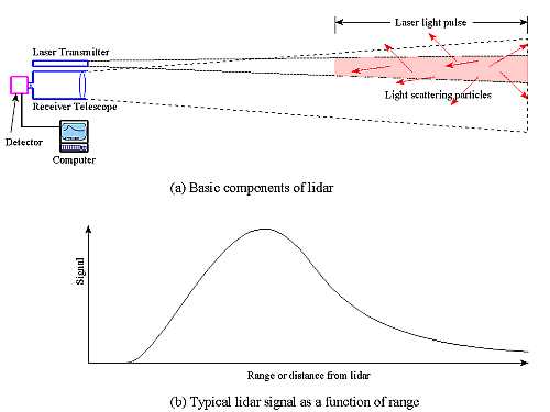
Basic components of LiDAR. Graphic by NOAA.
For a closer look at the WindCube’s capabilities in action, visit Vaisala’s video linked here.
Implications for Research
The benefits of this data are far-reaching, from enhanced forecasts and safety for visitors, to scientific advancements to better understand one of the most unique environments on Earth. For example, the WindCube will make it possible for the Observatory and its research partners to study how the height of the boundary layer changes with different weather patterns, and what the wind field looks like before it interacts with the Presidential Range terrain.
“This information has direct operational and research value,” Broccolo said. “Improved understanding of wind structure and boundary layer height can enhance forecasting for high-elevation weather, support recreation safety, and contribute to national mesonet data streams. It also positions the Observatory to contribute more meaningfully to broader discussions about mountain meteorology and boundary layer dynamics.”
The installation contributes to the Observatory’s role as a world-class destination for research and increases accessibility of data for researchers and the public, as the team prepares to share the real-time data and insights on mountwashington.org.
The project is made possible by a Congressionally Directed Spending request by U.S. Senator Jeanne Shaheen, with generous installation support by Bretton Woods Ski Area/Omni Mount Washington Resort.
Resource: Vaisala. (2024). WindCube Scan: Long-range scanning LiDAR for wind energy and meteorology [Product brochure]. vaisala.com
Additional Resources
https://www.vaisala.com/en/products/windcube-scan-meteorology
https://www.vaisala.com/sites/default/files/documents/WEA-ERG-eBook-ScanningLidar-B212128EN-public.pdf
https://docs.vaisala.com/api/khub/documents/V4Ktyr0Yr8oCiZtXtLm49A/content
https://csl.noaa.gov/groups/csl3/instruments/dial/lidar.html
https://skybrary.aero/articles/planetary-boundary-layer
From One Mountain to the Next
From One Mountain to the Next By Ellie Derry Hi everyone! My name is Ellie Derry and I am one of the fall 2026 interns at the Observatory. I’m super excited to be here
Mountains and Meteorology: What More Could a Girl Need?
Mountains and Meteorology: What More Could a Girl Need? By Emily Grainger Hi everyone! My name is Emily Grainger, and I am one of this fall’s Summit Interns atop Mount Washington! I’m from Orlando,
My Fear of Weather Became a Love of Meteorology
My Fear of Weather Became a Love of Meteorology By Kaitlin Farrell Hello! My name is Kaitlin Farrell. I am one of the fall summit interns here at Mount Washington Observatory. I recently graduated