
A New Daily Record Low
2012-04-29 16:49:20.000 – Brian Clark, Weather Observer/Education Specialist

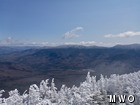
Distinct freezing line on the Carter-Moriah Range
It’s been an interesting month and a half for me. After being away from the summit for 25 days while on vacation, my first week back was spent working the overnight shift to cover for Ryan while he took his turn on vacation. Of course, I typically work during the day, and the one time every year that I work nights is the week Ryan takes vacation. Then, for this current shift, I spent half of it working down at our Weather Discovery Center, beginning to catch up on some much needed work in the studio that is located there, and is used for our Distance Learning program. I came up on Saturday morning to the summit to finish off this shift, with Ken giving me a ride up in the Observatory truck. As the last couple of comments have indicated, some wintry weather has returned this week (not unusual for this time of year) and made the use of chains on the tires of the truck a necessity on our way up yesterday.
Although temperatures were at their lowest yesterday with a low of 4 degrees, today’s low of 7 degree F set a new daily record low for April 29. The previous record was 8 degrees, which was set in 1947. Interestingly enough, this is the first time a record low has been broken since December 8, 2008, when a temperature of -25 degrees F was measured. There was one other instance between now and then when a record low was equaled, but even that was a while ago, occurring on August 8, 2009.
This round of winter weather is about to come to end though. Cold, Canadian high pressure that has been building into the region will slowly shift eastward tomorrow, and as the center of the high moves over us an we move to the west side of the high, warmer air will be brought up from the south. In this case, ‘warmer’ simply means more seasonable, with average daily temperatures in the upper 20’s!
Brian Clark, Weather Observer/Education Specialist

Seek the Peak Spotlight: The Cloud Chasers
Seek the Peak Spotlight: The Cloud Chasers By MWOBS Staff Mike Bergeron and Desiree Bolton have been participating and volunteering for Seek the Peak for three years now. Together, they comprise Team Cloud Chasers

Celebrating 250 Years: The Declaration’s Legacy in the White Mountains
Celebrating 250 Years: The Declaration's Legacy in the White Mountains By Peter Crane We are now approaching July Fourth, Independence Day, the day when we celebrate the adoption of the Declaration of Independence in

Seek the Peak Spotlight: Ryan Shepard
Seek the Peak Spotlight: Ryan Shepard By MWOBS Staff Before Ryan Shepard moved to Conway, he was in Western New York celebrating his 40th birthday party. “I wanted to go big,” he said. “Big”
