
A Winter Outlook as Ski Season Begins in New Hampshire
2021-12-22 10:18:13.000 – Stephen Durham, Weather Observer/Education Specialist
During a recent virtual reception hosted by Ski New Hampshire, I had the opportunity to present and talk with ski areas of the region about the winter we can expect in the White Mountains. With over a dozen ski areas across New Hampshire, knowing what could be ahead for our winter in terms of snow and cold is important as ever for their industry.
What We’ve Seen:
October was an above average month in terms of temperatures across the region, including the summit of Mount Washington, and multiple lower-elevation weather reporting stations. Once we got into November though, winter seemed underway at the summit at least with temperatures getting below average for the majority of the first week thanks to a middle level trough over the region.
After this cold period, we saw a moderation in temperatures, where they warmed to near or just above average. We saw this type of fluctuation through the entire month at the summit with short periods of warm-ups, followed by colder periods.
|
Average Temp |
Avg Max Temp |
Avg Minimum Temp |
|
|
KMWN(summit) Nov 21’ (Departure) |
24.8°F (-3.6°F) |
12.1°F (-1.0°F) |
18.4°F (-2.4°F) |
|
1990-2020 Nov Average |
28.4°F |
13.1°F |
20.8°F |
|
NCON3(North Conway) Nov 21’ |
48.6°F (+2.4°F) |
27.4°F (+0.1°F) |
38.0°F (+1.2°F) |
|
1990-2020 Average |
46.2°F |
27.3°F |
36.8°F |
Table 1: Mount Washington and North Conway Weather Stations for November 2021 and month’s average from 1990 to 2020
With the increased fluctuations of the jet stream due to these changing temperatures, there was increased storminess, but we saw the departure for precipitation to be below average, while recording above average snowfall. This can be correlated to the summit seeing below average temperatures, and seeing higher ratios of snowfall (drier snow) during the periods when we had weak storms. For lower elevations, such as North Conway (NCON3), below average snowfall for November included only a trace.
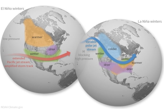
The flow of the jet stream over this period was very quick, with an active polar jet stream into the United States. The active polar jet stream can be related to the ENSO conditions being monitored in the Pacific Ocean with the occurrence of La Niña. With the jet stream being active and fluctuating, this allowed for a typical weather pattern where we saw periods of colder temperatures and at times warmer temperatures. We can compare this to the image below on La Niña winters, which shows periods of colder temperatures coming in from Canada, and warmer air moving in from the south when the jet stream is varying.
What Can Be Expected:
December started off temperatures at both the summit and North Conway being below average. There have also been two periods of warmth for the region where temperatures were well above average and broke two daily record highs at the summit. For the month, temperatures are above average for both locations. Snowfall for the North Conway station has been above average for the month by .5 inches, but below average for the season. For the summit, snowfall is on pace at 25.1 inches as of December 21. The December average for snowfall is 47.7 inches.
As we head into the final days of December, I see the potential for another brief above-average period for temperatures. The trend to the start of winter has entailed fluctuations and a battle between what we observe in temperatures. In comparison to La Niña, we continue to see an active polar jet stream. This brings periods of colder and below average temperatures compared to our 1990-2020 climate period. In the coming months, we can also expect the other side of the token where we see brief stretches of warm-ups across the region.
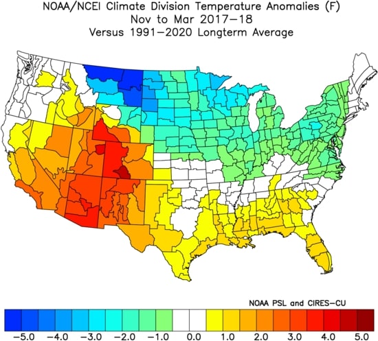
As I mentioned in my presentation to Ski New Hampshire, a year to which we can draw a comparison is the winter of 2017-2018. The image below shows the temperature anomalies for the United States from November 2017 to March 2018. That winter was a second La Niña Winter, similar to this winter where we have a second year La Niña. That winter, we saw near to just-below average temperatures and just around average precipitation. It’s always important to keep in mind that there are other influences on the weather pattern that dictate which direction our winter will go.
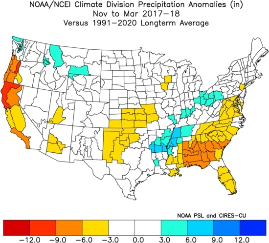
Looking at the precipitation for that winter, we saw right around average for the periods from November until March of 2018. This can be seen in the figure below for the anomaly of precipitation for November of 2017 to March of 2018 in comparison to the 1991-2020 climate range.
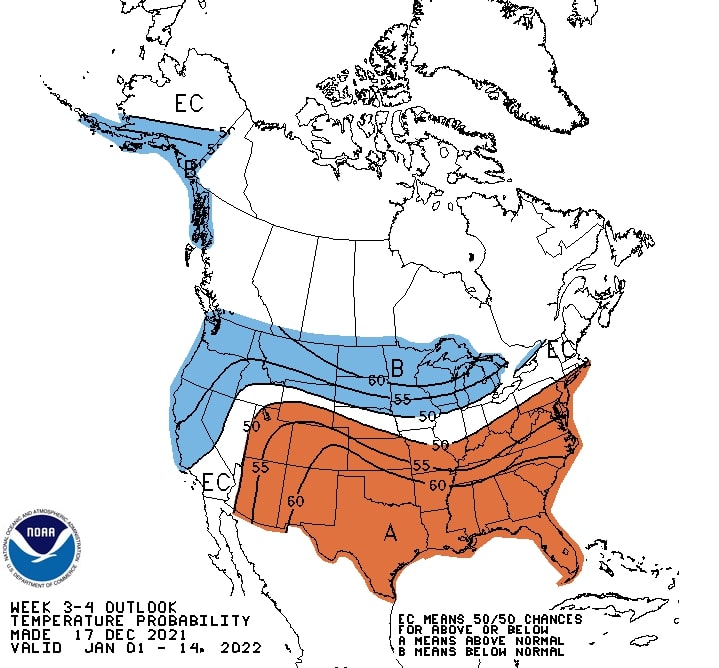
In the end, my belief in what can be expected is, we will likely see a transient and fluctuating weather pattern in the coming weeks. There is potential in the right circumstances we see a period of storminess, where we see more snow over a period, compared to other weeks, but we could also be on the other side of temperature equation with warmer periods as well. I see the chances for overrunning events, where we see warm air moving in over colder air or cold air damming events. This is when we see storms start off as snow, changing to a wintry mix of sleet or freezing rain, to eventually plain rain. This prediction can be related to NOAA’s Climate Prediction Center outlook for the next 3-4 weeks where we have equal chances of seeing either above or below average temperatures as we head into January.
Stephen Durham, Weather Observer/Education Specialist

Seek the Peak Spotlight: The Cloud Chasers
Seek the Peak Spotlight: The Cloud Chasers By MWOBS Staff Mike Bergeron and Desiree Bolton have been participating and volunteering for Seek the Peak for three years now. Together, they comprise Team Cloud Chasers

Celebrating 250 Years: The Declaration’s Legacy in the White Mountains
Celebrating 250 Years: The Declaration's Legacy in the White Mountains By Peter Crane We are now approaching July Fourth, Independence Day, the day when we celebrate the adoption of the Declaration of Independence in

Seek the Peak Spotlight: Ryan Shepard
Seek the Peak Spotlight: Ryan Shepard By MWOBS Staff Before Ryan Shepard moved to Conway, he was in Western New York celebrating his 40th birthday party. “I wanted to go big,” he said. “Big”
