
All I Want For Christmas is…More Snow!
2020-12-21 14:55:30.000 – Sam Robinson, Weather Observer/Engineer
Today is the winter solstice so I figured it would be a good day to write about snow. At the time of writing, the forecast for Christmas Eve through Christmas day looks pretty dreary. The chances of receiving the winter weather equivalent of “coal” this year seems increasing likely: heavy rain and warmth. This late fall/early winter so far has been very New England-like with bouts of snow and cold, followed by rain and warming. Up here on the summit, we have seen slightly above average snowfall for October, followed by below average snowfall for November, and with December so far being right around average if we continue at the current rate. Unfortunately, the forecast for the next week does not promise much in the way of snow, so we will need a late storm to boost us up to average. Although the low snow across the north is a disappointment to snow lovers like myself, it is also an inconvenience to ski resorts who are forced to make snow, as well as for us planning our weekly summit shift changes. By this time in a normal winter season, the snow cat would be the main and only form of transportation top to bottom. Lately we have had to decide between van and truck with chains, a combination of wheeled vehicle and snow cat, or simply just the cat. The lack of significant snow pack has also allowed the snow cat ride, which takes upwards of multiple hours normally, to take just over an hour because of the minimal amount of plowing we have to do to keep the road passable.
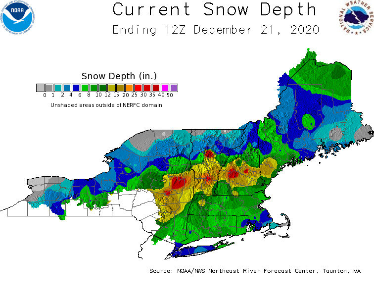
In my home state of Massachusetts we received about a foot statewide from that storm, with some northwestern areas receiving about 2 feet. Unbelievably, NWS Boston says we have already received more snow statewide than we did the entire winter season of 2019! Needless to say, the southern half of New England is starting off winter on a snowy foot, while the northern half has some catching up to do. The overall pattern looks to remain relatively active, and cold air is close by so hopefully more snow is on the horizon. Fingers crossed this upcoming rain storm does not do too much damage to the existing snowpack and we can resume with our normal winter weather. After all, winter is just starting.
Have a safe and happy holidays, and remember to think snow!
Sam Robinson, Weather Observer/Engineer

Seek the Peak Spotlight: The Cloud Chasers
Seek the Peak Spotlight: The Cloud Chasers By MWOBS Staff Mike Bergeron and Desiree Bolton have been participating and volunteering for Seek the Peak for three years now. Together, they comprise Team Cloud Chasers

Celebrating 250 Years: The Declaration’s Legacy in the White Mountains
Celebrating 250 Years: The Declaration's Legacy in the White Mountains By Peter Crane We are now approaching July Fourth, Independence Day, the day when we celebrate the adoption of the Declaration of Independence in

Seek the Peak Spotlight: Ryan Shepard
Seek the Peak Spotlight: Ryan Shepard By MWOBS Staff Before Ryan Shepard moved to Conway, he was in Western New York celebrating his 40th birthday party. “I wanted to go big,” he said. “Big”
