Analyzing Daily Maximum and Minimum Temperatures
2015-08-30 17:05:06.000 – Mike Dorfman, Weather Observer/IT Specialist
I love data. I’m currently pushing through and organizing all of our remote site data (millions of data points) as we move to a new system. Hopefully this system will allow for higher reliability as well as more sophisticated tools for weather display and data manipulation for our weather data. While sifting through our weather data I enjoyed watching the cycles of temperature and wind speed associated with the New England seasons as well as the diurnal temperature cycle that happens every day and night.
I decided to do a quick analysis of daily highs and lows for the summit and our Bartlett Research Facility mesonet site. I was interested in seeing how much daytime heating influences temperatures at these two locations compared to large-scale synoptic patterns. To do this, I first found the daily highs and lows with a few MySQL database queries. I sorted each daily high and each daily low into a “bin” that contained all the other data points from within that hour of the day. Once all the data points were sorted into their appropriate bins, I used excel to determine what percentage of data points were in each of the bins. The summit data consisted of over 3300 data points and the Bartlett data contained over 1300 data points.
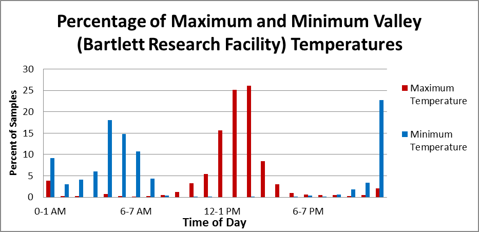
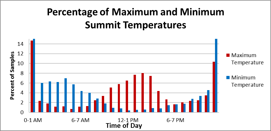
Below is a bar graph indicating what time the high and low temperatures occur for both the summit and the Bartlett Research Facility in the valley. The top graph is the Bartlett Research Facility, and the bottom graph is the summit of Mount Washington. It is immediately evident that more than 65 percent of the daily highs in the valley fall between noon and 3 PM. In contrast, while the summits generally see their high temperatures mid-afternoon and low temperatures overnight, the Rockpile has a much wider spread of when the daily highs and lows can occur. This is likely due to elevation; the summit is much further away from the valley where daytime heating has more of an influence. In addition, we are sticking up where air is more well-mixed than in the valley. Overall, synoptic-scale patterns have more of an influence on when the summit reaches its highs and lows when compared with the valley.


One thing that immediately drew my attention is the likelihood of daily highs and lows being hit at midnight. This occurs if temperatures are falling or rising throughout the day with synoptic scale patterns trumping any cooling or heating from the sun. If a colder air mass is moving into a region, temperature will gradually cool throughout the day, and if a warm air mass pushes over the region, the area will gradually warm. This cooling and warming action can have more of an influence than daytime heating.
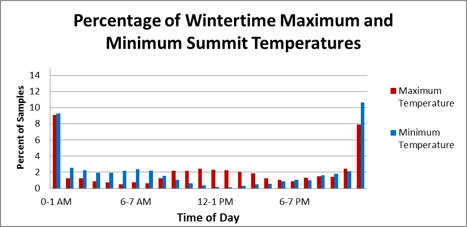
The graphs below are the same as above, except discerning between summertime and wintertime highs and lows. In the wintertime, daytime heating has much less of an effect on temperature. This is one of the main reasons why we don’t receive as many thunderstorms in the wintertime; there just isn’t enough solar gain to create intense convection. This is especially evident in the summit graph, where there is less than a 1 % difference between the getting a high temperature in the middle of the day vs. the middle of the night.
This effect is much less evident with the Bartlett site-we see a small increase in the spread of the highs and lows in the wintertime, however this does not seem to be significant. This is understandable, as Bartlett is in a much more protected area, and solar radiation will more likely have more of an effect on the air cushioning the ground.


Our Director of Research, Dr. Eric Kelsey, is performing ongoing research of the boundary layer in the White Mountains, and these graphs are indirectly referencing this. The boundary layer is the layer of air closest to the earth that is influenced by the surface. It is much thicker in the summertime when there is much more convection pushing up to (and often above) the summit, and it is much thinner in the wintertime, when solar gain on the ground is minimal.
These graphs also tell a story of comfort. If you’re on a chilly alpine start heading to the summit, don’t assume that temperatures will necessarily warm up as the day progresses. Especially in the wintertime, the higher summits are generally much more influenced by synoptic patterns than daytime heating. Whether summertime or wintertime, it’s important to check our
higher summits forecast before heading out for a hike!
Mike Dorfman, Weather Observer/IT Specialist


