
Another Record Low Coming?
2017-03-21 12:59:12.000 – Nathan Flinchbaugh, Summit Intern
If you’ve been in the Northeast this month, you don’t need a meteorologist to tell you it’s been cold. It almost seems as if February and March have traded their weather to one another. The summit of Mount Washington has been no exception. Even though March is still very much a wintry time, with 45 inches of snow falling on average, the summit staff is continuing to keep tabs on a March not seen for a long time.
Despite the fact that we still have over a week to go in the month, the statistics compiled so far for March indicate an abnormally cold start to meteorological spring. Up to this point, the summit has recorded 6 days this month in which the mercury did not top zero. Back on the 11th, the summit dipped to 35 degrees below zero, shattering the previous record of -26 set all the way back in 1933, the second year of the Observatory’s existence. Tallying all of the days up thus far, March has been almost 10 whole degrees below average. And now, it looks like we may draw close to yet another record low Wednesday and/or Thursday. Both record lows for these two dates, -25 and -26 respectively, have stood since 1934, only the third year the Observatory was operational.
As of Tuesday morning, the cold air waiting in the wings was centered under an area of high pressure over the Canadian Plains.
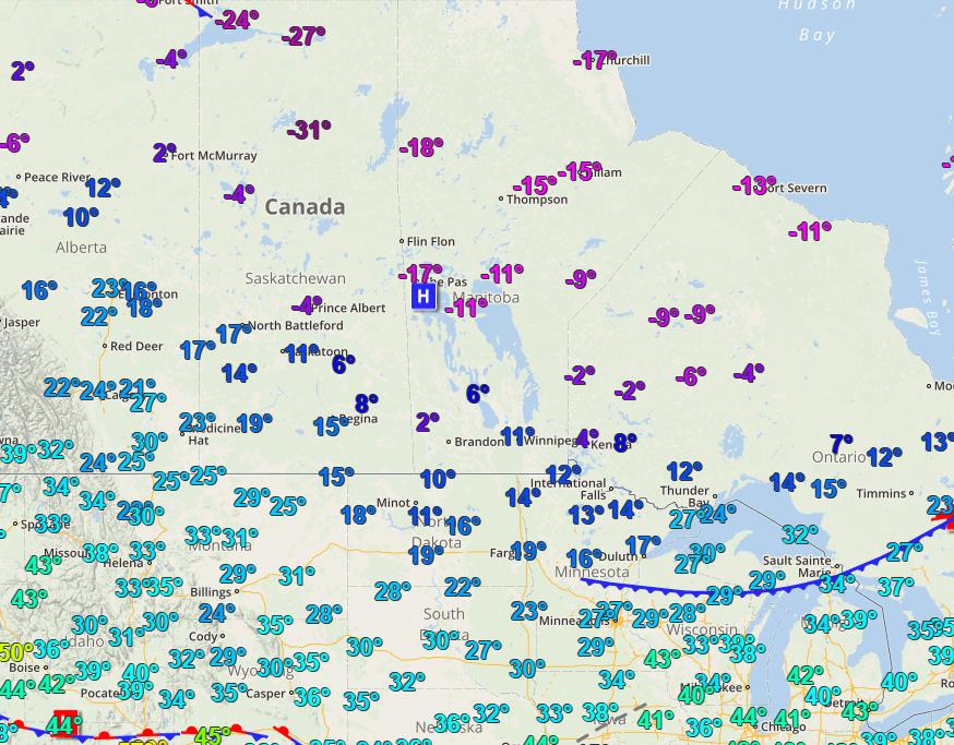
Temperatures over Central Canada as of 10am EDT Tuesday.
A cold front will pass through the region Tuesday, followed by a more potent Arctic front Tuesday night. This will allow the extremely cold air currently locked in Canada to spill southeastward as the high drifts towards us during the day Wednesday. This will result in a temperature freefall for mid-week, with temperatures bottoming out sometime early Thursday morning.
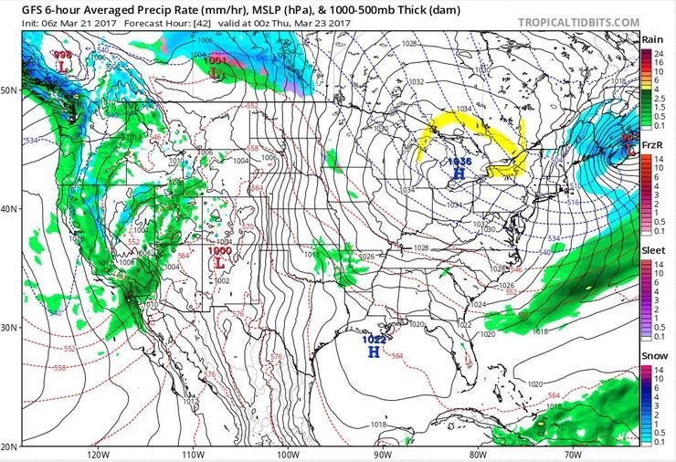
Wednesday evening, according to the GFS model. The yellow arrow indicates the clockwise rotation of high pressure, sending extremely cold air from Canada into New England Wednesday night.
The bottoming out of our temperature is what the staff will be watching. Will there be enough cold air to filter in to bring another record low to Mount Washington?
In addition to the extreme cold, with high pressure building in rapidly behind the departing arctic front, the pressure gradient will steepen, elevating our winds over hurricane force just in time for the cold to arrive. Therefore, Wind Chill Warnings have been posted for the higher peaks from Wednesday morning, through the first half of Thursday. Even though the calendar says spring, it’s still the dead of winter on Mount Washington, at least this week. As always, be sure to check our higher summits forecast page, and be prepared for anything if you plan on venturing into the White Mountains.
Nathan Flinchbaugh, Summit Intern

Seek the Peak Spotlight: The Cloud Chasers
Seek the Peak Spotlight: The Cloud Chasers By MWOBS Staff Mike Bergeron and Desiree Bolton have been participating and volunteering for Seek the Peak for three years now. Together, they comprise Team Cloud Chasers

Celebrating 250 Years: The Declaration’s Legacy in the White Mountains
Celebrating 250 Years: The Declaration's Legacy in the White Mountains By Peter Crane We are now approaching July Fourth, Independence Day, the day when we celebrate the adoption of the Declaration of Independence in

Seek the Peak Spotlight: Ryan Shepard
Seek the Peak Spotlight: Ryan Shepard By MWOBS Staff Before Ryan Shepard moved to Conway, he was in Western New York celebrating his 40th birthday party. “I wanted to go big,” he said. “Big”
