Anti-Jokes and Anti-Cyclones
2015-02-27 14:43:09.000 – Nate Iannuccillo, Summit Intern
So why was 6 afraid of 7?
It wasn’t. Numbers are not emotional and thus incapable of feeling fear.
(Cue the laugh track?)
Ok, enough with the anti-jokes, what the heck is an anticyclone?
As you hopefully inferred by noticing the prefix, an anticyclone is essentially the antithesis of our standard cyclone.
But what exactly does that mean?
First, let’s consider our standard mid-latitude cyclone in the northern hemisphere. These are the typical types of storm systems that have been rolling through New England with high frequency this winter. Remember that these are low pressure systems.
Cyclones feature winds converging around a low pressure center in the counter-clockwise direction. This rotation is what we call cyclonic flow. Air converging on the low creates the rising air that enables the clouds and precipitation associated with these systems.
Moving on to anticyclones in the northern hemisphere…
Anticyclones are high pressure systems that feature airflow diverging from a center of high pressure in a clockwise direction. The diverging air is accompanied by sinking air above. As the air subsides, it compresses and dries out, inhibiting clouds and precipitation. For this reason, we generally associate anticyclones with fair weather.
The image below is a nice visual representation of the difference between cyclonic and anticyclonic flow in the northern hemisphere. We can see cyclonic flow on the left, and anticyclonic flow on the right.
 Image courtesy of the State Climate Office of North Carolina
High pressure systems are infrequent in the northeast this time of year for a few reasons, but I wanted to draw attention to anticyclones specifically because of the relevance to this weekend’s weather.
A nice looking anticyclone has moved into the central US from Alberta and is expected to linger over the mid-Atlantic states for most of the weekend. We should expect to see the fair skies associated with this anticyclone throughout today, lasting up until Sunday night. Daily temperature fluctuations will increase as the absence of clouds allows for greater radiational heat exchange.
Let’s take a look at some model outputs…
The image below is the most recent run of the UKMET model looking ahead to 7pm EST tomorrow night. Looking below, we can see the high pressure center of our anticyclone sitting over the northeast US. Note how the shaded areas of precipitation stay on the fringes of the high pressure system. Conversely, a weak cyclone sits over the American southwest, and just as expected, the low pressure system is filled with precipitation and moisture.
Image courtesy of UQAM-Montreal Weather Centre
Anyway, enjoy a sunny weekend in New England thanks to your local anticyclone and tell some anti-jokes in celebration of your fair skies.
Here’s an ocean themed joke for the road:
What did the Atlantic Ocean say to the Pacific Ocean?
Nothing. Oceans can’t talk.
(More laugh track?)
Nate Iannuccillo, Summit Intern

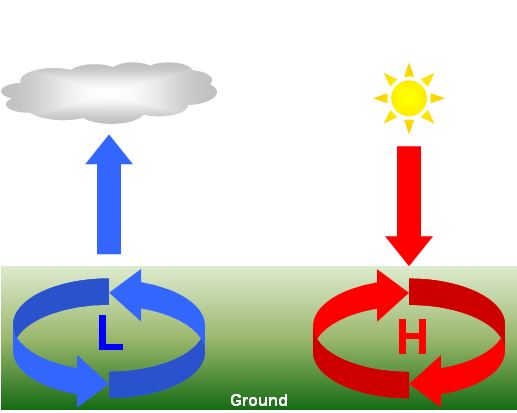 Image courtesy of the State Climate Office of North Carolina
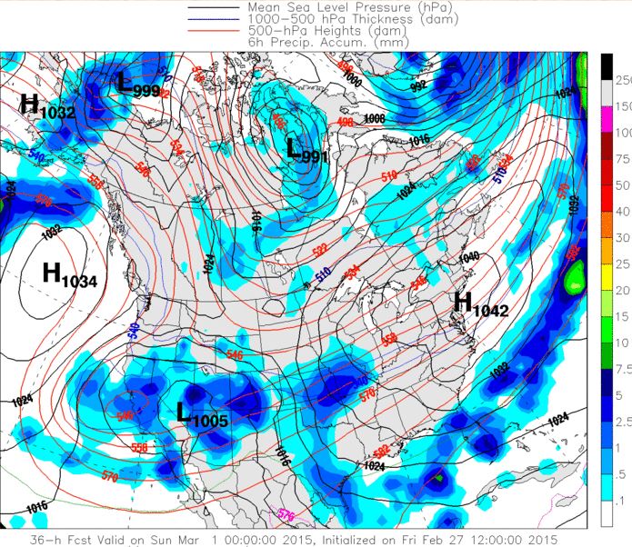 Image courtesy of UQAM-Montreal Weather Centre


