
April Fool’s Day Snow
2017-03-31 16:58:16.000 – Nathan Flinchbaugh, Summit Intern
The calendar says spring but Mother Nature doesn’t necessarily follow schedules, especially in New England. Just in time for April Fool’s Day, another snow storm stands to blanket parts of the Northeast with fresh snow. As of mid-afternoon Friday, the first bands of snow had already made it to Southern New Hampshire, with a few inches already accumulating in the southwest part of the state. Here on the Mount Washington, flakes began to fly just after noon, and fog is in the process of trying to retake the summit.
Luckily for most, this will be a rather quick hitting event, with the heaviest snow falling tonight before rapidly dissipating Saturday morning. Even so, some folks will be measuring over a foot of new snow by Saturday afternoon, including potentially staff on the summit.
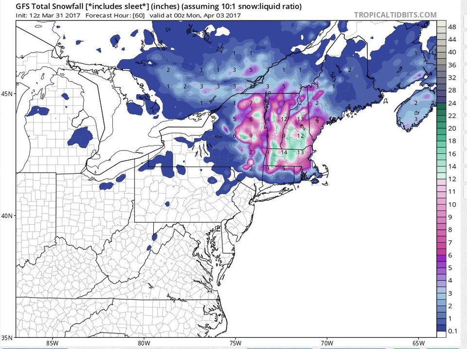
Predicted snowfall amounts for the Northeast as of Sunday evening from the GFS model.
Most models seem to indicate the jackpot region for this storm will stretch from the Merrimack Valley, southward into Worcester County, and west into the Berkshires. These are the areas that stand the best chance at receiving over a foot. The White Mountains may not pick up quite as much from this particular storm; however upslope snow showers will linger behind the departing coastal low. While most of New England is digging out Saturday afternoon, we’ll likely have an additional full day of snow showers to deal with before we dry out sometime Sunday night.
Nathan Flinchbaugh, Summit Intern
Hiker Safety
Hiker Safety By Fawn Langerman, Dave Fatula and Julie Saccardo USFS Trailhead Steward volunteering season has begun, and hiker safety is on my mind. Truthfully, hiker safety is always on my mind, but more

Watch Our 2026 Annual Meeting and Read About the Highlights
Watch Our 2026 Annual Meeting and Read About the Highlights By Drew Bush United States Representative Maggie Goodlander headlined Mount Washington Observatory’s 2026 Annual Meeting, and she set the tone right from the start.

Seek the Peak Spotlight: The Middleton Family
Seek the Peak Spotlight: The Middleton Family By MWOBS Staff Every summer, the White Mountains offer no shortage of reasons to get outside. Trails stretch in every direction—endless miles of terrain, summits that each
