Changes
2012-04-14 00:06:23.000 – Brian Clark, Weather Observer/Education Specialist
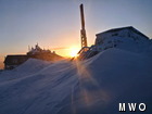
Drifting around the Tip Top House
When I left the mountain on March 17 to start my vacation, we were just heading into a long stretch of extremely unseasonable warmth. Knowing this, and the fact that the outlook for the rest of March was for continued warmth, I figured that by the time I returned on April 11, the mountain would look very different than it did when I left it. As is often the case, Mount Washington had some surprises up her proverbial sleeve.
Today was actually the first snowless day since the month of April started. So far this month we have measured nearly 33 inches of snow, with just over 22 of that coming in the last 5 days. Now, this is not terribly unusual for Mount Washington, considering that an average April sees about 42 inches of snow. However, it did make for a very different scene when I returned than what I had expected when I left.
A bunch of the snow that fell over the last few days did so while winds were relatively light. So, when winds picked up today to speeds more typical of Mount Washington, all that snow started to blow around. This has created some pretty impressive drifts around the summit, and has probably added to some of the impressive drifts we saw on our way up the road on Wednesday.
This return to winter will end this coming weekend, at least for now. Temperatures by the end of the weekend and the beginning of next week will rise into the 40’s and 50’s on the summit. It is important to keep in mind that, just like happened after the March heat wave (of sorts), things can reverse very quickly on this mountain!
Brian Clark, Weather Observer/Education Specialist
Hiker Spotlight: Sandy and Joan Kurtz
Hiker Spotlight: Sandy and Joan Kurtz Sandy and Joan Kurtz have been active supporters of Mount Washington Observatory for almost five decades. After visiting North Conway in 1980, they fell in love with the
Living the Night Life
Living the Night Life By Madelynn Smith My alarm goes off in the bunkroom, with blackout curtains obscuring the sun’s rays as it begins to lower in the sky. My day starts in the
Three and a Half Months of Snow, Ice and Rime
Three and a Half Months of Snow, Ice and Rime, with Deeper Drifts. By Ryan Steinke Me outside on the summit near the Yankee Building. My internship with the Mount Washington Observatory


