
Clear views of the snow-covered peaks…
2006-10-27 09:00:35.000 – Jim Salge, Observer

The snow-covered summit…
I honestly think that it has been an entire year since the Northern Presidential Range has looked this white. The density and depth of the early season rime has allowed it to coated everything, and has trapped a large portion of the snow on all the slopes. Given the winter that we had last year, since last October’s record snowfall, I can’t remember them this evenly coated. Perhaps the lower density snow just blows off during mid-winter, perhaps summer is clogging my memory.
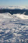
The summit has in fact cleared this morning, and an undercast leaves nearly everything within our viewscape a bright white. Finally able to survey the size of the drifts, I can tell you it’s far more than I expected. This shot shows drifts up the tip top house, while this one gives an exaggerated sense of scale. And one last photo shows the changes with elevation that the White Mountains experienced with this storm!
While we currently sit at the 3rd snowiest October on record at the Observatory, and considering the storm poised to hit the peak tomorrow, we should easily move into second despite the risk of mixing for a while. This has been quite a month!
Jim Salge, Observer

Celebrating 250 Years: The Declaration’s Legacy in the White Mountains
Celebrating 250 Years: The Declaration's Legacy in the White Mountains By Peter Crane We are now approaching July Fourth, Independence Day, the day when we celebrate the adoption of the Declaration of Independence in

Seek the Peak Spotlight: Ryan Shepard
Seek the Peak Spotlight: Ryan Shepard By MWOBS Staff Before Ryan Shepard moved to Conway, he was in Western New York celebrating his 40th birthday party. “I wanted to go big,” he said. “Big”

From Florida Heat to the Rockpile
From Florida Heat to the Rockpile By Alek Libby Hi everyone! My name is Alek Libby, and I am one of the summit interns here at Mount Washington Observatory this summer! I recently graduated
