
Downbursts! Macro and Micro
2020-05-25 16:44:56.000 – AJ Grimes, Weather Observer
To complement Ian’s latest presentation on devastating circular winds (tornados), this post will investigate a different type of damaging wind that can be present in a thunderstorm – downbursts, or straight-line winds. Downbursts are strong winds created by air falling rapidly to the ground and spreading outward from the point of contact. The winds can be damaging, with some microbursts reaching speeds of over 100 mph (about the speed of an EF1 tornado) and other downbursts reaching 150 mph or more. Though people often think about wind damage associated with tornados, downbursts are more common, and they pose a significant threat to aircraft, boats, and personal property. We have even seen downbursts here on the summit!
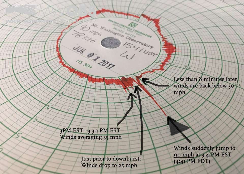
A downburst recorded on the Observatory’s Hays chart, showing the sudden spike in wind speed.
There are two main types of downbursts: microbursts and macrobursts. Microbursts are up to 2.5 miles in diameter, while macrobursts affect an area larger than 2.5 miles. There are also two main types of microbursts: wet and dry. Wet microbursts are more common in places like the Southeast and are associated with heavy precipitation in the downburst. Dry microbursts, more common in the midwestern and western United States, occur without appreciable precipitation in the downburst. The type of microburst depends on the atmospheric conditions available. When precipitation evaporates, melts, or sublimes (converts directly from ice to water vapor) within a storm cloud, it cools the air, making it denser and encouraging it to sink. Within a thunderstorm, warm updrafts rise while relatively cooler air will fall, and a large change in temperature as the air descends will cause it to fall faster. Wet microbursts are also fueled by something called precipitation loading, which occurs when downward movement of water and/or ice that had been held aloft in the updraft also drags air down quickly as it falls. There can also be hybrid microbursts, that possess features of both wet and dry microbursts. Microburst type will depend on the relative contributions of formative factors, including the pulling in of dry air, precipitation loading, cooling beneath the thunderstorm, and sublimation.
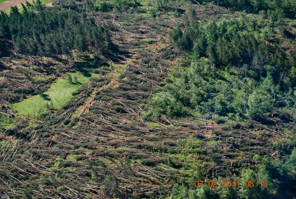
Damage from a macroburst in MN. Photo by Stacy Hopke of the Burnett County Sheriff Department, retrieved from NOAA.
The damage of straight-line wind is often mistaken for tornadic activity, though careful inspection will show damage spread out from where the air dropped, with directional airflow characteristic of straight-line (and not rotational) winds. However, small but even more powerful wind gusts within microbursts may also occur. These “burst swaths” are only 50-150 yards in length, but are capable of causing damage similar to that of a tornado.
Downbursts are another good reason to seek shelter and protect yourself when a severe thunderstorm is in your area. To learn more about different types of severe storms and precipitation, or to see Ian’s presentation focusing on tornados, head to our Virtual Classroom page at mountwashington.org/classroom and stay safe!
AJ Grimes, Weather Observer

Seek the Peak Spotlight: The Cloud Chasers
Seek the Peak Spotlight: The Cloud Chasers By MWOBS Staff Mike Bergeron and Desiree Bolton have been participating and volunteering for Seek the Peak for three years now. Together, they comprise Team Cloud Chasers

Celebrating 250 Years: The Declaration’s Legacy in the White Mountains
Celebrating 250 Years: The Declaration's Legacy in the White Mountains By Peter Crane We are now approaching July Fourth, Independence Day, the day when we celebrate the adoption of the Declaration of Independence in

Seek the Peak Spotlight: Ryan Shepard
Seek the Peak Spotlight: Ryan Shepard By MWOBS Staff Before Ryan Shepard moved to Conway, he was in Western New York celebrating his 40th birthday party. “I wanted to go big,” he said. “Big”
