Downsloping Winds
2017-02-21 15:02:34.000 – Nathan Flinchbaugh, Summit Intern
Although it is no surprise that Mount Washington routinely sees its fair share of wild weather, sometimes its prominence can translate to bizarre weather in the surrounding region too. One such event took place this past weekend, and if you were on the eastern side of the Whites Saturday evening, you may have noticed a strange, and otherwise unexplained spike in your backyard thermometer.
One such official reporting station that captured this was the Eastern Slopes Regional Airport in Fryeburg, Maine. Notice the observation taken on the 18th just prior to midnight. By all means it was a typical calm and cool February night, with clear skies and no wind. Fast forward only one hour to the report just prior to 1AM on the 19th. Winds all of a sudden were howling out of the west, gusting over 20 mph, and the temperature had rose to a balmy 52 degrees. That’s a 28 degree rise in temperature over the span of just one hour!

Official observations taken at the Fryeburg Airport late Saturday night, and early Sunday morning.
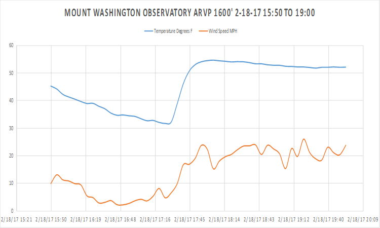
Fryeburg was not the only location that saw this quick alteration in conditions. The Observatory’s Mesonet station located at the base of the Auto Road experienced a sharp spike as well, only a few hours earlier.

Temperature (blue) and wind speed (orange) at the ARVP 1600’ station at the base between 3:30 and 8:00pm on February 18th. A sharp temperature rise of nearly 22 degrees, and an increase in wind speed was observed around 5:30 in the evening.
It certainly may seem hard to believe, but these crazy fluctuations in temperature have been observed and verified in and around the White Mountains many times before. The reason for these occasionally incredible temperature swings leads back to Mount Washington and the surrounding high peaks. When winds are moving at a moderate pace or higher on the summit, it is common to see downsloping winds on the leeward side of the summit. These winds occur as air travels up and over high terrain, and then descend with the elevation on the downwind side of the mountain chain. The strongest downsloping conditions occur when the wind is blowing in the direction that is perpendicular to the orientation of the mountain range. As the air accelerates downward, it is warmed due to compression, sometimes at a rate as high as 5 degrees per 1,000 feet of elevation. Given that there is over a 5,800 foot difference between the summit of Mount Washington and the Fryeburg Airport, downsloping certainly seems like the culprit.
While Saturday night’s temperature jump was impressive, it pales in comparison to the current world record. Spearfish, South Dakota in 1943 once saw a 49 degree spike in two minutes! The sudden change in temperature was so abrupt; it caused plate glass windows to crack. When the National Weather Service investigated the claims, it was determined that this was the result of a severe downsloping wind event.
Nathan Flinchbaugh, Summit Intern
Three and a Half Months of Snow, Ice and Rime
Three and a Half Months of Snow, Ice and Rime, with Deeper Drifts. By Ryan Steinke Me outside on the summit near the Yankee Building. My internship with the Mount Washington Observatory
Supporter Spotlight: Righteous Vices Coffee Roasters
Supporter Spotlight: Righteous Vices Coffee Roasters By MWOBS Staff Righteous Vices Coffee Roasters, a local coffee roaster and shop located in Center Conway, New Hampshire, has been a partner of the Observatory since 2024.
Winter Storm Tracks Across New Hampshire
Winter Storm Tracks Across New Hampshire By Alex Branton As winter comes to a close, most of us are ready for the warmer temperatures and sunshine that come with Spring and Summer. Although we


