
Dreaming of Convective Clouds
2012-09-10 15:14:36.000 – Mike Dorfman, Summit Intern
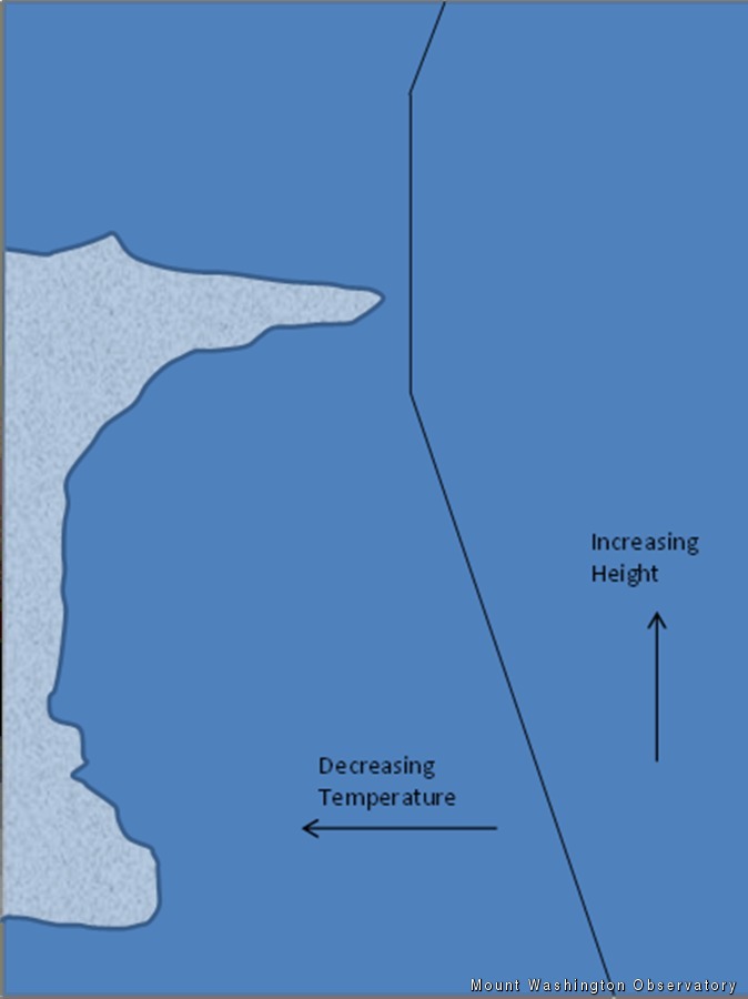
A diagram of thunderstorm formation
As summer slowly fades to winter, I am reminded of summer days full of warmth, travel and, best of all, thunderstorms. Although my parents’ dog doesn’t like it too much, whenever I see the little red line of severe weather barreling towards me on the radar I can’t help but get excited.
There are a few ways these severe storms can form. Most common on hot and humid days, the ground soaks up the sun throughout the day, quickly warming the air next to the ground. Just like a hot air balloon on a cold morning, this warm air rises past its cool surroundings. As it rises and expands, it slowly cools. If, at any point, this air reaches surrounding air that is the same temperature, it will stop rising. In this case, the atmosphere is considered ‘stable’. If, instead, the rising air cools at a slower rate than the air that surrounds it (eg, it is always warmer than the air around it), then it will continue rising.
Colder air cannot hold as much moisture in it as warm air, so once the air rises high enough and cools past its saturation point, a cloud will form. When water molecules in the air condense to form a cloud, they release a small amount of heat, warming the cloud even more and allowing it to rise even further. Cumulonimbus clouds can continue this pattern, rising to extreme heights.
Our atmosphere is broken into different levels. The troposphere, where almost all our clouds occur, spans from sea level to up to 50,000 feet. In the troposphere, air is generally cooler with higher altitude due to a decrease in pressure. However immediately above this level, the air is thick with ozone which absorbs much of the sun’s radiation, warming the upper level of air.
Once a cumulonimbus cloud reaches the top of the troposphere, the air surrounding it will soon match the temperature of the rising air. At this point, the rising air below it pushes the air to the side, allowing the cloud to ‘pool’ on the underside of the stratosphere. This causes the anvil shape of a stereotypical cumulonimbus cloud. Once precipitation starts to form, rain and hail can fall through the cloud, causing a downdraft and destroying the updraft that formed the cloud. At this point, without any more warm rising air to fuel the storm, the cloud quickly dissipates. This whole process is usually very fast and takes less than two hours.
Although it seems like thunderstorm season is nearing an end, I’m looking forward to the big storms which winter has in store for us!
Mike Dorfman, Summit Intern

Seek the Peak Spotlight: The Cloud Chasers
Seek the Peak Spotlight: The Cloud Chasers By MWOBS Staff Mike Bergeron and Desiree Bolton have been participating and volunteering for Seek the Peak for three years now. Together, they comprise Team Cloud Chasers

Celebrating 250 Years: The Declaration’s Legacy in the White Mountains
Celebrating 250 Years: The Declaration's Legacy in the White Mountains By Peter Crane We are now approaching July Fourth, Independence Day, the day when we celebrate the adoption of the Declaration of Independence in

Seek the Peak Spotlight: Ryan Shepard
Seek the Peak Spotlight: Ryan Shepard By MWOBS Staff Before Ryan Shepard moved to Conway, he was in Western New York celebrating his 40th birthday party. “I wanted to go big,” he said. “Big”
