Following the cloud theme from yesterday, I was able to take a good photograph of altostratus clouds
2011-11-03 19:55:35.000 – Kevin Cronin, Summit Intern
Following the cloud theme from yesterday, I was ab
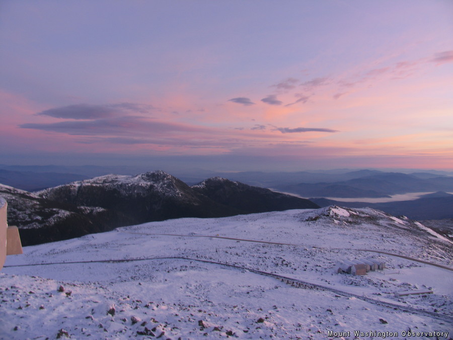
Following the cloud theme from yesterday, I was able to take a good photograph of altostratus clouds and cirrostratus clouds. The photograph I uploaded is taken from the observatory deck directed towards the north during sunrise. Within this photograph you can see (in the center of the picture starting from the right) the major peaks of Madison, Adams, and part of Jefferson. If you look on the eastern(right) portion of the photo you can see fog blanketing the valley down below. Altostratus clouds can be seen above Mount Adams. These thin mid-level clouds can be seen before frontal passages. Since they are in the mid-levels they typically fluctuate between being composed of ice crystals and water droplets.
If you look closely you can notice that above the altostratus clouds there is a grayish tint mixed in with the blue shy. This is from a thin upper level cloud layer called cirrostratus. Cirrostratus clouds are composed of ice crystals due to being around 18,000 feet in the air. Just like altostratus clouds they too can indicate a future frontal passage. Unfortunately the cloud theme will not be back tomorrow because we are headed back into the fog (cloud at the surface) due to an incoming cold front. However, a high pressure system will build in tomorrow night helping clear skies and increase visibility for Saturday.
Kevin Cronin, Summit Intern
Seek the Peak Spotlight: Sandy and Joan Kurtz
Seek the Peak Spotlight: Sandy and Joan Kurtz By MWOBS Staff Sandy and Joan Kurtz have been active supporters of Mount Washington Observatory for almost five decades. After visiting North Conway in 1980, they
Living the Night Life
Living the Night Life By Madelynn Smith My alarm goes off in the bunkroom, with blackout curtains obscuring the sun’s rays as it begins to lower in the sky. My day starts in the
Three and a Half Months of Snow, Ice and Rime
Three and a Half Months of Snow, Ice and Rime, with Deeper Drifts. By Ryan Steinke Me outside on the summit near the Yankee Building. My internship with the Mount Washington Observatory


