Freezing Fog and Rime Ice; what are they?
2019-03-19 11:53:19.000 – Jay Broccolo, Summit Intern
I’ve recently had a few people ask me what the difference between Freezing Fog and Rime Ice is, or more generally, what each of them is. It can certainly be confusing. The term Freezing Fog intuitively sounds like it is fog that is freezing but in actuality it isn’t freezing at all, at least not yet. The National Weather Service defines Freezing Fog as tiny, supercooled water droplets in fog when air temperatures are below freezing. In fact, it is possible to have supercooled water droplets suspended in the air down to temperatures as low as 40° F below 0° F (-40° F = -40°C). That doesn’t make sense, does it? Everyone knows water freezes at 32° F. Well, this is true as long as the water droplets have something called ice-nucleating particles to freeze on.
Higher in the atmosphere, these ice-nucleating particles become more sparse. Without some small particle, water droplets will stay in the liquid phase. Scientists have conducted many experiments exploring this concept, which has resulted in a number of results. I would like to point out a couple here. These ice-nucleating particles can be comprised of a bunch of different things. They can be dust particles, tiny sediment particles like different minerals (silica, feldspars, micas, etc), bacteria, and so on. These all have different properties which can have an effect on how and at what temperature water will freeze on these particles. Another finding is that pressure perturbations and atmospheric dynamics can also affect how water freezes. Not to get too deep, but water droplets suspended in the atmosphere can even freeze above 32° F if the force of impact is high enough altering said pressure perturbations and the surface properties of the water. Why is this important? Well, cloud formation is a massive undertaking when it comes to understanding them and how clouds precipitate out (rain, snow, hail, etc). These seemingly small factors are entrenched in better forecasting precipitation rates and accumulations. So if the weather world is to better forecast snowfall and rain rates, understanding cloud formation and how ice nucleates in the upper atmosphere is essential.
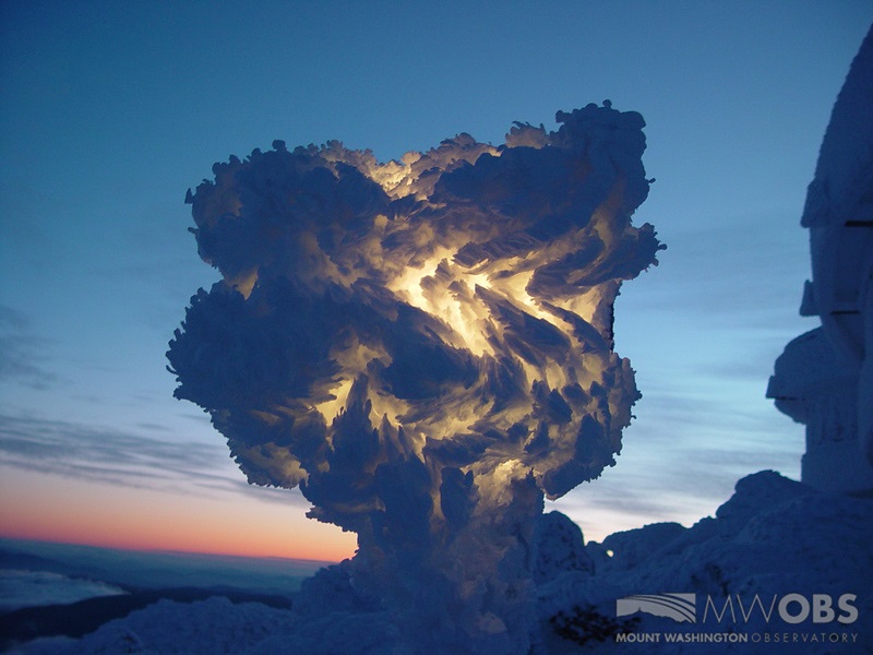
That being said, let’s bring it back to Freezing Fog and Rime Ice. We now know that Freezing Fog is not frozen and that it is actually tiny, supercooled water droplets suspended in the atmosphere, in a cloud, without anything to nucleate on. This is where Rime Ice comes into play. When these supercooled water droplets come into contact with something that also is below freezing, they now have something to nucleate on. For example, our weather tower and its instruments act as a nucleating catalyst. Down at the sea-level or anywhere else for that matter, it may be a mail box, tress, or powerlines. It could be anything. On the summit of Mount Washington it is the rocks, buildings, and anything physical, even us observers! So, Rime Ice is a by-product of Freezing Fog and is a fractal structure that builds with time in the direction of where the wind originates from. The colder the temperatures, the softer and whiter the Rime tends to be. As you approach the freezing mark, the Rime becomes harder and becomes more translucent until you have Glaze Ice, which is clear and extremely hard but deposited in the same fashion. While Rime Ice can be stunning and invoke some serious wondrous eye sights, it can also be very dangerous. It can dislodge from its surface and become flying debris, it can take down tree limbs and power lines, cover exhausts, and create black ice, so be aware of your surroundings when it’s around. On that note, I will leave you on a high point with a beautiful picture of it on our Precipitation Light, a picture taken by a past observer.

Jay Broccolo, Summit Intern
Seek the Peak Spotlight: Sandy and Joan Kurtz
Seek the Peak Spotlight: Sandy and Joan Kurtz By MWOBS Staff Sandy and Joan Kurtz have been active supporters of Mount Washington Observatory for almost five decades. After visiting North Conway in 1980, they
Living the Night Life
Living the Night Life By Madelynn Smith My alarm goes off in the bunkroom, with blackout curtains obscuring the sun’s rays as it begins to lower in the sky. My day starts in the
Three and a Half Months of Snow, Ice and Rime
Three and a Half Months of Snow, Ice and Rime, with Deeper Drifts. By Ryan Steinke Me outside on the summit near the Yankee Building. My internship with the Mount Washington Observatory


