
High Winds on the Horizon
2016-09-09 13:33:07.000 – Mike Carmon, Senior Weather Observer & Education Specialist
Now that we’ve turned the calendar into September, signs of the impending winter are starting to appear in the computer forecast models. September is by no means considered winter for us, but on average, the weather begins to take a decided turn that direction during this ninth month of the year on Mount Washington’s summit.
For instance, August’s average monthly temperature is 48.1°F, while September’s monthly average plummets to 41.6°F. While the lowest temperature ever recorded (since MWO started gathering data in 1932) in the month of August is a cool 20°F, the lowest ever observed in September is a decidedly-chillier 9°F.
The average monthly snowfall for August stands at a mere 0.1 inches.
September’s monthly average? 2.2 inches.
Which means our first measurable snowfall for the winter season, on average, does tend to occur in the month of September.
Then we arrive at wind speed.
In short, big winds are coming.
The on-summit staff has been paying particular attention to a surface low pressure system forecasted to develop over the Great Lakes region tonight. As the system moves northeastward towards New England, an associated upper-level trough will deepen, which will likely result in rapid intensification of the surface low as it charges through southern Quebec. Also, a ridge of high pressure will simultaneously strengthen over the Ohio Valley in the wake of the low, which will result in an exceptionally tight pressure gradient over the northeastern United States.
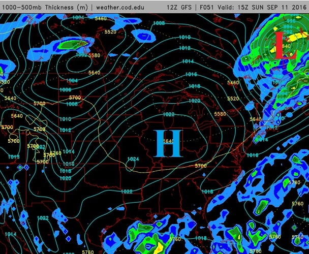
The tighter the pressure gradient (in other words, the larger the change in pressure over a smaller distance), the higher the winds. When summit meteorologists see New England squeezed between a 1024 mb high and a 986 mb low, it is a sure sign to us that the first high wind event of the season is very much in the cards!
At this time, Sunday afternoon and evening look to harbor the highest winds, with sustained speeds on the order of 60-90 mph possible, and gusts in excess of 100 mph looking ever more likely.
Winter is indeed on its way.
Mike Carmon, Senior Weather Observer & Education Specialist

Seek the Peak Spotlight: The Cloud Chasers
Seek the Peak Spotlight: The Cloud Chasers By MWOBS Staff Mike Bergeron and Desiree Bolton have been participating and volunteering for Seek the Peak for three years now. Together, they comprise Team Cloud Chasers

Celebrating 250 Years: The Declaration’s Legacy in the White Mountains
Celebrating 250 Years: The Declaration's Legacy in the White Mountains By Peter Crane We are now approaching July Fourth, Independence Day, the day when we celebrate the adoption of the Declaration of Independence in

Seek the Peak Spotlight: Ryan Shepard
Seek the Peak Spotlight: Ryan Shepard By MWOBS Staff Before Ryan Shepard moved to Conway, he was in Western New York celebrating his 40th birthday party. “I wanted to go big,” he said. “Big”
