hike to jefferson
2008-09-21 06:29:56.000 – Jeff Wehrwein, Summit Intern
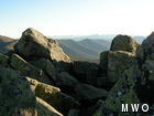
Peaking out from the summit of Jefferson
The weather this week has been wonderful, if a bit chilly. We spent all of Thursday below freezing with a brisk wind and clear skies. Yesterday the sun shined brightly and the wind was calm, so the 45 degree air felt like 60 on the summit. Jordan and I took advantage of this comfortable weather to take a hike to Mount Jefferson, which is the next peak to our north in the presidential range after Mount Clay. It is about 3 miles each way, so we started out early in the afternoon to make sure we would be back before dark. With the sun setting before 6 pm (summit time), the afternoon isn’t as long as it used to be.n
nVisibility was over 100 miles all day, so the views were excellent. The nice dry rocks and light winds also made the hike to Jefferson quicker than I expected. The last time I hiked in that direction it was foggy and traction on the rocks was sketchy at best, so I was happy to have such beautiful hiking conditions.n
nMount Jefferson is 5716 feet tall, but we can’t exactly say we conquered a 4000-footer. The lowest point between Washington and Jefferson is Sphinx Col, which is at 4959 feet. If you ignore the slight ups and downs between those three points, we descended 1300 feet to Sphinx Col and then climbed 750 feet back up to Jefferson. Spread over 3 miles, this route is moderate compared to some other hikes around here. For comparison, the Great Gulf trail drops 2000 feet in about a mile.n
nOn the way back to the summit, the sun began to sink in the sky and the warm breeze suddenly became a chilly one as the sun’s heat dwindled away. As the sun perched on the horizon, Camel’s Hump was backlit beautifully, and Jordan and I marveled at the silhouette of the Green Mountains. We enjoyed the sunset from the trail, and made it back to the summit just as the light was fading away.
Jeff Wehrwein, Summit Intern
A Look at The Big Wind and Measuring Extreme Winds At Mount Washington
A Look at The Big Wind and Measuring Extreme Winds at Mount Washington By Alexis George Ninety-one years ago on April 12th, Mount Washington Observatory recorded a world-record wind speed of 231 mph. While
MWOBS Weather Forecasts Expand Beyond the Higher Summits
MWOBS Weather Forecasts Expand Beyond the Higher Summits By Alex Branton One of the most utilized products provided by Mount Washington Observatory is the Higher Summits Forecast. This 48-hour forecast is written by MWOBS
One Down, One To Go
One Down, One to Go By Ryan Knapp On my calendar for March 2025, I had two reminders of events to look forward to in the sky. The first occurred this past week with


