
How Do Lenticular Clouds Form?
2018-12-11 04:34:52.000 – Christopher Hohman, Observer/Staff Meteorologist
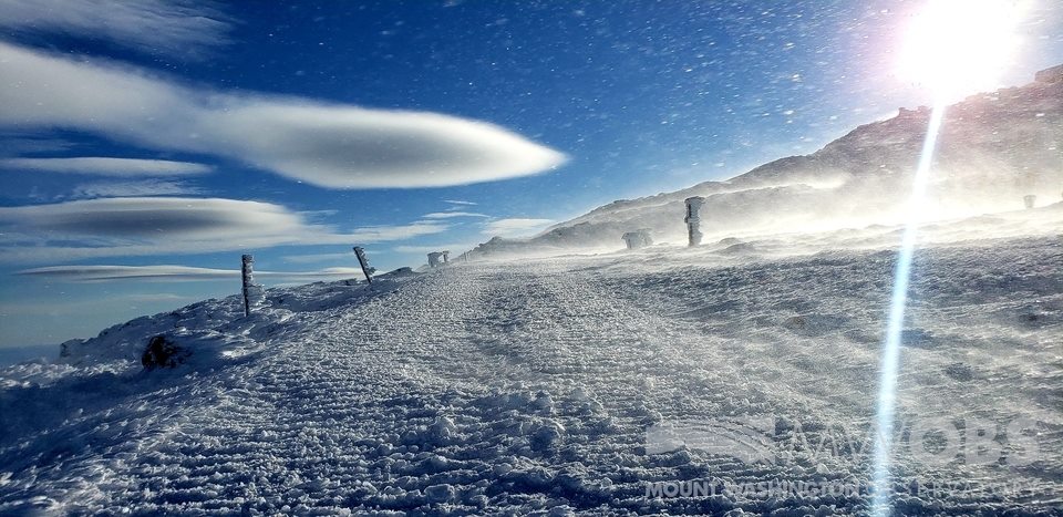
We had some of my favorite clouds form over the summit a few days back. They are the infamous “Lenticular Clouds.” These beautiful clouds are very unique to mountainous regions, and do not form over areas that cannot obstruct wind flow. While they are always a treat to observer, I thought I’d spend this blog talking a little bit about how they form.
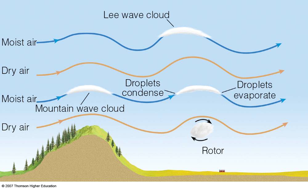
So, the graph above here has some fancy terms, but I’ll break it down for you to understand. Imagine for a moment that there is a box of air at the bottom of the mountain. This box of air (or as meteorologists call it, a “Parcel of air”) can be pushed, squeezed, or stretched by wind. Now our box of air has some certain characteristics to it. This air is moist, meaning that it has a high relative humidity. This air is also stable, which means that it is not going to rise randomly into the atmosphere on its own.
Now, imagine that some wind beings pushing our box of air into the mountain. It has to go somewhere, so it begins traveling up the left side of the mountain. The mountain is essentially lifting the box higher in the atmosphere. Normally it wouldn’t do this, because like I stated early, it’s a stable parcel, not going to rise on it’s own. This is where the lenticular formation actually starts to come into play.
Our box of air has a certain “Dew Point.” That is a very fundamental meteorology term, and it is the temperature at which a parcel of air will condense into a cloud. Let us say our box’s dew point is 25F. At the surface, we will say the ambient temperature is 30F, and right above the mountain, we’ll make the ambient temperature 25F. So our box is pushed along up the mountain, and isn’t experiencing any condensation yet, due to the fact it hasn’t reached it’s dew point. One it reaches the peak, it has finally reached it’s dew point! So when this happens, it will condense, and happily form a cloud.
The key here is that the box of air never would have reached that cold level in the atmosphere, if it wasn’t for the mountain forcing it upward. That’s the basic reason why we see these lenticular clouds form. Now the diagram above shows a wavy pattern. I’m not going to go into that in depth (it gets very complicated), but essentially our box of air will start moving in a wavy pattern through the atmosphere. This can create a line of lenticular clouds. In fact, we observed this just the other day! Check out the link here!
That was a lot of meteorology thrown at you, but if you have any questions, please do not hesitate to contact us! Essentially it comes down to our box of air getting forced up the mountain, and therefore condensing into a cloud. I hope you enjoyed the science lesson here! I know I did. This stuff is really what I live for, and I could talk about it all day.
I’ll leave you with one more picture. Thank you so much for reading, and I’ll see you guys on my next blog!
Christopher Hohman, Observer/Staff Meteorologist

Seek the Peak Spotlight: The Cloud Chasers
Seek the Peak Spotlight: The Cloud Chasers By MWOBS Staff Mike Bergeron and Desiree Bolton have been participating and volunteering for Seek the Peak for three years now. Together, they comprise Team Cloud Chasers

Celebrating 250 Years: The Declaration’s Legacy in the White Mountains
Celebrating 250 Years: The Declaration's Legacy in the White Mountains By Peter Crane We are now approaching July Fourth, Independence Day, the day when we celebrate the adoption of the Declaration of Independence in

Seek the Peak Spotlight: Ryan Shepard
Seek the Peak Spotlight: Ryan Shepard By MWOBS Staff Before Ryan Shepard moved to Conway, he was in Western New York celebrating his 40th birthday party. “I wanted to go big,” he said. “Big”
