In Search of Wintry Weather: A Look at the Week Ahead on Mount Washington
2019-09-09 08:30:46.000 – Thomas Padham, Weather Observer/Education Specialist
With our much-advertised below freezing temperatures last night being a bust, (we sat at literally 32.0-34 degrees all night) I’ve decided to take a look at our next chances for potential wintry weather. “Wintry weather” we’ll define as at least some icing conditions, with rime or glaze ice forming on the summit surfaces, or better yet, snow! It’s still quite early for us to see significant snowfall this time of year, but typically by mid-late September the summit has seen our first snowfall, and riming or glazing conditions often occur earlier.
We did see some very brief glazing conditions for roughly an hour overnight on Wednesday the 4th, but the amount of ice was very miniscule, and by the time the day observers had awoken the ice had already melted. This past weekend looked much more promising from the models, but temperatures ended up being a solid 3-4 degrees warmer than expected through the night. The weather models we use for our forecasting tend to have some “hiccups” this time of year as we transition from summer towards fall. This is due to a built-in equation change as we head towards winter, and sometimes that change should have happened sooner or later depending on the type of short term weather pattern we’re currently seeing across the area.
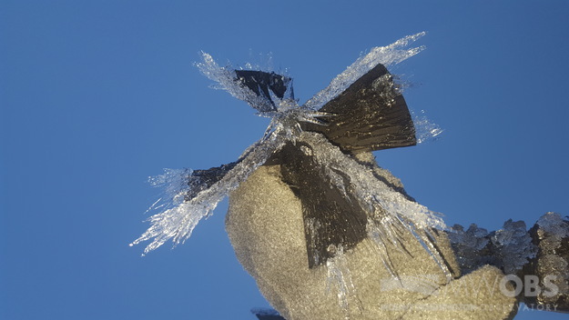
Taking a look at the big picture weather over the next 10 days or so, we’ll have a few chances at some below freezing temperatures and at least some glaze ice. Glaze ice is formed near the freezing mark, from liquid water that has settled onto surfaces and then slowly freezes. This is the same as ice we see with freezing rain, and can be very slick and also a pain to remove from our instrumentation. It’s my least favorite type of weather up here, but it’s still wintry!

Temperatures are expected to warm up significantly over the next few days, with a warm front and rain showers Wednesday allowing temperatures to surge up into the 50s. Behind this system we could have a chance at reaching just below 32°F overnight Thursday the 12th into Friday the 13th, but it’s not looking all that likely and also there’s a fair chance the summit will not be in the clouds during that time.
Getting way ahead of ourselves, in the even longer term the GFS has shown a more significant storm and associated cold front crossing New England sometime during the middle of next week (the 18th and 19th). This one has consistently had below freezing temperatures for the summit, possibly getting down towards the lower 20s. With some residual moisture this would also lead to our first real chance for some snow showers. It’s still over a full week away but I’m hopeful to see our first taste of snow on our next shift!
Thomas Padham, Weather Observer/Education Specialist
Three and a Half Months of Snow, Ice and Rime
Three and a Half Months of Snow, Ice and Rime, with Deeper Drifts. By Ryan Steinke Me outside on the summit near the Yankee Building. My internship with the Mount Washington Observatory
Supporter Spotlight: Righteous Vices Coffee Roasters
Supporter Spotlight: Righteous Vices Coffee Roasters By MWOBS Staff Righteous Vices Coffee Roasters, a local coffee roaster and shop located in Center Conway, New Hampshire, has been a partner of the Observatory since 2024.
Winter Storm Tracks Across New Hampshire
Winter Storm Tracks Across New Hampshire By Alex Branton As winter comes to a close, most of us are ready for the warmer temperatures and sunshine that come with Spring and Summer. Although we


