
Monday’s Winds and Cold
2015-01-06 22:34:37.000 – Ryan Knapp, Weather Observer/Meteorologist
Monday and Monday night can be summarized by two words: cold and windy. As low pressure from Sunday exited, it dragged a strong arctic cold front south and eastward bringing the first blast of cold air for the week ahead. From 0000 EST to 2400 EST, the summit dropped 43F degrees going from 19F/-7C all the way down to -24F/-31C before finally bottoming out. As temperatures were dropping, winds were increasing as a tight pressure gradient set up behind the exiting low to our northeast and an incoming high from our west. As winds ramped up over the day, summits saw a gust over 100 mph for nearly every hour before finally peaking at 129 mph at 2146 EST. And since all anyone tends to focus on during high winds and cold temperatures are our wind chills, the lowest I was able to find and calculate from last night was -74F/-59C (I say “find” since we do not keep an archive of these values since they are not a solid measurement).

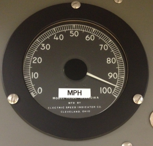
With the cold, we were able to show our special overnight guests the ability to turn boiling water into snow (ice crystals to be more specific) and showed bubbles freezing in the air before hitting the ground (although, both of these demonstrations work much better closer to 30 below up here due to our typically high RH values). Additionally, we watched as they attempted to walk around on the deck during the day prior to the higher winds and low temperatures overnight. And several people took the opportunity to snap a pic of our speed indicator as it was pegged out at 100 mph (see below). We posted a similar picture on social media and had to continually respond to people thinking that our instrumentation was limited to 100mph. This is not the case – what this indicator is used for is a quick reference and nothing more. Our winds are recorded digitally and on an analog form that are calibrated to upwards of 285 mph or higher. So no worries, we were able to easily measure yesterday’s high winds and are ready for recording the next Big Wind when it occurs.
Ryan Knapp, Weather Observer/Meteorologist

Seek the Peak Spotlight: The Cloud Chasers
Seek the Peak Spotlight: The Cloud Chasers By MWOBS Staff Mike Bergeron and Desiree Bolton have been participating and volunteering for Seek the Peak for three years now. Together, they comprise Team Cloud Chasers

Celebrating 250 Years: The Declaration’s Legacy in the White Mountains
Celebrating 250 Years: The Declaration's Legacy in the White Mountains By Peter Crane We are now approaching July Fourth, Independence Day, the day when we celebrate the adoption of the Declaration of Independence in

Seek the Peak Spotlight: Ryan Shepard
Seek the Peak Spotlight: Ryan Shepard By MWOBS Staff Before Ryan Shepard moved to Conway, he was in Western New York celebrating his 40th birthday party. “I wanted to go big,” he said. “Big”
